Posts

Showing posts from March, 2012

sketches

Image
My "in situ" sketches for the month of March. Waiting to get my car unlocked to get at the keys, should have just gone hiking . Rocks and plants along Mission Creek . The falls on the creek . A bit of tree making its living on the wall in Millard Canyon . Spring in Lion Canyon .

Lion Canyon and Rose Valley Falls

Image
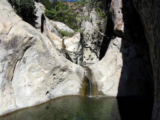
Los Padres National Forest Locate the trailhead. I decided to go out and see the waterfalls shown on the map behind each camp on the east and west fork of Lion Canyon and while I was there, visit Rose Valley Falls, too. I hadn't quite decided to make it all one hike in a big loop by the time I had started. I did know the loop without the extra treks out to the various falls has been reported to be about 5 miles and since the extra wasn't all that much, I felt I could do it. And, sure, it is a much shorter single hike if parking at Rose Valley Campground and just using the connector, but I had decided I wanted to hike the lower canyon as well as the connector. Really, the only question was loop or out and back. Doing the loop, it would have made sense to park somewhere up the road like at the information sign, but I drove down to Middle Lion and started off from there. Starting off with a creek crossing that took advantage of the waterproof boots on a row of placed

Dawn Mine

Image
Angeles National Forest Map link. I tried to get Abbie out of the lab for at least part of the weekend with a short hike overnight, but didn't manage it. I did manage to get her out for long enough to hike around the local area and it turns out there's a popular hike that we had both missed so far in our time in Pasadena. We set about finding our way to Dawn Mine from Sunset Ridge. We found our way down Cheney Trail and parked off the road not too far from the locked gate on the fire road that marks the start. We signed in at the register and tried to make sense of the tagged map beside it. At the register, trails head down to Millard Canyon (nice trail, about a mile there), out to the front of the hills, and continues along the ridge, soon coming to one more trail. We continued just a little up the ridge and turned down this trail. Sunset Ridge Trail (12W18) splits off from the paved fire road and makes for a much nicer hike. For now, it also comes with scary w

Seven Falls and Three Pools

Image
Santa Barbara front country Map link. The past weekend's rains may or may not promise a bit of water flowing over the local waterfalls. There were a couple soaking rains at the beginning of the season, but the middle of the rainy season has seen nothing significant. I was in need of a hike, having not done anything for too many days, so I decided to go up to Seven Falls, a popular destination not too all that far up. While I was looking for a short hike, I decided to leave options open for more hiking after the falls by printing out a bit of map before going. Some folks hike all the way up to Tunnel Trail along the creek bed, some go up Cathedral Peak, just a short way away, and some head up Jesusita, and those are just the more obvious options. I got near the end of Tunnel Road and parked in a large lot-like area rather than playing with parallel parking. There were some particularly bad parallel parkers up along the street begging for tickets in what is fabled to be a

Nicholas Flat

Image
Leo Carrillo State Park Locate the trailhead. I headed down to celebrate Holi on the beach and while I was along PCH with a few more hours of daylight, I might stop by one of the many state parks in the area and see what it had to offer. I decided to stop at Leo Carrillo, named for the actor who played the Cisco Kid's sidekick (that's what the brochure says), at the very western edge of Malibu and Los Angeles County. It didn't look promising because there's a sign by a trail near the entrance that says it's only 0.6 miles long and otherwise very easy. That doesn't seem like a hike to me. The ranger at the entrance station said there were actually trails from that one that were quite a bit longer going to a pond high above. Parking is $12 in the state park lot or free along the side of the highway, but only legal on the ocean side. A sign indicating that beyond is a walk so easy you won't notice you went on it, but not mentioning that a few fee

follow by email