Ortega Peak
Los Padres National Forest
At the Holiday Hooplah for the Hundred Peaks Section, we were asked to tell a truth with our name in introductions. I said that I was planning on hiking up the delisted Ortega Peak. It may be a lame truth, but it fit in with the rest of them quite well. There is no Ortega Peak, really, but a benchmark labeled "ORTEGA" is shown on a high point east of Ortega Hill on the 1942 Wheeler Springs map. Their name is based on this benchmark. I had been meaning to go to "the real Ortega benchmark" for quite some time, but was finally reaching the tipping point to actually doing it. ("Real" distinguishes it from the "ORTEGA" next to the road on the 1995 map.) The most sensible route is to start at Cherry Creek Road, a popular illegal target shooting area and the reason the peak was delisted. In particular, it was an incident in which someone ducked down for a good squat just in time for a bullet to whizz overhead. (I was told this in the first person.) For me, this means try to hit it on a weekday. In fact, try to hit it one of those most unpopular weekdays that start with a "T". My experience with the road when hitting it at the top of Upper North Fork Matilija made me want to be sure it was dry. The trouble is, just as I was ready to go, the rain would come up and wet it down making me put the trip off for another week. With rain again threatening, I decided to go ahead and brave a Friday, the worst of the weekdays for avoiding target shooters. I planned on coming out again after dark when they would be gone again if they come. Well, except the worst ones, the drunk ones. It is a gamble.
I arrive at the gate to Cherry Creek to find no cars at all. So far, so good. I have also realized halfway through the drive that the camera next to the pack never got into the car. I thought one of the smaller Canons might be in a bag I did grab, but it is not. The only camera I have is one I have never tried on a cheap 7" tablet. It is forward facing, so I cannot see what I am doing even if I can see the screen in the sunlight. I expect dreadful things from it and it surpasses my expectations most extraordinarily. This does not matter. The hike is the important thing. I take off with a nagging feeling of forgetting something, loop back to get my poles, and take off again.
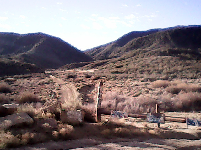
The road drops across a wash and continues at a very gentle uphill past the various shooting galleries all marked closed for target shooting. It is a lot cleaner than I expect given all the stories I have heard. It is less than a mile to leave the large flat and start up the canyon. That same natural gas pipeline exits the canyon with the road at the narrow spot and heads off in another direction at the flat. The target shooters have shot up the warning signs for this 30" high pressure pipe. Further up, the pipe is exposed while it crosses the creek, but they have refrained from too much destruction on the sign there. By some rocks, I hear a noise echoed off their many surfaces. It sounds like it could be bees or maybe a plane overhead. I have difficulty believing that it is actually water, but along another turn, I can see it flowing below. There really is a creek here. The flow gets stronger as I head up, then vanishes again. It was nice while it lasted.
The road keeps on with a gentle climb. There is a large slab of concrete to the side that was probably part of the Cherry Creek Campground once. There are a couple very large trees, at least 5 foot diameter, in among all the majority of scrawny things. The road gets steeper as it takes a short switchback and climbs up out of the canyon to the top. It is just short of 3 miles to the junction with the trail along the Upper North Fork Matilija Creek. The road ends shortly after the trail, turning into Ortega Trail, a motorcycle trail. Views to the ocean open up as I climb. The cities are covered over with a very soft fog. I think I can pick out a little bit of island.

I am relying on Bob Burd's trip report to help navigate, assuming he means the junction with the trail and road as where the "old OHV road forks". He says it is another mile around the bottom of Ortega hill and to the trail on the left, marked by a cairn. Just short of 4 miles along, I do find a cairn beside the trail. Behind it, a narrow trail still climbs upward. I was expecting this to go up a ridge a little further along, but it is actually just before a gully.
I turn up this trail and start to climb. It stays just high enough above the bottom of the gully that it is unlikely to wash out. Except for some bare spots, it also remains narrow, but open, all the way up to a local peak. The sort of hiker who takes beer rather than water has been up here, enjoying the view. It is a nice spot, but not yet the peak. Far down a sharp ridge is the peak I am looking for.
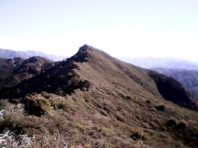
The trail continues east from the shorter peak and a last few scattered beer cans are along it as it goes. It clambers over rocks and downward, then launches out over the steep north slope among some stocky oaks. It feels much safer when it travels on the south side of the ridge through the scrubby chaparral. The slopes below the excursions to the north seem to get steeper. A misplaced foot would lead to a fall that could not be stopped soon enough and I am glad to be wearing my shoes with the biggest lugs. I am not glad for the wind of the incoming storm that keeps trying to push me off to the north. As I get near the top, the trail gets back to the south side of the ridge and travels over some highly slanted sandstone before winding up at the top. Just short of 5 miles along, I am standing at the top.
The register is in some rocks on the highest rock. No one has signed it since Peter Doggett's 12th ascent in May 2012. Besides that, there are a couple other HPS climbers since Bob Burd and his brother. I am surprised that his trip report has not generated at least a little interest in the peak. Mars Bonfire with his 25 list finishes has only been up here three times. Next to the large rock at the top, there is a large hewn timber, but nothing else from the indicated benchmark.
The peak has a few trees that block east and west, but stepping north or south of the ridge yields 180° views. South views show the coast is still under a soft layer of low fog. I cannot seem to easily pick out Dry Lakes Ridge below me. To the north, a backbone of sandstone drops away much less steeply than all around it. If this peak were a going concern with many visitors, they would all want their picture taken while balancing out on that backbone.

The trail is a lot less scary on the way back down. I am not sure how that works. I am back to the shorter peak quickly. There seems to be a little bit of trail heading down to the pipeline cut and I am tempted to take try that route. It is clear that the motorcycles are keeping some parts of the pipeline route open, but this part is probably steep even for them. Back to the trail, it is barely lunch, so I continue along to see more.
At the next saddle where the pipeline goes through, the bikes have only gone up the other side. I could probably have found a steep, but open route down from the top of the cut if I had tried. On the other side, target shooters have taken advantage of the cleared hillside for some fun. I wonder if they realize why it is clear. Below this, the trail takes a steep and rocky downward turn. After a half mile or so, it climbs again and splits. Trail heads south along the pipeline to a creek and, on the right map, joins the Upper North Fork Matilija at the random road sign along it. This is marked "no motor vehicles", which the bikes clearly do not appreciate. On the other side is Ortega Camp.
The camp has two tables, one wood and one metal. The metal one is leveled by pieces of the wooden one. A number of fire pits circle the area, but only the center one has been spared target practice. It seems bleak to me, but I expect others have had some very exciting times up here. This seems like a good turn around spot, so after a bit more to eat, I head back up.
The rocky, steep section seems longer on the way up. Once at the top and circling back around toward the road, the coast seems to have given up its fog. Now I can not only see that it was a bit of island that I was seeing in the morning, but it was Anacapa. The string of islands look quite stunning now. On the other hand, it feels much less like wilderness now that I can see buildings. I rather want my camera at the moment and have been feeling ever so slightly, well, nude without it. I enjoy it for a bit, then continue on. It is all downhills from here back to the road.
©2015 Valerie Norton
Posted 8 February 2015
Liked this? Interesting? Click the three bars at the top left for the menu to read more or subscribe!


Comments