Williamson: Anvil Camp
Inyo National Forest
Manzanar National Historic Site
DAY 1 | DAY 2 | DAY 3 | DAY 4 | DAY 5 | DAY 6
The sun gets up appropriately early when camped out around The Pothole. My bear canister seems inappropriately empty. Apparently I did not quite figure out that I needed one more breakfast than supper. There is no breakfast for me in there. Ralph has about a pound of oatmeal he has not eaten yet, so there is plenty to eat. But where are the raisins? Where is the cinnamon? Oh, are beggars not supposed to be choosers? I dump the last of my blueberry juice infused cranberries (surprisingly yummy) into the mix and it is good, but it really needs a mass of cinnamon. Allspice can be nice, too.
We pack up for the last time and head down passing a couple groups coming up from Anvil Camp. Add to them the trail crew staying there and it must have been a little crowded there last night. There are indeed a lot more mosquitoes down in the more common camp area. The trail crew is back on the job at the bottom of camp. Most of them are far above the current trail because they have decided they will have better luck keeping a trail up there. To me, it looks like they are sticking it at the bottom of a funnel, but maybe I am not seeing the big picture. They have a bit of tread in, so I go up and try it out. It is a long way up.
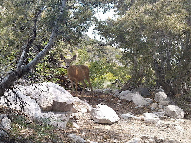
As we descend the switchbacks into Mahogany Flat, it is getting hot and I am getting hungry already. I stop under a good tree just a few feet from where we camped and quickly come upon the one big wildlife sighting of the trip, or rather it comes upon us. A deer comes out of the growth at the side, nibbling on various things. Almost exclusively, she is going after the seed filled stalks of a plant that looks parasitic. They must be delicious. I munch and she munches for a while. She is watchful of us as she crosses the trail to find more of the red-brown stalks and continues into the growth again.
We continue down some more to the little creek with its waterfall. The shade is welcome and the water is like air conditioning. It is hot enough to want to dunk something in it, so I go for it. The hat comes off, scoops up its fill, then comes back on. The water is cold as it runs down. It is especially cold when I straighten up and it runs down my back. After the momentary shock, it is just a lot of pleasant. It is particularly nice as the trail takes to climbing again, but evaporates all too quickly. That is quick dry clothing for you.
It is beginning to cloud up again. Between that and the general gain of elevation, it is cool enough to climb. The main bit of work to get out is to the first saddle. The sandy trail at the top does not help with the climb. After that, the walk is much nicer and easier although still climbing. I pause for more lunch bits at the very top to let Ralph catch up. Zooming because there are many miles to cover is all well and good, but it is a good idea to stick together a little bit.
It clouds up more as we go down into Symmes Creek. I imagine that the creek is running just a little bit higher today than before. It seems to be getting a little higher over one rock I used in the previous crossing and now it does not look attractive anymore. I almost manage to slip right in on the first crossing going for a different rock for the hopping.
As we leave the wilderness and head out into the desert, there are a few raindrops. It is a perfect time for it. Too bad it does not last. Wednesday seemed to be the peak of the afternoon thunderstorms, so I am expecting today to be milder than yesterday. It seems to be so. The rain does not hold up for long, but the clouds persist for a bit before getting patchy a little too soon.
We skip the stock trailhead this time and wander past the hiker parking instead. There are a lot of cars and room for more. One guy getting a ride back to his car after coming out a different trailhead stops to chat. We stop at the Shepherd Creek crossing for water since it is our "last" water with a bunch of miles to go. The water coming down the creek feels warmer than before, which seems unlikely to be true.
The hard road is starting to wear on Ralph's feet a lot and I want to pass by the reservoir on the way into Manzanar. He finds what looks like a trail parallel to the creek that should run into the road to the reservoir, so we go for that. Unfortunately, the trail is a lot harder to see at ground level. There really is not one. We find a mining claim and I go investigating what is being witnessed by a post with ribbon on it (nothing), but mostly it just makes our travel slower to go this way. But it is softer for tired feet. There is a ford marked along an old road, but it would challenge any vehicle that tried it today.
The reservoir is interesting. The camp was not finished when they forced everyone into it. The reservoir was built by the prisoners and contains many artistic flourishes. Much of the engineering is on display as well. It is quite interesting. The sun is getting low, so we cannot spend too long at it. We continue on as darkness falls, rejoining the road we left the camp along. It brings us to camp at an appropriately darkened time for sneaking back through the barbed wire.
Once inside, we return to the monument where we started. Ralph leaves the lure he was fishing with, but removes the hook for safety. This is not where we will end. We asked for the car to be left in the main parking lot this evening, so we still have a little way to go. The old roads through camp are faint where they are not currently in use. We pass by a few of the water gardens as we go, then follow some of the abandoned roads. Sometimes the paving is still there, sometimes they are choked with sage. Eventually, we find ourselves beside the car and the headlamp with the only battery that has not yet failed manages not to fail.
It is late and we have not had supper, so we stop. I thought it was too late for Lone Pine, but after stopping and getting stuff at the first place open, noticed that there are still quite a few places open. Pizza just down the street sure would have hit the spot better. Guess I cannot have everything. But a mountain got climbed and lakes got fished.
Words ©2016 Valerie Norton
Photos ©2016 Ralph On Earth
Posted 1 September 2016
Liked this? Interesting? Click the three bars at the top left for the menu to read more or subscribe!


Comments