Posts

Showing posts from April, 2016

sketches

Image
Not too many again. A few of the rocks and a pine while on a short trip along the ridge named for both . A piece of the Pacific Crest Trail that is quite well maintained just south of San Francisquito Canyon.

San Francisquito Canyon

Image
Angeles National Forest Click for map. It is quite a nice day as I arrive at the bottom of Jupiter Mountain before basically deciding that the stars are not aligned for that hike and heading over to San Francisquito Canyon to hike north along the Pacific Crest Trail. The first through hiker of the day thinks I might be stopping for him. They are getting too coddled if they expect a car joining three other cars at a trailhead is stopping for them rather than for its occupant's own selfish reasons. The humans are not aligned for traveling north. It can be hiked up to Grass Mountain, but is closed after that. There is no forest order posted, but it is due to the Powerhouse Fire. Oddly, the last order for that seems to have expired in October last year. I grump with the through hiker about forest closures for a bit. He asks about my camera since his own dSLR was the very first thing that went home. Eventually I give in and head south instead of north. It will allow me

Vasquez Rocks

Image
Natural Area Park, Los Angeles County Click for map. I decided to join a bunch of geocachers in a celebration of life by going on some interrupted plans made 5 years before. The destination is one we all know although we probably do not realize it. No one pays quite as much attention to the landscape stars, but this particular landscape has been seen on screens of all sizes and continues to be. They can even be found in animated form. Today, there are quite a lot of folks enjoying them in park form. We stop by the interpretive loop for a brief geology refresher (and the earthcache) before heading off on a spur filled loop around the place. The most climbed rocks of the day are right next to the parking lot. We only climb a little way up and then return.

Simi Peak

Image
Lang Ranch Open Space Oakbrook Regional Park Santa Monica Mountains National Recreation Area Woodridge Open Space The original plan was a shuttle hike along the Albertson Fireroad, but the instigator of that plan decided against hiking today after all. By bending the route around, I could get the peak, so I went for much of that original plan anyway, just removing the need for a shuttle. There is plenty of parking at either trailhead and a packed dirt path connects the two. I choose to start at Oakbrook View Trail, which comes first along the road. The sign is offset from the road, but it is still easy to find at the start of some park areas. An open space across from a park where a line in the grass leads to an information sign. I will start here. The trail starts climbing through oaks up a little hill. Houses built on a few different plans stand in neat curves below, but not for very far. Grassy hills surround the neighborhood. A light mist lingers in the gen

Rocky Pine Ridge

Image
Los Padres National Forest A warm day is a good day to head up the mountain. It is a little cooler up there. I went up to the top of Gibraltar for a short, mild scramble of a hike out to Rocky Pine Ridge. There are other ways up, but this is the easy one. To prove it is easy, I fail to find the correct trail at first and have to make a second attempt. Once on the correct trail, the way might still not be obvious. The surface is shale and there are plenty of apparent routes through the brush. There have also been many people out here recently and the path they walked is obvious by the shapeless footprints. A little higher, as the track winds up a northern slope, the brush closes in and makes losing the route impossible. The sloped shale makes uncertain footing. La Cumbre topped with a decaying fire lookout and the tooth of Cathedral start the march of peaks to the west. It seems to finish climbing and then starts wrapping around the little peak. Soon my destinati

Devils Canyon

Image
Los Angeles County Trail Oat Mountain seems like a place to go to see some flowers and Devils Canyon looked like a fun and challenging way to get there. The first challenge is where to start since the trailhead seems to be within a gated community. The geocachers have a suggestion, so I took it and parked in a small dirt lot beside a larger, fenced lot. There is a trail up and around the side of the fence and an old road down into the canyon. Both look, at first glance, to be well used. My impression when looking before was that the trail stays high, but the canyon is lush and tempting, so down I go. The road bed twists steeply down and has not fared well as a road, but is still an excellent path. Someone is thinking of building here and there are strings strung up between stakes. I walk down between the phantom houses and into the bottom of the canyon and suddenly everything is green and wet and bird song. A tiny canyon ahead and a fading road to get to the bottom o

MYOG: alcohol stove

Image
I realize I posted a cat can stove before, but that one did not last all that long. All the parts are good and strong, but I stopped using it after the loop from Cuchuma Saddle . Even when I swapped out the chimney piece, it would not reliably simmer. The surface the stove is on is never perfect enough. So I decided I did not need something so complicated after all and played with a couple candy tins until I got something I liked. This is everything in the kit that I put together. Most of it has been in use for a couple years with well over a month's worth of use days. I experimented with other stoves when car camping, but now I just grab this one for everything. So, what is in the kit? 1L Snowpeak titanium pot. Pot is 101g, lid is 65g. This pot comes in a set with a 0.75L pot. I boil 20oz of water for morning and evening and it can, just barely, fit in the smaller pot with much greater boil over risk while cooking. I have never used the lid for a frying pan like it claims

Last Chance Mountain

Image
Death Valley National Park After another downright delightful night at the edge of Death Valley with the Desert Peaks Section group, it is again a short drive up to our start point, although a fair bit rougher than the drive on the previous day. The start is a cluster of mines in an area where there are quite a few mines. This one has many holes that look to be in quite good condition, one big enough to drive into. They are probably all the more dangerous for looking so safe. Holes in the ground are not our target anyway. We are heading north to a nice, high peak. And so we take off up an old mining road into a wide valley looking to gain a ridge and keep on walking. The road ends, for the most part, quickly at a set of large cairns. There is evidence of someone trying to find the way along it further up, but even that would not gain us much. Plenty of mining went on to give us our access point. We get some pinon pines along the side of the short road walk.

Sandy Point

Image
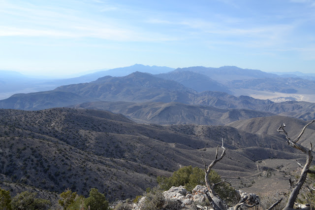
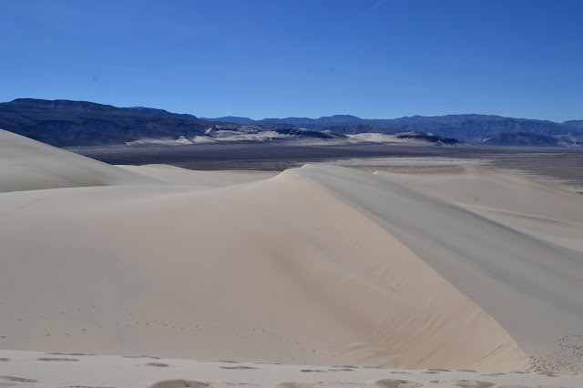
Death Valley National Park It is a good day for a Desert Peaks Section hike. The national weather service had predicted low 40s overnight and I did not wake up in frost for once. Well, I did not expect frost because desert air is good, dry stuff, but in this case it actually is in the low 40s. We are expected at the start point right around sunrise, so we rise ourselves into the pleasant dawn light. After some breakfast and checks and a short drive, we gather for the ceremonial signing of the liability waiver and general summary of the day's activities. The short version is we will walk along a ridge, tag a small bump on the way out, then continue on to the main attraction high above the Eureka Valley sand dunes. We then walk along the road a short way and, picking a spot, strike out into the wilderness. Roads and trails only go so far. Sometimes you just have to pick a direction and walk. This is easy travel country. For now, anyway. It is a long, gentle

Eureka Valley Sand Dunes

Image
Death Valley National Park I spotted a Desert Peaks Section (part of the Angeles chapter of the Sierra Club) outing included on the Hundred Peaks Section calendar and thought it looked fun and interesting. A little investigation showed that they still do not put any of their routes online like HPS does, but the schedule actually is there. Fine time to figure that out as the season for doing these is winding down and there may not be any for a while. As with HPS, you do not need to be a DPS member or even a Sierra Club member to join the outings. I signed up and even found a carpool for the long journey. It would require starting the drive at midnight to get to the traihead on time, so we are actually up the day before and looking about. It is a little warmer and not so windy on this trip to the sand dunes, but then it is the start of spring, not the start of winter. The sand dunes with nothing whatsoever to help understand the scale. Well, there is the little black do

follow by email