Middle Sespe for fall color
Los Padres National Forest
Click for map.
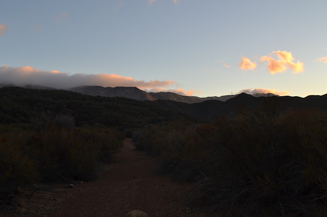
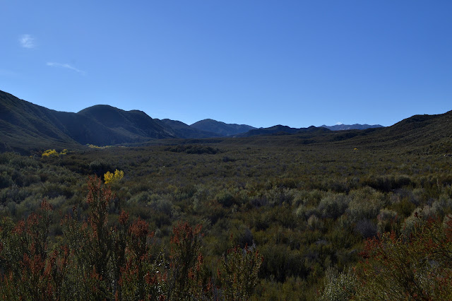
I could not help noticing a bit of fall color as I drove up the 33 last week. I had sort of been wanting to do Middle Sespe once some water gets flowing, but decided bright yellow cottonwoods might be a good excuse to come see it too. It keeps escaping my notice because it seems to parallel the Sespe River Road, and what would be the point of hiking that? I find a turnout about 250 feet past the nearly unmarked trail, or at least 250 feet from the coordinate I have for it. It would have taken a lot of looking without the GPS, especially in the dark. I decided I should treat light like it is important to me and get to the trail as the dawn was breaking. It is a little earlier than planned, but that just gives me time to get my shoes and sunscreen on. There is just barely enough light to walk by once I am ready to hit the trail. I head back down the road to the waypoint. Dirt and rocks have been piled up on the old road down into Beaver, disguising it as just another bit of road edge. Between the piles, a slapstick marker has been placed with an arrow and the words "TRAIL MIDDLE SESPE". Behind it is pavement. There is even a curb on one side.


Clouds are rolling over the mountains to the north. Much of the area well past them is expecting a storm today. I am hoping it will bring cooler air, but promises of low 70s for the high today made last week turned into low 80s as the day got closer. I was only slightly cold as I got out of the car and am quite comfortable now that I am moving. I threw two water bags, ten pounds of water, into the pack to try to be prepared for what the trail has in store for me. Presently, it is more piles of dirt and rocks on top of the pavement with a route around the side. On the far side, the road has turned to gravel. The trail does not rejoin it, but crosses and drops down a hill beside it. It looks like it skips the old campground that used to be its western terminus now.

The trail drops down to the dry Sespe Creek quickly, first splitting into a short cut and the circling route that seems to be official. There are voices behind me, and as I explore the two routes a couple of hunters pass by. Looking back up at the highway, they seem to have found parking a little short of the trailhead. They sound energetic and happy as it approaches sunrise and the time that they can start shooting at things. They clearly have someplace to go. I appear less certain to them because I have my own hunt for a geocache I cannot find. I move on a little after them, a bit more slowly. The trail seems to wander a little before joining up again with old road and I start to think about how nice it should be once there is some sunlight shining through the autumn leaves.


The sun seems to be taking its own sweet time getting into the canyon. This canyon heads down to the east, the sun comes up in the east, it should be here already! Ignoring all the twists and turns and even without those, the sun coming up in line with the canyon would only happen at the right time of the year. So I have to wait just a little longer. Briefly I am distracted from the waiting because I notice the creek is not entirely dry. There are pools below, in sheltered deep spots. Just a bit of dark among the light rocks until the sun can finally hit it, too, and become a bright reflection. That will take a bit longer.


The old road vanishes as the trail starts to climb. The trail thins and in a couple places, I need to test my step before committing to it. The hill is steep, but the trail along its edge is a lovely grade to make the climb easy. The trees below may still have a lot of green in them, but as I climb, it is more and more just the yellow tops that have already turned.
The initial climb on steep slopes yields to more climb on mere slopes with a little winding through tributaries. The second one gives me pause. Does it head up a bit or cross and turn? Cross and turn is usual and there is a geocache just 200 feet away in that direction to help suggest it. I just cannot find anything that looks like trail except the smooth creek bed with slightly encroaching vegetation. It actually is not out of character for the trail so far. Still, I decide to try the other way. Heading up the creek, the dry bed is wide and sometimes there is a suggestion of trail following the right side. Or maybe it is just high water. I go a little further and a little further still. Finally, there is trail climbing out of the creek bed to turn back the other direction and keep on climbing. As I climb, the soft dirt ahead of me seems devoid of almost all prints. There are a few deer, but I must have lost the hunters somewhere behind me.

There is a shot. It comes from a completely different direction than the hunters might be. More hunters ahead? After plenty of time for any missed game to scamper off, there are two more slow shots. Probably something regulated by business hours rather than a season: the Ojai Valley Gun Club. There are actually some low mountains between here and the road, but they are cut by tributaries and the cut by Howard Creek is well placed to let the noise through from the gun club.

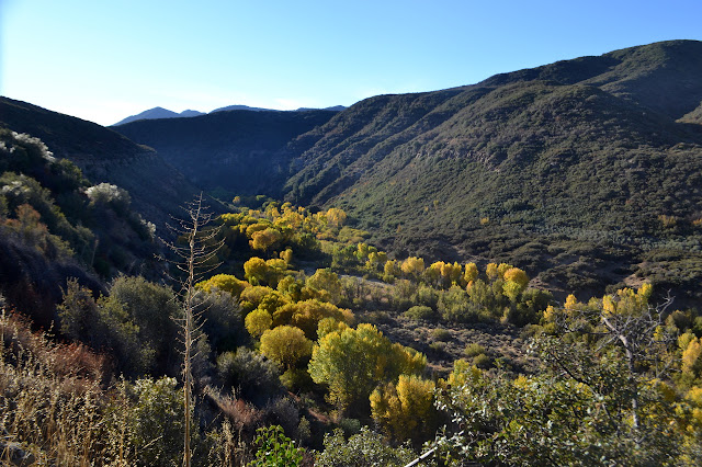
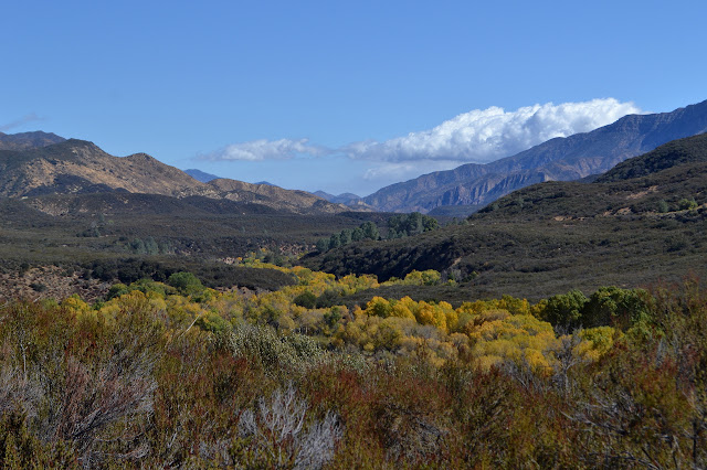
The trail hits a high point among the brush, then drops a little onto a bit of ridge and views downstream. I scan Nordhoff Ridge for the skeleton of the old fire lookout and cannot seem to locate it. It has always seemed so obvious in the past. I could not find it last week, either, although I was sure I should have been able to see it at some point. The view is more interesting downstream where the line of yellow snakes down from the Rainbow Ranch. Another ranch sits just to the south and there is a suggestion of water in the creek between them. Northeast, the mountains hide beneath clouds still, but there are some fun things happening with the light beneath those clouds.


Starting down into Rock Creek, the tread starts to decay. After a pair of switchbacks, it gets really bad. Much of it is a slightly less tilted line along the hill side. I find myself looking for the straighter spaces between sparse plants to decide where it goes. Sparse plants do not make it an easy exercise. Then some scrub oak closes in and the way ahead has no tread and bits of oak growing up less than a foot apart. That cannot be trail. I backtrack to see where I missed a turn. Trimmed trail, then tight scrub oak. There is no place to miss a turn. That has to be trail. So I push through the stabby leaves and there is trail again.


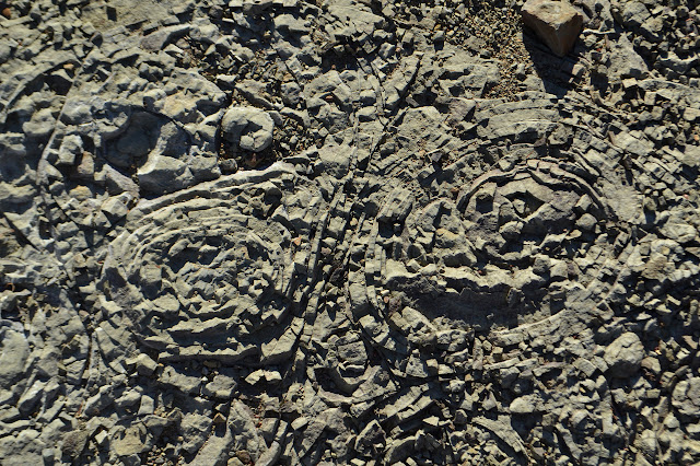
The tread recovers as the trail hits some less slanted land for the last of the drop into Rock Creek. Bare sticks surrounding the trail make me suspect it is brushy in other seasons. It is a slight climb down to the creek itself. Crust around the rocks make it look like it carries a good sized flow steadily, but all the moss is dead now. There is no indication in the creek bed where the trail goes. I scan the far side for trail and come up with a lot of uncertainty. Maybe it is that break just a tiny bit downstream. I cross to it and am still unsure, but someone has placed a cairn up high on a rock to the side of it, hidden by brush from the other side. Someone else thinks this is the trail, too. After the short steep climb out of the creek bed, there is solid tread and a lot of brush to push through. It is just something to deal with until the trail comes out onto the flat and is like road again.


The flat is nice until the path down the side and into the next creek. The scrub oak closes in around it. Initially, the tread looks a bit like creek bed and I am worried I went wrong again. After I have thought about turning back and checking a couple times, it finally takes a momentary turn upward, leaving the flow behind in a 30 foot respite from scrub oak scratching. The tread is obviously tread the rest of the way down, but it is almost entirely a push through scrub oak bringing on fervent wishes for long sleeves. Even the abandoned road last week did not subject me to this. And then there I am, crossing another dry creek and coming out among the blooming rabbit bush at the north end of Rainbow Ranch.

A few more wiggles through minor tributaries, and it is up to more views over the river, this time right across from a tight horseshoe bend. Soon after the bend, I am aware of tracks of users other than deer. A couple fat tire bicycles and a few walkers have been this way. The horseshoe bend does look like it would be a good destination for a shorter hike (or bike, since the wilderness boundary edges along the trail leaving it outside). There are a few more exercises in just having faith that the trail really goes right along the dry stream as it winds up and down and around more minor drainages.


It still gets brushy in places, but at least past the second creek follow, there is no difficulty figuring out the route. Just a matter of enjoying the cottonwoods before turning around.
As the trail gets out on a flat far from the edge, leaving behind views of the foliage, I start to feel like I am only continuing on so I can complete this stretch of trail and say I have done it. White rocks peek through the low spots for each little stream. I could go ahead and visit Piedra Blanca. How far is it from the junction? It feels like something interesting to do once I get there, but not motivation to continue on.

Without actually deciding to turn around, my feet seem to continue under the original direction to continue on until the junction. The sign does not say how far to the rocks. Looking over, I decide that is probably because they are basically right there and start up. I really might as well now that I am this close.

A guy with four small dogs shouts that they will not attack, just bark as they race up the trail ahead of him and I am deciding on photographs. He grabs for the leash of a puppy as it runs by, but the other three look ready to bounce around barking until they become coyote snacks in the event of an actual wildlife encounter. Seriously, dogs should be well trained or on a leash in your hand for your safety and the safety of wildlife. Well, I say should, the law says must. Not that there is anyone around to fine people for allowing their dogs to harass the local wildlife or even educate them about they dangers they put themselves into. He heads off into the rocks and his pack is a little better about going with him than some dogs I have met. As I continue up, I get to thinking that if I set a turn around time, it would probably have been 45 minutes ago and decide there really is no time to play among the rocks, but I could sit and eat with them for a moment. And I do want to get back to the horseshoe bend to play with my ink.

And then I head back. At the junction, the sign says 7.5 miles back to the highway. It is a bit longer. As I empty the first bag of water, I am glad I brought so much. My legs feel better as I start in on it. I do not know if this is because it is gently rising rather than falling or because I am hiking faster. Probably both. The footprints seem to stop a little short of the bend. If they do not quite make it, they are really missing out. Maybe the wind is just better at eradicating prints in that section. I stop on an overlooking rock and admire the reflection in the little bit of water, pull a splinter out of my thumb that has worked out enough to grab, then play with my ink for one of the quicker, but more satisfying sketches. There is still something stuck in my arm that will not pull or scratch out. Arm protection would have been a good idea.

Then it is off to try not to get lost as the trail decides to follow a stream bed and face down all that scrub oak, this time while going uphill and already scratched up.
A little after 5 as I face the crumbling trail climbing out of Rock Creek, there is a single high caliber explosion from the gun club before it falls silent for the day. I have heard they have some interesting things you can shoot for a fee. I am sure it is very satisfying to have a little motion translate into a huge effect, but also very expensive for whatever that was. I cross the creek and push through the scrub oak block and climb hoping to get past a stand of Matilija poppies that mark the last very bad spot. Getting to the top is not so bad.
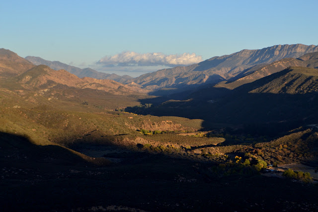

Heading over the top and down again, I wonder what the hunters might be up to. They had a lot of gear. The light vanishes from the valley and then the peaks. Between two hills, I catch a short glimpse of Reyes as it turns red in the last of the light, then miss a switchback in, um, "celebration" of the sunset. The trail is suddenly weird and steep, but there is still room to walk and someone has been here before me recently. I should go back, but it is steep and the end of the day and there is the faintest path that sets me back down on the proper trail.
There are just a few single step bad spots and then I am down in the valley again. There will be no moon tonight. It was new a couple nights ago and now is probably chasing behind the sun so closely that it was behind the mountain before the sky was dark enough to see the delicate crescent. The road is easy to follow in the gathering gloom. An old gate post marks the turnoff for the trail back up to the highway. It seems overgrown. I do not remember it being overgrown before the hill. I check the GPS to be sure, it says this is the way I came. There are stream bed crossings and wiggles I remembered, then more thrashing through brush that did not even register on the way in. I ask the GPS again and it just confirms this is the way I came. It is easy to see where the trail is in the dark with the brush. It is simply the darkest bit below the starlit shrubs. That can be dangerous, but with the light on, all I see is the branches and not the darkness or the trail. I keep it on because I am sure there is about to be some wood to run into. And there it is. With all the options, it is hard to find the trail again after crossing the dry Sespe. I pick a few okay options and find myself on clear trail again for the last little climb to the road.
More time on the trail, but back to the car earlier. It is a private little victory to use all the light. And the tea in the thermos is a perfect drinking temperature as I forget about the scratches and whatever it is still stuck in my arm. It is a far more interesting trail than I expected and the fall colors were a much better excuse to see it than a bit of moving water in the far off creek would have been.
©2017 Valerie Norton
Posted 22 October 2017
Liked this? Interesting? Click the three bars at the top left for the menu to read more or subscribe!


Comments
By the way, just today I was looking through my Math Club files and chanced upon 2 photos, both with you and your sister in them, taken 20 years ago. If you'd like them, stop on by or tell me where to mail them!
Are we holding awards I found in a box a couple months ago?
I found some suspicious black hosing a few years ago on the backside of Reyes Peak, along an unmarked trail from Alamo Creek (near its junction with the Cuyama River) heading up to Beartrap Creek. I cut it with my knife to see what would happen, and it spurted water. Later I heard the feds found a big grow back right near there!
The pics I found are of the Westmont competition - a group photo at the start and a few of the team working on problems.