Peak Mountain and McPherson Peak
Los Padres National Forest
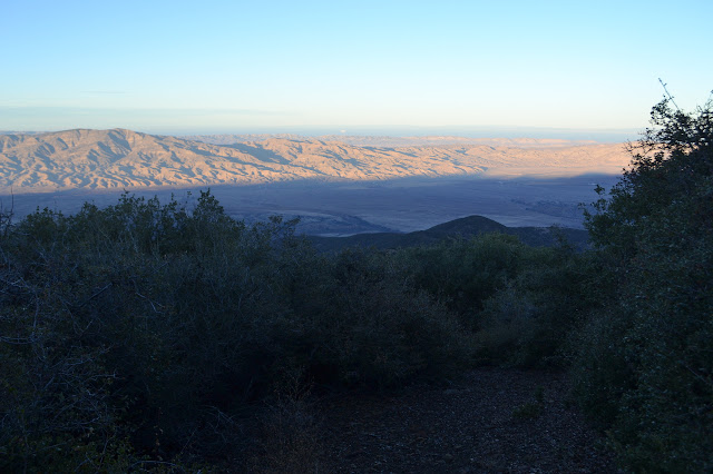
Click for map.
With the aim of doing some sawyer work in the north end of the county starting Friday and being able to get away for Thursday, I looked for something to hike in the area. The options do not seem to be plentiful. There are a couple of peaks on the Hundred Peaks Section list out there. One is practically a drive up and the other actually is a drive up the way they are usually done, but it turns out the drive up has not just one but two trails up it. A loop hike sounds great. I might even go after the near drive up, but it does add a little over 6 miles to the trip which might make things a little long for these short days. The plan is to hike from Aliso Park up the canyon and check out Hog Pen Spring on the way, then head over to a nearby benchmark called SIGN on the map. From there, I can trot over and go up Peak Mountain, or skip that and go directly up McPherson Peak before following the ridge route down. After the long drive, I get a 9 AM start, so a couple hours of light have already been lost.
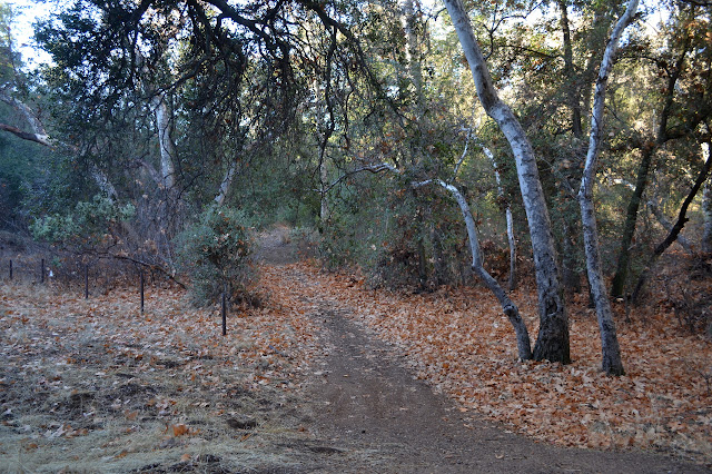
The road is rough as it crosses a creek, then smooths out. Another road splits to the right and curves back the way I came almost immediately. This is the bottom of the ridge route, which I was a little concerned would be hard to find. Although there is no sign, it is easy enough at the start. I am headed for the spring, so I ignore it and keep to the longer road. Travel is easy and when I notice myself relaxing a little too much into the walk, I push myself a tiny bit. If I keep up a reasonable pace, there should still be time to get that other peak.

The road splits and splits and I suspect the spring is off to the right, so take those splits. It goes right through an old fence. A rock arrow on the ground points randomly off to my left, but the spring is in the canyon so I keep right. Up there, there is a full trough, an empty wooden holding tank, and a metal spring box (maybe) that does not look in good shape in the middle of some general seepage. The trail continues upward to another fence surrounding raspberries. Past it, things are a little drier. I am not interested in going all the way to Upper Hog Pen Spring, so turn back after the thorns.


I head down to find the trail that continues from here since this is the end of the road. Further down, I saw the edge of a sign. That turns out to be a "pack it in, pack it out" sign. This used to be a campground. At the end, little trails make their way further up the canyon, but I am looking for something that goes up the side. The cut of the trail is actually quite clear and heading to closer to the spring. I head back up and this time follow the rock arrow on the ground. This is the trail.


The trail is easy and open and sunny, although perhaps a little narrow. And full of ticks. Really really full of ticks. I saw a trip report noting lots of ticks, but that was from April. It is January and there are even more than were noted in that report. I step past some sage and come away with a dozen scattered around my legs, then past some buckwheat and swap those for a different dozen ticks. I can see them clustered by the twos and threes around the grasses that stretch over the trail. They must have been gathering for weeks, but surely the rain would have washed such a gathering away? I take a moment here and there to flick them off, often one with its butt rising enthusiastically into the air as it tries to dig into my trousers. Mostly, the nylon encourages them to drop off on their own.


Reaching the Sierra Madre Road above, the trail is well signed. The mileages on it might be a little short. I turn toward my goal mountains and walk along it. It seems to be Scion ready except for being behind at least two locked gates. A coral and a gate that appears to be permanently locked occupy a saddle. A trail goes up from the corral to McPherson Peak, but I cannot quite find from where. Probably around behind the corral.

I continue on to the junction of Sierra Madre with the peak road and turn away from the peak to walk up the bump. There is a nice fuel break to help me get there without too much trouble or ticks. It makes me rather suspicious I will not find the SIGN benchmark. But up at the top, there is a post and next to the post there is a benchmark and on that benchmark it says MCPHERSON AZ MK. Which is distinctly different from what I was looking for. There are mostly crumbled rocks back the way I came. There are more ridge edge rocks the other way, but nothing seems to have a benchmark. This is one of those times when a bit of map showing the benchmark, which is not quite at the exact top, would be helpful. I cannot find the one I was looking for, but the azimuth mark is a fun find.


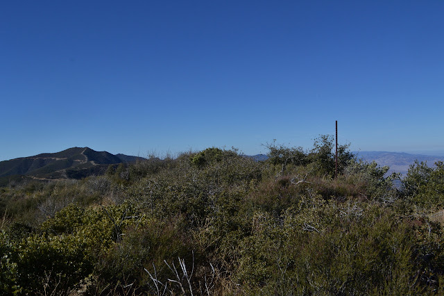
The peak brings with it a view of Caliente Mountain to the north and a bit of shiny ocean far to the south.


I figure I have enough time, so I head down the west side of the peak and start the road stroll out to Peak Mountain, watching for the right fuel break to start up. The sun is dreadfully pleasant and the breeze perfect. It really makes me feel good even if it is not enough to forget the convoys of dump trucks for rocks and the convoys of dump trucks for trash I watched on the way up and why they were headed south. The devastating rains in Montecito were only 2-3" here and there are only a couple hints of new erosion on the trail and road.


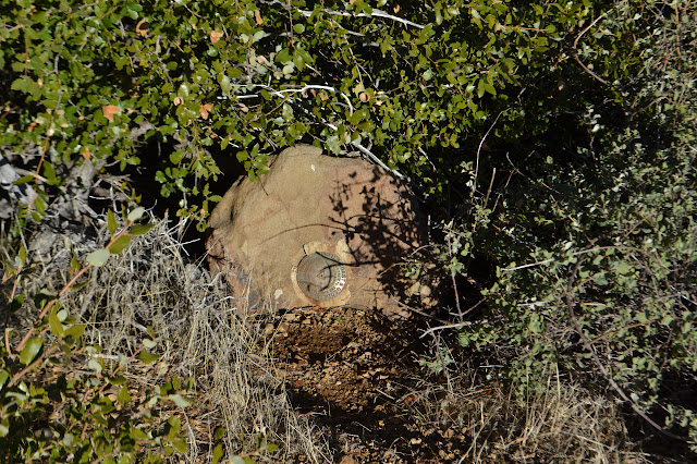
The road walk passes quickly and I come to the east side fuel break of Peak Mountain. Starting up it, there is an obvious trail and frequent cairns to mark the way. This is obviously the typical route taken by HPS groups. It gradually resolves into an old and narrow road, overgrown but skipping the small rocky bumps between the saddle and the real peak. The top is flattened and cleared and not the sort of place I expect to find a benchmark remaining as I step over a decaying post with long wires hanging off it. Surveyor trash. A path into the bushes comes to an open space around a rock topped with a reference mark from 1926. It points right out into the middle of the open space at the top. The station is gone.


I turn to leave and find the station mark apparently staring right at me. It is not so gone after all although not where it was originally placed. It sits in the side of a rock at the edge of the bushes. A second reference mark is down underneath the bushes in a square of concrete, probably shoved there by the same bulldozer. It is caked with mud and all I can see of it is the arrow somehow pointing at the station still.
Heading back down and then along the road and past the SIGN benchmark location is a bit faster than the walk out. At the junction with the road, I decide to go up the fuel break again. It looks like an easy enough slope. There is even a bit of a trail along it. As it levels off, there is a very accurate GPS measuring the movement of the local earth. I keep finding these these things, but they do get denser the closer one gets to the San Andreas Fault. The fuel break peters out as it crosses a shallow dip to the communication equipment on the main peak. Following the edge of the fence around to the north, there is a wide flat area where a lookout once stood. This is the area generally considered the peak. Since the gate is locked at the highway, I get to have it all to myself.


I do not have too long to spend at the top. It is already 4:30 as I start down and it could be dark in an hour. It takes two tries to find the unsigned ridge route down the mountain, but when I do, it is quite obvious.

I thus crown a very lovely hiking day with my worst hiking decision ever because my hike is barely more than half over when reckoned in time.
As I start down the ridge, it is easy to follow. Cairns are occasional, but do not seem needed. An old bit of pink duct tape sticks out on one bush above a mysterious bit of wood that looks like a splintered sign post. Things get tighter as I head down, but there are still cuts on the branches. It gets tighter than expected, and I walk back up to the tape, but there seems to be no other way, so I work my way back down and through it. I find some trail and push through it and find some more and push through it too. The trail seems to hang a bit to the right of the ridge as it goes. This makes sense, the vegetation is thinner there. Unfortunately, there is a bit more yucca. I have to step very carefully through it in a couple places before pushing through some more trail. It seems to somehow get thinner. Even the occasional cuts on the branches seem to become very few. The only real indication of trail are the beer cans. They seem to come every 40 feet. Whenever I am uncertain that people have been here, there is a beer can. I put on my windbreaker against the cool of the night and the stabs of the brush.
The trail has me suspicious, but there is something here. I work down through more scrub oak and yucca. I step through a few of the bayonets that I am sure I could not get back over. As I resort to crawling through under the taller scrub oak for a third time, it is long past time to check the map. Which does not have a UTM grid on it. Or any other grid. I ask Bryan why not, but he is not here to say. Setting the GPS to UTM and following from the ticks at the side about yea far from the folds to locate myself, I am far enough off to be very certain of where the trail is in relation to me. It is quite a ways north. By this time, I am done with making my own ridge line trek along what is obviously hunter trail, and little used hunter trail at that. My brain seems to have turned down the pain signals to the point where I can make it through a patch of yucca without flinching, but they still hurt and I want to be done with them. Heading north means going through thick scrub oak that I can often fit under. At least it usually causes less damage. I am haunted by the memory of being unable to find a way through a patch of scrub oak once before, but that turned out fine in the end anyway. I decide to go for it.
I head off the ridge to the north with some strange hope that I might run into an easy to follow trail. Hope has obviously not consulted with logic. Logic pipes up with the idea that if it goes through the scrub oak, it would be easy to follow because there would just be the one cut to follow. Logic must be infected by hope. The slope is steep and full of soft dirt and I slide under the low branches easily enough. It is not such bad travel. I suddenly find that my hip belt pockets have been emptied. On the left, the pocket has unzipped completely. Three AA batteries I found on the road above and picked up because they are toxic waste are now right back in the environment, but now with 2 AAA NiMH and 2 AAA alkaline batteries added to the poisonous mix. The other side is only half unzipped, but a hole in the pocket has been increased enough to allow the escape of the lip balm. That is one tube almost gone and a fresh tube for when it is. I zip it back up uselessly and go on. There is no way I would find it all again. Watching the endless lights on 166 gives me direction, which seems to keep turning a bit too much west. A bear track turns back the way I want to go and I follow it a while before dropping steeply again.
The far slope looks steep and rocky and not something I want to go up. Further along, it is covered in yucca and not something I want to go up. Working my way eventually to the bottom, the creek bed actually does look good for travel. Maybe it was washed out by the recent gully washer? Two things worry me: waterfalls and eventually having a flowing creek to navigate. The steep slope has been variously soggy or dry as I came down so I expect that there will eventually be water in this creek bed. Still, it is clear and a few feet wide and flat like the best trail bed as I start. A trail for stooped people as the clear area does not extend much upward. And it definitely goes somewhere. Hopefully in a way I can follow.
I take it at a very deliberate pace. It is dark, I do not want to fall over an edge or anything. I wonder if maybe I should stop for the night and wait for some more light than my lamp provides, but I always seem to think it in a wet spot. A wet spot will be a cold spot, so not there, not when there are dry spots available. Although downhill and slow, the walking keeps me surprisingly warm. Maybe the dreading is contributing. Hunger makes me stop anyway and I pull out the biggest object in my food bag: some granola. It feels like sand in my mouth. As I start again, I finally feel the chill from when I stopped, but it goes quickly.
My stoop while walking is relieved and I find a spot to walk comfortably as the creek bed flattens and widens. That, as it turns out, is how to know there is a waterfall coming up. It is short, maybe as tall as I am, and easy to bypass, but nothing I want to tumble down. There are more, all signaled the same way. The tallest of the waterfalls is 20 feet or so and still not so hard to bypass. The most difficult falls into a narrow section of canyon that I decide also needs a bypass, but deer trails to the side help me out. I climb and drop and climb again and drop until the edge of the creek bed is no longer rocky and steep, then drop down into it again.
More difficult than the waterfalls are the few spots were vegetation blocks the path. A sudden crop of willows or some fallen bay trees produce spots that I cannot get through. Bear comes to my rescue for these. He sometimes uses this easy travel route as well and cannot get through either. His tunnel goes around to the side of each one. Usually my knees would protest bitterly at the crawling to follow the bear, but for now they only register that the surface below is rather textured.
As I go along the creek, I have my GPS showing tracks and sometimes check my progress. I am "a bit more than a mile" from the road I came up along. Over and over, it seems to be a bit more than a mile. I feel like it is a couple hours at a bit more than a mile. Slowly, very very slowly, it works down to about a mile away. It seems faster as it works down to 0.8 miles away. Although I see random cut brush far up the creek bed, there is no hint of trail besides the bear tunnels and occasional deer tracks. Now I am starting to see hints of hunter trails. As I close in on a half mile from the road, the hints of trail start to become a path. Certainty of actually getting through this way starts to creep in, but I push it away because too much hope can cause a lapse in attention that could lead to such things as walking over waterfalls. Still, the paths are nice. They are probably from hunters, but much more used than the ones on the ridge. They follow the creek bed, but are not in it. The hunters have taken the time to cut through the brush when it gets in the way. Generally it is smooth and grassy. It allows me to move far more easily than in the rocky creek bed. It is also a fair bit straighter. I close that last half mile much more quickly than the previous tenths of miles.
It seems a layer of brush has been left beside the road and I have to push through that last bit to get off the hunter trails. After the last bit of travel, it is unpleasant to push through again, but I know the road is there and am very willing. Standing where I have been before, I can finally let my mental guard down. Mostly, that means the constant suspicion that there is a waterfall just past where I am looking can evaporate. The heightened awareness of everything that might be trail-like in my direction can reduce down to the simple task of following plain road. I pull on my fleece as I allow myself a first look at the time since beginning the creek descent. It is 11:37. I have one brief navigation scare as I almost take the left as the road splits for the other end of the ridge route, but then remember to take the right only to realize that this is actually a place where the road briefly splits while going past a corral on one side and it did not matter which way I went. At least back at camp all I need to do is make and eat a bit of supper, roll out my sleeping bag, and do a really thorough tick check. I had even noticed a few in the downhill struggle beneath the scrub oak although I was not willing to do anything about them at the time.
So, where did I go wrong? As usual with this sort of thing, there were many places where the right decision might have prevented the undesired part of this adventure. Two were in the planning stage. 1) As I researched McPherson on peakbagger, I noticed a GPS track for the ridge route and briefly thought about putting it into my device. The only time I have done this before was when I had already failed to follow a trail, so true to form, I did not download it for this trip. With this, I would have quickly known when I was going astray on my way down. 2) I thought the ridge route would be easier to find at the top while the canyon route easier to find at the bottom because these are areas where there is limited choice for the trails to be. This went into my decision of direction for the loop portion of the hike. As it turns out, there is a sign at the top of the canyon route and the bottom of the ridge is fairly obvious (if not intuitive) in spite of a log I read about someone missing it and having to come back. Since ridges are easier to follow up, doing the loop in the other direction may have helped. (The signer before the last on the McPherson register did note that they lost the ridge route on the way up and had a 5 hour bushwhack to the top. But I would have been able to skip Peak Mountain and still return at a reasonable hour even if I did the same as they.) 3) Finding myself with about an hour before dark and knowing it would take longer than that to do the ridge route, I could have simply gone back to the road to take the canyon route so I would not be on new trail in the dark. 4) Once taking the trail, I should probably have been a bit suspicious earlier. I can be a bit determined about forward movement and there was trail sign as I went. I did circle back once early on, but the bit of pink duct tape is common to routes where HPS hikers have been so expected I was on the trail. While I did think about turning back to take known trail at this time and later times, it was increasingly undesirable, first for the slope of the trail at the top, then for the scrub oak I would have to fight to get there, finally for the yucca I would have to fight to get there. 5) At any of the times I thought about turning back, I could have, but see previous sentence. 6) Going to Peak Mountain even though I knew it was a bit long and there would be some dark travel. My excuse here is, of course, that there would be this lonely peak on a list sitting there unclimbed. This seems so silly since it is easy to combine with one I was doing and is quite a long drive. More silly is worrying about it since I claim I am not really working on that list. Admittedly, it was the better peak of the day although they both have something going for them in the views department.
Ultimately, I underestimated the difficulty of the peak route in spite of having clues about that while planning. I got cocky about being able to follow trails, even ones new to me, in the dark and I paid for it with a 7 hour ordeal, 5 of them wondering if my forward travel might not come to a halt at something impossible to pass. It could have been worse. Injury was restricted to bruises mostly on my thighs and a multitude of stabs and scratches on my hands and legs and this will heal eventually.
©2018 Valerie Norton
Posted 16 Jan 2018
Liked this? Interesting? Click the three bars at the top left for the menu to read more or subscribe!


Comments
The top portion of McPherson trail after that initial tunnel of scrub oak is totally indecipherable. Farther down the ridge it does pick up the trail coming from Aliso Park. But the upper 1/3 is in need of serious work. Need to get a FS ok to brush it at a minimum.
My blundering down wherever certainly didn't help it become more decipherable. I'm not sure what can be done. Maybe frequent cairns, as long as a kicker doesn't come along calling them unneeded.