Mill Creek to a mortar stone
Sequoia National Forest
Click for map.
One of the Kern area geocachers has been slowly setting a series of "5 Mile Hikes" at the 2.5 mile mark on some of the area trails. It's really quite a nice chunk for a lot of people. I have intended to do a few of them (probably without using the cache as a turn around point) but never seem to get to it. One has been set on a trail I know from attempting to hike up Breckenridge Mountain one day after a snow storm. The top where we were trudging through ever deepening snow and the middle where we were washed with quickly melting snow were not so great, but the bottom was quite lovely. (It probably didn't hurt that our feet were dry when we first got to it, either.) Since I'm familiar with this one, I thought it would be a good one to take Timmy on. Yes, I'm bringing the cat along again. I've devised a way to easily carry him, too, since he is still 19 years old and that's quite old so I don't expect him to walk the whole way.

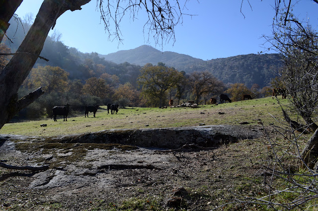
The day starts off foggy and overcast and there is expectation of rain in the later evening, but somehow I still feel hope that the sun might break through at some point. Just not very soon. The area is free range for cattle, so there are fences and the vegetation is changed by their grazing and movement. Grazing seems to be quite a popular thing in Sequoia.


Timmy somehow picks up a tick in the first quarter mile in spite of the chill and season. The squirming creature is easy to see against his light fur and flick off, but it is something to look out for at any time.

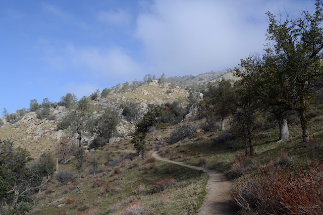

The walk among the granodiorite, similar to but not granite according to a nearby earthcache, strewn hillsides is nice, but the trail name would indicate a creek. The first evidence of creek is dry, but there is some running water a little further along and a sign and the first wet crossing to encourage folks not to destroy the stream bed habitat. It is, of course, defaced with bullet holes.


After a second crossing, the trail does not dally long next to the stream. The time has come to climb. It eventually rises all the way to the road high on Breckenridge Mountain (or it wouldn't have been a very good choice to try to climb it) although the finish today will be long before that. The valley oaks have me worried a bit at first because their brown leaves are so small that they look like live oaks from a distance. Closer up, the distinctive shapes make it obvious that these are just deciduous trees.


Maybe just a smidge of a bit further than 2.5 miles, I am close to the cache. The trail pops up onto a flat section for a short way and there is a decaying bit of fencing in a small square. It is a little off trail, although not quite so far as my search takes me. The cows like this spot, too, evidenced by another concentration of patties and a current occupation by cows.
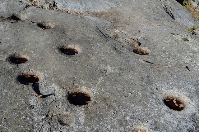
But the people who placed this cache did not just do so because it is a particularly pleasant spot to stop. Or maybe they did, because in their description they call attention to evidence that people may have been stopping here for hundreds of years. A large rock to the east of the meadow is pocked with something like 20 deep mortar holes with another 5 or more shallow starts nearby.

It took so long to come up with the cat that this will be my turnaround after all. I stopped every hour to make sure he got food and water and he's rather slow walking with his short legs. He does like to walk a bit and is mostly happy to do it on trail. Still, there is time for a nice, long break at the top to finally remember to get out the art supplies and let him lounge a bit before returning. He is even more insistent on walking on the return.

After a while, Timmy starts to sit but is a squirming mess trying to put into his ride. It doesn't help that the camera is a bit in the way to get him settled. Somehow, about 1 time in 5, I can get him in right and he'll accept a ride for a little bit. I brought treats, but they only help to get him as far as the treat is away. He just isn't quite as concerned with being down before the dark and the rain. So I try again and again and finally he settles into the moving rest of being carried. When he squirms again, he is willing to walk.

He doesn't notice the distractions he found on the way up. I wonder if that is because he really more tired than he wants to let on. He does somehow manage to pick up a dead tick about the same place he found the live one before. At least its little legs are curled in toward its body and it shows not even the slightest bit of motion. How did he do that?
©2018 Valerie Norton
Posted 27 December 2018
Posted 27 December 2018
Liked this? Interesting? Click the three bars at the top left for the menu to read more or subscribe!


Comments