Lopez benchmark and Vampire Mine
Shea Road (Parker, AZ) BLM
Click for map.
Today is to be a bit less directed than the previous hike, just letting the local hiders of geocaches be my guide with maybe some excursions for a benchmark or Mineral Hill or corners or whatever. The geocaches purport to lie along a loop of road although one lies further afield. One part heads north at the end of 2WD travel according to my map. I'm not sure how this road will look after some rain, but it has been worked recently and is good as far as is indicated by the map right now. For the caches, there seems to be a recommendation for 4WD, high clearance, short wheel base, and avoid weekends for less potential of meeting anyone coming the other way on a narrow rugged road with few pull outs. None of that worries me for walking.

The road does not actually seem uninviting until it starts down to cross the area's major wash. Some people get distracted and drive the wash instead of the road. It looks like the placers of geocaches got distracted too because the first one is also down the wash a little way. It shows off a startling bit of red that runs through this mountain. Much of it is reddish, but this particular spot is like dark bricks. The wash still has some puddles from the last little rain. The road roughens as it begins to climb.

The next cache is somewhere up on the mesa up ahead where the road does not go. The hider indicates it is only a walk, not a climb, to the top where there are cactus gardens. To the "top"... The wall looks rather unbroken and is certainly not a walk. At the bottom of it, there are bunches of cactus. Some people call the end of travel upward the top even if it isn't actually the highest place. I don't have the cache mapped well enough to say one way or another, so I take the gamble that it is below that all too smooth wall and start up a ridge line in roughly the right direction. The little ridge seems to be covered in claim markers.


The cache location takes me to a spot that is indeed at the edge of one of the clusters of teddy bear cholla and about 20 feet from a saguaro cactus at closest approach with a hint about a "lone log". The saguaro does seem to be the only one of its kind on this particular hillside. Unfortunately that closest approach is still 85 feet off. I do what I should have done earlier and drop the cache location on a better map. It is definitely up on top somewhere. The wall does have fissures through it. Maybe it really is climbable. I decide against investigating too closely. I do not even want to be tempted to do such a foolish bit of climbing. It says it's a walk, I will find where it is. Under the cliff, there is something like a walkway, so while not simple, it is also not very complicated to work my way around the edge looking for an easier route up. It is actually a little more troublesome than I expect to move along this way, but I notice that the route back down seems to be improving. Even if it doesn't work out to find a way up, it will work out to make an easier escape. The wall gets higher and smoother before it finally relents a little and then enough to walk up as promised. The cactus garden at the top is not much more than the bunches down the sides, but the log is a little more literal and I can add my name as the second finder in a bit more than 2 years.

Next up is the Vampire Mine. Could it be that rather circular large hole in the side of the wall over there? The map actually shows quite a lot of digging and looking around the place it looks like it has missed some. I head back down, the way the same way I came up past the wall, then down a wash and catch a claim trail up to a big turnout on the road. It is much nicer than a hillside at its angle of repose.

So I start up the road which will eventually take me past Vampire Mine. Here it is most definitely a 4WD road. Claim markers are everywhere. One seems to be for Red #3. Real creative naming going on there. I check out a spur road to find that it gets to a turn around and some wide old trail. I never see the huge circular hole I saw from above along the road even though it looked like road goes right past it. I am around the back side and starting down again before getting to the large holes that are the Vampire Mine.


The loop does not go quite so far east as I guessed, so the mine is actually the last of them. There are first holes that drop down into the mine, then wood debris, then the mine itself. Well, some of the mine. There's actually quite a few more holes and piles of debris to go with it.

I decide I want to head for the Lopez benchmark next. After a little experimentation on the hills on this side of the mountain, I think it will be best to move back around to the spur road and see where that mysterious trail leads.

The trail is old. It has a couple massive palo verde trees growing up right in the middle of it. I can follow it definitely up to a saddle, but not so certainly from there. It seems to be going my way before I lose it entirely. I face cliff walls again, but move around them to see if there is an easy way up. It comes quickly, although then I start second guessing if I went up too soon and will just have to go down again before trying to get up another piece.

It turns out I did not go too soon. I might not have had another good chance to get up past the cliffs if I'd gone very much further. The land rolls up and down a little as I make my way closer coming upon another bit of trail. This is narrower, but seems to hug all too close to a few cactus to have been made recently. I loose it again on the final push upward.


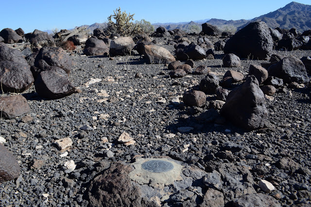
As I get to a distinctly higher spot, there it is, surveyor trash. The remains of some elaborate construction for sighting lie near the station. It is another from 1948 and must have been the same crew. Reference 2 is pointing way off to the right instead of the left this time. Reference 1 exists this time, and almost points at the station. The charred remains of what I took to be fireworks on Planet Peak are here, too. Maybe they were signal flares?
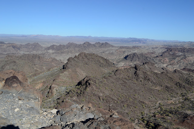
I was thinking to go over to Mineral Hill, but the procedure seems to include two layers of cliffs to get down and the climb looks like a lot of steep stuff on little rocks sitting on big rocks. It does not look all that attractive a prospect to me, especially when I am looking down onto it. I can see that the way down from the saddle the old trail got me to to a turnout near Vampire Mine is a traversible hillside, so I decide to go that way and finish the loop. First, I do go a little further so see if there is a way around the cliffs to the north.

North brings me mysteries in the form of a stone cabin with no roof next to something that is probably a catch basin for water. There is no break in the cliffs that way for a while. I could, however, go all the way over to the next high point where there should be a road that will bring me back to the aqueduct. That doesn't seem like such a good thing, but I'm pretty sure there will be ways to shortcut it back. I can see a couple likely ways on the map. Still a bit long. I head back the way I came and drop down onto the mine area after all.

Turns out I missed quite a lot of the Vampire Mine by turning back after essentially the first hole. There are many tunnels and random digging starts. Most of them don't seem to be littered with rocks on the floor, but I still decide against going inside. There are more tunnels below where the road goes, so I am still missing a few. I follow it out and leave the spur road that goes in to those other tunnels alone. It's getting late, time to hike out.

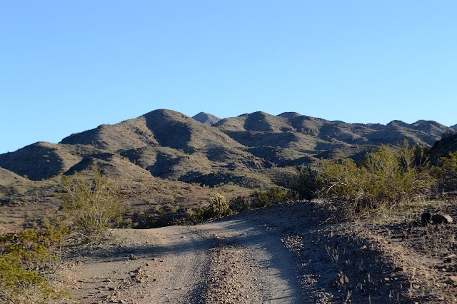
The road rolls along back toward the main road passing another that would take me to Mineral Hill if I still wanted to go. It has washed out spots, but new road finds a way around each. It might be nice enough for just a high clearance, but you'll want your double low on the hill. I notice I am passing by a corner, so take a moment to climb a hill and find it before continuing on.
I spot a road collapsing in 3 or 4 places across a wash which turns out to be the main road. Now it travels in the wash instead. As I pass along below the old road, I look up to see the rusted hulk of an old car. It is actually the first today. Maybe the road is not quite so hard as it looks. It's pretty easy on foot. I finish the loop and head on back.
©2019 Valerie Norton
Written 1 February 2019
Liked this? Interesting? Click the three bars at the top left for the menu to read more or subscribe!


Comments