Planet Peak
Lake Havasu BLM
Click for map.
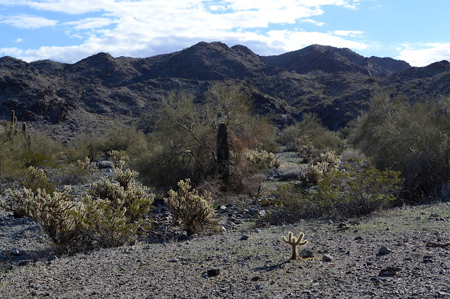
It rises 1500 feet from everything that clusters around it and it says "planet" at the top and what more does one need? Well, maybe a route and there are not a lot on offer for this one. My chosen route starts a little way down the road from a rather nice camp site and, well, I'm already parked, so it starts at a rather nice camp site. From there, head southerly into a particularly large wash coming off the mountain. It will split at some point, take the left side there. A little further and the ridge comes down to a low spot on the left where I want to transition from wash to ridge, then right on up to the top. There is a rocky area that looks a little worrying along the way, but I'll just have to take it as it comes when I get there. There is also a little matter of the weather, which I neglected to get a prediction for and which seems to keep turning the more distant areas a little bit misty. My old weather report for a lot of miles north would indicate it will brighten up a bit, but that is doubly unreliable.

The clouds were spreading in the early morning and seem to oscillate a bit, but as the morning gets older, the wind picks up. A storm carrying a bit of rain tends to break up into wind instead, or so my experience says. But does that experience for a place of undoubtedly different weather patterns hold for here? It will be too late to start when I know for sure so I may as well get going.

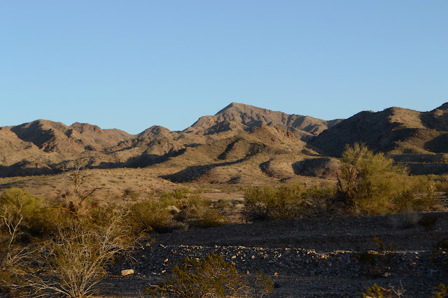
I walk down the road as it plunges in and out of washes until I can't stand it, about the second one, and start cutting across toward the wash that is the first part of my journey. The clouds are actually clearing fairly quickly although the source direction still has plenty to provide. I have not gone far when I find another road, but this one is going my way. It ends at a loop and a campsite just before the transition from flats to foothills.


There is supposed to be a marked section corner on the other side of the wash, so I wander that way to see if I can find it. I wander a bit around and compare the topography on the map with the area and generally get myself into the correct position, but the only thing I can find is a thin metal pipe that has been pounded into the ground. It could be the corner, but it looks more like scratch work. Disappointment, but so it goes. I turn back to the real task at hand and start up the wash. The ground covered in loose and rolling stones is a surface that will reward a toe first stride with a lot less pain. I quickly find some deer trails that are slightly better to walk but they come and go as they please.

The wash holds a couple claim markers and then nothing more of man. The deer trails are about all it holds of animal. The main path of water in the wash is sometimes choked by a bit of catsclaw, but there is always a bit of slightly higher ground that is easy to gain and free of spined defenders. The walls rise quite steeply on either side and hold interesting harder rock formations. The split, or rather joining, is as easy to spot on the ground as on the map for that bit of navigation.


The low spot is a bit harder to spot. I am almost past it before realizing I have come to the right wall. It is still 200 feet of steep. For a bit I think it might really be just up the next little inlet, but that is just a steep, tumbling wash that goes up to a higher spot. One way or another, it is time to start climbing.

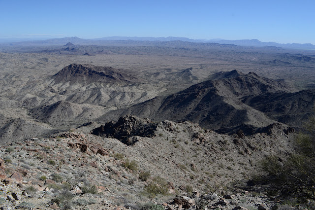
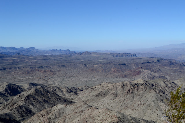
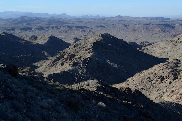
There is a bit of trail up a slide spot, but it seems to vanish quickly enough. I head over to my right, where something a bit like a ridge drops down and promises slightly more solid footing. It is not all that much better, but the other wasn't all that bad either. It is just a trudge and then there is the top. Well, almost. Views start showing up very quickly with the gain of a little bit of altitude.

There's a substantial bump on the ridge behind me and another in front of me that hides the peak. While it would have been a lot of extra work to go over the one behind, the one in front is not much extra at all according to the map. So up I go just following the ridge. All the way, just follow the ridge. All ridges join up to become the top, after all.

The map doesn't lie. Although there is some elevation loss after the peaklet, it is not enough to bother with going around. I get to walk a little, although there do seem to be a lot of big rocks jutting out of the ridge along my route. Deer trails lead around each in the easiest way. Other than the rocks, I get a bit of a rest with the climb for a bit. That one rock at the end of the gentler uphill doesn't look any better than it did from afar, though.


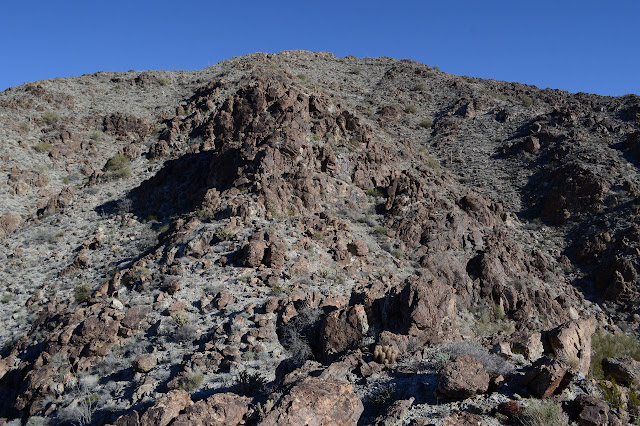
The rock I keep worrying about stands tall and wide in the middle of my ridge and the loose slopes around it are steep. Standing below it, I am only 1000 feet from the top but 500 feet down. The slopes on the left side seems impossible while the right side just seems hard. Maybe I should just climb it. It is not nearly so crumbly as Black Peak was. It just seems uncomfortably far up. I suspect his would be the fun bit for a few people. I go right and scramble into a cleft between rocks and then scramble sideways and up in a way that gets old really fast. There is a fat crack up the rocks that looks almost within my skills and I go for it. It only takes a couple brief moments of intense discomfort with my position to get to the top. I do not want to go down that way. Still, now that I've passed it, only a steep uphill hike awaits. Well, there seem to be a couple very short climbs, too, but none of particular difficulty or worry.


Then there is the top complete with surveyor trash. There is a cairn that seems to be built around something, but nothing in the middle of it but dead bugs. Past it is the station mark dated 1948 and past that is reference number 2 pointing back at the cairn instead of the station. It's actually a pretty big angular mistake. There also seem to be some fireworks or something. Burned out tubes, anyway. I can't seem to find reference number 1. There is even a description of the benchmarks tucked into the register, but it is no help. It has a distance but no direction. The cairn is at the right distance, but there really are just loose stones in the middle no matter how far I dig. And all those dead bugs which must somehow get strained from the wind. I will just have to enjoy sitting above everything else for a while instead.
My peaceful eating and being in relative quiet is suddenly shattered by the sound of a small yellow and orange jet right behind me. It is flying below me, but my thought is that I've seen lower. As that noise dies away, there is a second behind me. His buddy must have had a similar thought. He can do lower.

It is probably time to get going back down. Navigation is always a worry on a ridge, so I fix my eyes on the low spot and make sure I'm in a line to get to it. Somehow there is only one spot that could lead me off and that is almost at the top. After navigation, my only worry is that one rock on the way. I don't want to have to climb down it. I even go around the short climbs I did on the way up after it. Once there, it still looks impossible on the east side which is now to my right. The west looks dreadful, but with a little care possible. I start down it. I seem to keep turning back to get even lower to get around something ahead that eventually I'm not even sure I'm getting any closer to the bottom of the rock. Frustrated with it all again, I scramble upward and a little further around to a ledge and find myself to actually be in a very familiar cleft between rocks. Just a few steps more around and I am back on the ridge line but now with the dreaded rock behind me.
So down I go, checking for that low spot. Is low spot still there? It becomes more of a name than a description. Low spot is still so very very far down for a very long time, but remains faithfully there for most of the route with only a brief time in hiding.
As always, just keep working toward it a little at a time and it gets closer. I go all the way to the spot this time and behold, for there is a trail angling in the upstream direction. A very lovely trail. It is at an incline that would have been very comfortable to climb and is nice on the downhill too. The tread is even comfortably wide. It continues as a beautiful thing until running into a small slide area where it starts to cross, but then takes a wiggling and steep downhill. It is the exact trail I started up. It had always been here for me if I had only looked to my left instead of looking for a place to scale the slope to my right.

Now that I'm in the wash, all roads lead where I'm going, give or take. So I go, stepping carefully as I do.

The camp at the end of the road is easy enough to find by keeping mostly left as I exit the canyon into the flats. This time, I follow the road down before turning and walking back to my parking. It is probably a little longer, but doesn't feel it.

©2019 Valerie Norton
Written 31 January 2019
Liked this? Interesting? Click the three bars at the top left for the menu to read more or subscribe!


Comments