Telegraph Ridge
Yuma BLM
Click for map.
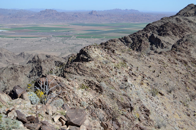
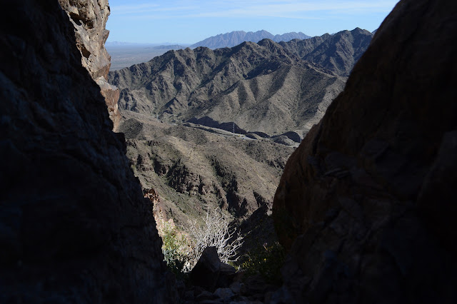
Morning brings much cooler weather and a lot more time to do a bit more hiking. I expect it to get hot again, "same as yesterday" always being the most likely true weather report, so load in a bit of extra water. And since I don't like to repeat things so much, I figure I'll go up along the ridge looking for the high point and come down on the trail across the canyon from the road. I expect the start for that is just to start up the trail toward the cross. Asking someone to be sure only elicits that it probably is, but someone on something, probably Alltrails, says the trail is rather faint. Well, ridges aren't hard to follow, although following them is often just half of the story. That is certainly true just across the river.

The trail is steeper than it looked to me and gets steeper. There are choices along the way. I'm not sure I make the right one, but I can keep my footing all the way up, so it works out. It looks devoid of life on these rocks, but there are bright little daisies the whole way. At the top, there is a lot of downhill. That includes in the direction of the ridge. I think I can see a few trails coming up to the saddle below, so there were probably a few choices that did not include the extra little peak.


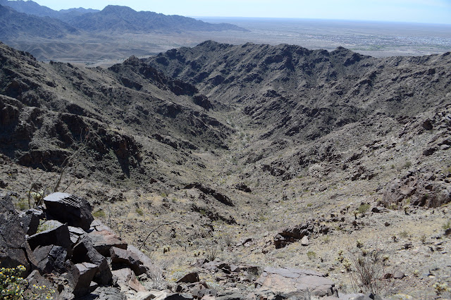
So I scramble down the back of the peak as best I can. It is rocky with some very short down climbs. Well, down scrambles. Then I start climbing again. Other trails do come in from the sides at the saddle and more come in from the left higher up. Trail is pretty easy to follow and kindly goes around the subpeaks. Of course there is trail up all of them too, in case you need that one more bump on your way to wherever you are going.

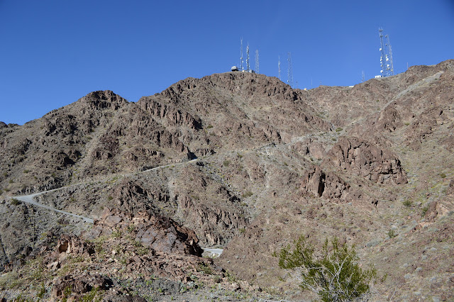
Well, at first the trail goes around the bumps. Nor are all the trails around much easier than just going over. Trail drops to get past cliffs and then scrambles up a loose rock gully a couple of times. But the cairns and sometimes a ribbon continue to indicate where it goes and it climbs and drops and climbs some more to one last peak with some sort of monstrosity perched on its top.


I pass a cave that turns out to have a register in it asking folks who pass to "leave their mark" and a few people have decided to take it to mean on the caves rather than the book. That is fine for the hand prints in the sand, but not so much the scratchings. The last of the major climb gets into the top of a wash. I lose the trail in it, but make something up where I want trail and eventually find it again. The monstrosity turns out to be quite a lot of lights taped to a pole so they will shine every which way and a few solar panels to power them. Presumably there are batteries somewhere too. I did not notice it as I came down the hill last night. That could either indicate it doesn't work anymore or I just wasn't very observant while looking out over all the city lights.

The two miles to get here have been decidedly hard and it looks like there are a lot of big drops coming up to keep it hard. It is tempting to retreat to that wash I just came up and drop down it. That looks easy. I can tell it is part of the one that comes out at the bottom of the road. If I still have enough water, I could just go up the usual way. And yet, the antennas are only a mile distant. I managed this much, what can another mile hold?


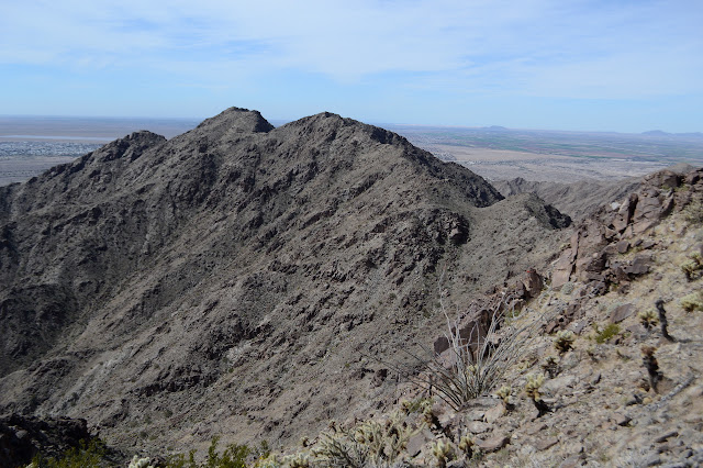
It can hold cholla, but not in a density that is too greatly annoying or difficult to pass. The path is fainter and there are no more cairns, but there are fewer false trails. A line of rocks goes across one that looks tempting to me as it goes around instead of over when it is obvious I will just have to go down again. Turns out, there is a reason for the rocks. It gets around the side and ends in a cliff. Up it is. And down. The trail gradually looks more like a sheep trail, but it finds a way around instead of over the sharpest portions of ridge.

I find myself following trail along the backside of a peaks topped with a big cairn. It is what I expected was the high point, looking out from the end of the facilities last night, but was actually a bit past it. That is to say, it is still to come from this direction. Up ahead, there is a side peak also topped with a cairn. The high point is where it breaks off from the main ridge line. Clearly, the cairn topped peak beside me is a popular destination because trail suddenly becomes a lot wider as I return to the ridge line.

Having gone just three very slow miles, I reach the top. It has no cairn, but there is a broken glass bottle that is trying to serve as a register. It occurs to me briefly that the other peaks might have cairns because people think they are better spots to look out on the world from. They might be. I am ready to finish off the ridge walking part of the hike. I watch smoke come up off some of the farms below and try not to worry because it looks like it is actually on purpose.

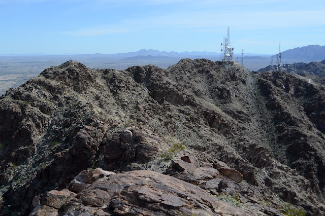


I head down. The trail is quite easy to follow once I get off the peak. The ridge is quite narrow for a short section. Peakbagger has another peak marked at the high point among the antennas. It looks at first like it is under a Border Patrol antenna, but is actually a bit north of that. The north slope looks like a bad scramble, but beats trying to get around hard hat area if this is a peak you want to tag it. I certainly won't bother again. I leave it quickly for bobbing along the road to the register and the top of the trail down the canyon.


I am not quite done with ridge. There is one more thing I didn't do the day before, which is go out to the arch that happens to be almost a quarter of a mile along more of the stuff. There is trail for it, too. It is almost easy to follow throughout.

It's an odd sort of arch, very square. I sit behind the arch in the shade and look out at the roadway below, but when I actually sit within it it is quite hot. The rocks must have been warming all morning.

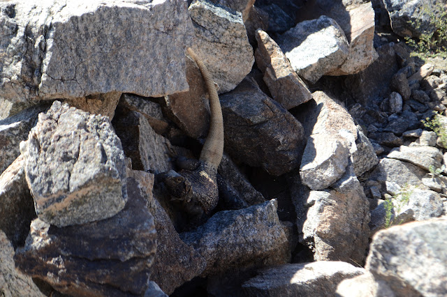
Then I head back to the register at the top of the trail and down. I expect that is where the race in April will be marking the turnaround point. The trail is as steep as it look, but it must be a built thing. There are even rock steps constructed in some spots. And there are gila monsters! Not really. They are chuckwalla, as promised, hanging out in the rocks along the trail through the canyon where they live and scampering away at the sound of a hiker. There are also promised elephant trees, but I had neglected to notice that on the sign the day before and just keep on noticing that the short feathery leaved tree doesn't seem to have any claws although it certainly looks a bit like catsclaw. The bark is actually quite different.

Once trail and road are near the bottom of the canyon where it is much less steep, there are a few trails over to the road. The trail itself climbs and drops a bit as it is working along a steep canyon side with spots of cliff. The road is flat and easy in this section. The trail ultimately crosses and climbs up behind the sign with the flora and fauna information, but there seems to be nothing to point it out. That does make it easy to miss. I cross the road over to the trail in and take it out. There is a fork along the way and clearly many have gone left, so I try that for variety. It joins with more road for a fairly easy route with a little hill back to the parking areas.


©2019 Valerie Norton
Written 7 March 2019
Liked this? Interesting? Click the three bars at the top left for the menu to read more or subscribe!


Comments