Posts

Showing posts from April, 2019

sketches

Image
I actually sketched a few times last month. Okay, one was actually from March, but it's still better than the previous months. I stopped on my way back along the roads in the Goldfield Mountains to sketch. I studied the terraces a little more on the way down from Silver Peak. I rejoiced in the apple blossoms while hoping Timmy would nap.

Dragonfly Route

Image
Gila National Forest Click for map. There are other destinations to be had starting at the Dragonfly Trailhead, but the claim to fame is clearly the petroglyph somewhere along a loop of trail a little over 4 miles long. This is still in the area that was once cavalry pastures for Fort Bayard but is now administrative pastures for the Forest Service, so is well fenced around the edges. The shape of the petroglyph is repeated along the fence as decoration, so you'll know what you're looking for if you choose to try to find it. A sign on the gate warns that the area is under surveillance to try to catch vandals because it is getting abused. It has the only mention of how to treat the art site: look but don't touch. Yes, even petroglyphs degrade too quickly under a constant stream of people walking up, stabbing their finger into it, and shouting to the rest of their group, "Here it is!" Gate at the start of the trail. There is a dragonfly to the left on th

Big Tree and some Knobs

Image
Gila National Forest Click for map. The pastures of Fort Bayard, where cavalry were once stationed, seem to now be the administrative pastures of the Gila Forest, although it is questionable if they are used as any such thing now. Upon them sits an alligator juniper of such unusual proportions that it has been placed on the map. The "big tree" is only 1.5 miles along the trail from the Big Tree Trailhead, but I have found some other map markings that seem worth at least a brief visit and will stretch the trip out a bit. The large and empty gravel lot has two trails leaving it, one generally north and one generally west. The one generally north is the Big Tree Trail, so I head out on the one generally west. My first major stop will be Signal Knob, but there are some benchmarks along the way I'd like to visit so long as they are not too far off trail. The trailhead includes gate and fencing to keep the horses, if there are any, out of the lot as well as nice si

Burro Peak

Image
Gila National Forest Click for map. Time for some firsts, at least as far as I can remember. My first miles on the Continental Divide Trail and first New Mexico peak. Neither of them very big. Burro Peak stands just over 8k feet and the peak is just a little way off the trail after something more than 4 miles from the trailhead near the highway. The peakbaggers say I can drive a long road braving sand and rocks to make the hike about 1.6 miles, but that sort of thing just makes it seem smaller and less meaningful to me. Anyway, this bit of trail actually follows the divide, after an initial scurry over to it, then on up to the peak. Everything drains to the Pacific on the left and the Atlantic on the right (while headed north). Jacks Peak CDNST Trailhead sign. Jacks Peak is slightly closer, shorter, and topped with antennas. Those searching for a shorter hike use the service road. So I start the gentle climbing. The divide isn't all that high around here, in a rela

Basin and Snowshed Loop

Image
Coronado National Forest Click for map. Even though I know the "parks" around here are just saddles, I have this urge to go up and see Pine Park. It's just 3 miles along, just past a junction at the ridge. For a little extra incentive, there's a Fossil Saddle and Fossil Seep a half mile the other way. It's the way I would have gone up had I done Chiricahua as a day hike instead of a backpack . And I might could just make a loop out of it and maybe get some different viewpoints of Cave Creek Canyon. Maybe. I'll get to the top and decide. I would have waited another day to let my poor legs rest a little more after the 32 mile overnight backpack, but the storm that started as I was finishing put down a bit of snow all over the higher elevations and I wouldn't mind getting up there while it still is. Starting at Herb Martyr just like for the loop past Ash Spring , I head directly across the campground to the large sign across the creek skipping that

Cave Creek: Showshed, Chiricahua, and Flys Peaks

Image
Coronado National Forest Click for map. Start with the FIRST DAY  << (Day 2 of 2) I have pudding with chia seeds and pecans requiring no cooking to eat, but I want some hot cider so I have to pack up camp first. There just isn't a single bit of flat area not already occupied. The rock wall I am below is interesting. At first it looks like a bit of old river bed, but it is actually volcanic with minerals leeching through. I'm not sure what the structures I took for rounded river stones at first are. The "impact crater" is where the water lands as it rushes over the top of the rocks in the rain. The spout is dark from water stains. Back along the crest are many patches of snow including some in among the bigger tuft of trees near where I first thought about stopping for the night. Plenty of little snow patches for emergency water. The first possible camp was the saddle two humps back. The trail travels on the other side of the humps. My first go

Cave Creek: South Fork, Horseshoe Ridge, Sentinel Peak

Image
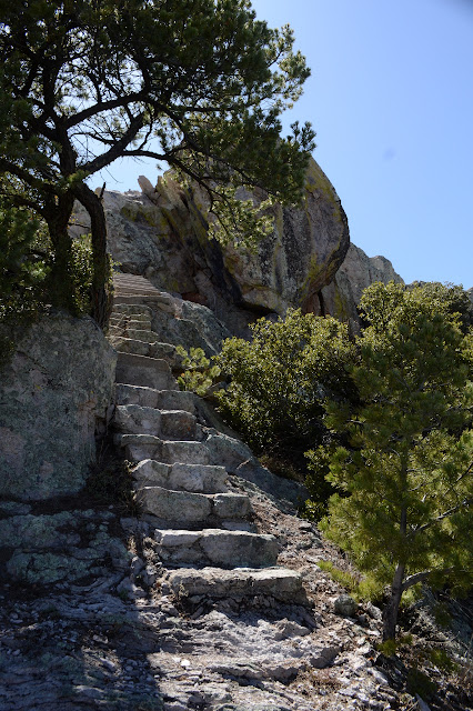
Coronado National Forest Click for map. (Day 1 of 2) By my estimate, it would be 20 miles to go up to Chiricahua Peak and also go for the Chiricahua benchmark on Flys Peak in a tidy little loop going up Basin Trail to Snowshed and down Greenhouse Trail. This could be done, but I'm not quite feeling like a 20 mile day and there are some more things along the way that might be fun to hit. Of course, just hitting the peak via the shorter of the routes (probably Greenhouse) would bring it down, but then there is even more I am missing out on. But then I found an overnight kitty sitter, which opened up some options. In fact, if I could get a ride over to South Fork, that would let me go up Sentinel and Finnicum Peaks, estimated 18 mile round trip on a loop, as well. Then I noticed at 4AM that I better get going today because the kitty sitting offer wouldn't last forever and Wednesday has a 10% chance of rain to make it a bit dreary as a hiking day. So, finally packed a few

Ash Spring

Image
Coronado National Forest Click for map. The loop, generally on the Basin Trail, past Ash Spring seems like a good one to try to get Timmy more familiar with being on trail. It is just three miles long with the spring about halfway with a nearby apple tree for taking a long rest, perhaps. Maybe a nice middle of the day nap is what he needs to keep going. (Odd, what things can be found marked on OpenStreetMap. There seems to be another apple tree on the South Fork Trail at the spot it gets bad.) There are two lots at Herb Martyr with trail parking above and walk-in campground parking below. Currently it is officially dispersed camping, but there are still tables and a toilet for anyone to use. Actually an access trail to the Basin Trail. I wonder what destination has been removed from that sign? I start down the trail, which winds around the far side of the camping area across one old foundation and down a set of stone steps to Cima Creek below. It has good flow and a lo

Silver Peak

Image
Coronado National Forest Click for map. I'm not quite sure Chiricahua is a reasonable distance for a day hike from this area or if I'll have to move around for a different approach, so for now I'll start a little smaller. Silver Peak was the site of a lookout tower and has a trail rising 3000 feet in 4.5 miles going up it. That's a very reasonable day hike and it could put me on a much better overlook for the canyons than the short thing done yesterday . The start is easy to find by the big carved wood sign information showing an area map and Smokey and various other very Forest Service things. Although no road signs show this is a trailhead, smaller signs give quite a bit of information about the two trails that are here. Just past the visitor center is an information turnout and trailheads. The nature trail is most obvious, but through the fence is a little track. It is delightful not to have to fiddle with a ranch gate and instead step a bit to one s

Crystal Cave route

Image
Coronado National Forest Click for map. If you want to go into a cave, then stop right here because you can't get into Crystal Cave without at least a chat with a ranger way down in Douglas. It is locked up and left a bit obscure although the trail to it is the only thing on the map. Across from it is parking for the Snowshed Basin Trail that connects Snowshed and Basin Trails. Or maybe it's the Herb Martyr Trail. They sign actually says "Snowshed Basin Trail / Snowshed Trail / Basin Trail / Herb Martyr Campground / Road 42" which is a lot of things to be, but none of it has arrows. Oh, and there's a warning about entering a burned area because this part of the forest burned not too many years ago too. It would be nice to get away from burn, but it's getting harder and harder to do. I turn around and there is a clear, narrow trail. It passes a blank sign board on its way to places unknown. The signage is for other trails and destinations. Si

Cathedral Overlook

Image
Coronado National Forest Locate the view point. I took off to a new sky island of the Coronado National Forest. This one is called the Chiricahua Mountains and as I was roaming the map I noticed "Cave Creek". Obviously I had to go there. I also noticed the Chiricahua National Monument in one corner, but somehow "Cave Creek" has just a little more appeal. In the visitor center, one woman says she's here for the birds, " obviously, " like there could be no other reason to come to a place like this. The fellow there recommends everyone stop by the overlook just down the road where you can, after a hike of a few hundred feet, look up a few of the canyons and "see why it's called Cave Creek." It doesn't take much time, so why not? The overlook is actually Cathedral Vista. Cathedral Rock is one of those down the canyon, probably a little more left of what I've captured. You can look up the canyons rather easily. The south f

Round the Mountain Spring

Image
Coronado National Forest Click for map. Round the Mountain Trail has been left largely undone, and even if I don't really want to go all the way to Columbine (17 miles one way) as a day hike, I could go out and see Round the Mountain Spring where I was proposing to have my first night. It does sort of illustrate the problem of even wanting to deal with backpacking with the cat that I couldn't even get as far for a first day as I can for a day hike. Still, I don't know what he would be capable of if I were to just let him get more familiar with the idea of moving along a trail. Anyway, today he won't get any practice as I try to get some miles in, see if Marijilda Creek is passable or not, and find out what sort of camp I chose before marching right back. Information at the trailhead covers both camping and the trail. It certainly is easier to go ahead and take a photograph without wrangling a cat, but I still forget to get one of Noon Creek, which is ru

Mount Graham

Image
Coronado National Forest Click for map. The same caveats apply as when I was looking to backpack the mountain except now I have seen evidence that the map creator did know a thing or two about the local trails, since some that are part of the "trail system" are missing from the USGS base map used, so thoughtlessness or ignorance in the creation seems less likely. There doesn't look to be all that much snow, but plenty in spots, so I'm heading out with the same microspikes that call themselves "crampons" that I used yesterday for Heliograph Peak. While it saddens me to take the usual route up when I could do something extravagant, I can at least change it up by taking the trail down to Hospital Flat on the way back. I only pulled to the side of the pavement to park, but it is wide enough for travel and parking both. It also seems to have been a place snow was plowed to and a couple campfire rings have been built right in the middle of it, so it see

follow by email