Heliograph Peak
Coronado National Forest
Click for map.
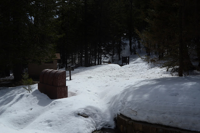
There is both trail and road up Heliograph Peak. The trail climbs up from Arcadia National Recreation Trail near Eagle Rock, not that it can be found on the National Forest quad. My initial plan was to start at the lower end of the trail at Upper Arcadia, but got lazy or loop happy and am at the upper end at Shannon Campground. The campground itself if actually locked up tight and under a blanket of snow, but there is parking a few feet up the road to Heliograph Peak, which is next door and also locked tight. I could bring my snowshoes for the snow, but have decided to go with the easier to carry rubber and chain "crampons" since it is a bit compacted and I am lighter without big pack and cat. They actually say "crampons" on them, but are more like spikey tire chains for my feet. They are too big for any of my shoes except my boots, so that is what I am wearing. Anyway, it seems like the right environment for waterproof boots. I can't get the debris baskets off my poles, so no snow baskets for me. Once sorted, it's down the campground road hoping the trailhead isn't under too much snow to see.

My start is hailed by a chittering squirrel with a decidedly red tinge to its underbelly. One of these rare red squirrels? A sign along the way says Rumex is a rare rhubarb relative that thrives in the local riparian areas and asks if I can find it. Not yet, but the stream is running, so that is probably the riparian area where one should look eventually. Halfway through the camp is the trail. The kiosk seems to have melted the snow around it, so it is not too hard to find.
The sign assures me it is only 2 miles to Heliograph Lookout although that is not actually a destination along this trail. Noon Creek Ridge Trail is in 3 miles and Arcadia Campground is in 5 miles. It would have been about 5 miles from the bottom trailhead to the peak, so 10 miles round trip instead of 4. Now the challenge is to find the trail. It seems to be along an old road which shows up as a wide flat strip on the snow covered hill side. A few trees have come down over the winter and maintenance, if it comes, is still at least a few weeks off. A lot of them are still green.

It does not stay on the old road, or at least does not continue to be road width, after a bit. It also does not stay covered in snow, so I get a few confirmations that I am picking up the right clues and on the right track. It is annoying since I have to take the "crampons" off and on. One long steep hill side makes me quite happy to have them, all the same.

I find myself following some very faint clues about where the trail is under the snow. A long line where the layers show and the trees around seem to be missing in a line works for a bit, but then even those clues dwindle down to nothing and I am certain I have lost it.
According to OpenStreetMap, I have indeed missed the trail by a little, but it has put me in a good position to climb up to Eagle Rock, which is just a shoulder off the trail junction but also on the Southern Arizona Hiking Club's peak list. Seems like it's recommended! The Forest Service says I've actually missed the trail by quite a lot and it travels over the shoulder lot further from Eagle Rock than that, but otherwise I could probably get there quickly from here.


Following the shoulder up the mountain a little way, I find a very shallow saddle with the trail passing through it. OpenStreetMap is correct and the Forest Service is only very approximate. East of the saddle is a tangle of fallen green trees that have just missed the junction of the rather official looking trail that is completely missing on the Forest Service map.

The trail up Heliograph flirts with a little snow as it climbs along a ridge. It can be hard to find in a few spots, but I can work it out eventually until it starts crossing a large snowy bowl full of young aspens attempting to claim all the ground for themselves. Or probably itself, since it is probably the same tree repeated over and over again from a huge system of roots. At this point, I just cannot see why I should bother to try to follow the trail and simply start climbing through wider spots toward the top.

Finally, I hit the road at the top. Tractor treads show in the snow on it, so someone must have been desperate to get up here for one of the towers. The only one I care about is the old fire lookout which seems to still have its complement of shed and living quarters down on the ground.


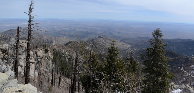
I wander around the buildings a little before heading to the lookout and the high point just past it. There are a number of signs about the history of the area and lookout directly below it. I make the mistake of actually reading the sign next to the steps where it asks me not to climb it. Looking up all those stairs makes me dizzy, but that is exactly what I was just about to do. They travel up to a trap door in the cab rather than to an outside railing, so the steps are probably the only thing that is accessible. Another sign says this 99 foot tower is the tallest in the Coronado National Forest.

I head back along the road. Between how flat and low slope it is and the tractor treads over any snow on it, I do not feel the need to put the "crampons" back on and it quickly runs out of snow anyway. The trail came up not much further along than I did.

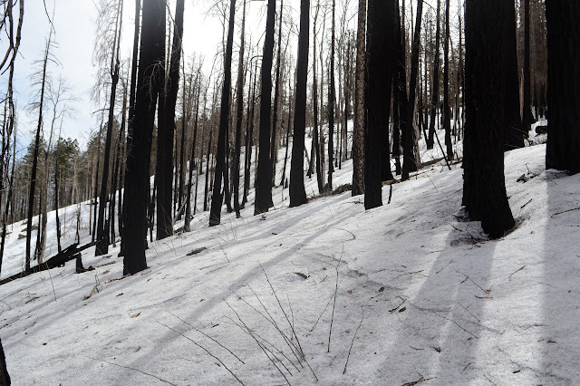
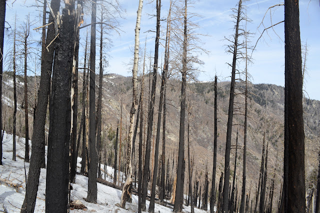
Most of the road path seems to be burned, especially at the top. Three deer on the road startle and two take off with their tails high. The wide, fluffy white is quite different from the mule deer. I finally get to see the common white tail. The third stares at me a while before following suit with white fluff flag flying. Lower down, water is flowing under and over the road in a still snowy cleft in the mountain. Nothing the waterproof boots can't keep out.


There are no trees to jump or anything so the road is a fast way down as well as better directing me back to the car in one of the spots just before the gate.
©2019 Valerie Norton
Written 19 April 2019
Liked this? Interesting? Click the three bars at the top left for the menu to read more or subscribe!


Comments