Round the Mountain Spring
Coronado National Forest
Click for map.
Round the Mountain Trail has been left largely undone, and even if I don't really want to go all the way to Columbine (17 miles one way) as a day hike, I could go out and see Round the Mountain Spring where I was proposing to have my first night. It does sort of illustrate the problem of even wanting to deal with backpacking with the cat that I couldn't even get as far for a first day as I can for a day hike. Still, I don't know what he would be capable of if I were to just let him get more familiar with the idea of moving along a trail. Anyway, today he won't get any practice as I try to get some miles in, see if Marijilda Creek is passable or not, and find out what sort of camp I chose before marching right back.

It certainly is easier to go ahead and take a photograph without wrangling a cat, but I still forget to get one of Noon Creek, which is running quite nicely. It is a brief, less burned area before getting out onto the ridge where darkened skeletons still stand.

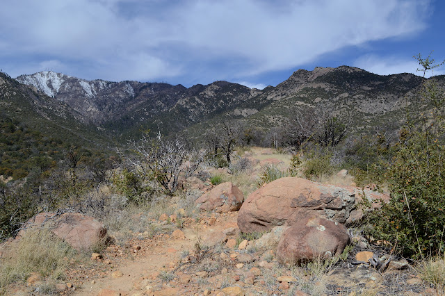
So I climb up as I did before taking the right at the signed junction and climbing to the saddle above. Lots of people have been on the trail, but few have gone all that far. One made it all the way to the saddle and seems to have not figured out the ranch gate. It is twisted up in a way that makes it almost look safe to step over the barbed wire. I think I'll just unlatch it again instead then try to fix it a little. It might be doing something. I saw some cow prints on Ladybug Trail after all.


Marijilda Creek still roars as I step over the ridge and start down the other side. One thousand feet down and all that noise. The view of the canyon gets better a little way down the trail, but even the one that battled the gate did not bother to get that far. Soon I leave behind my own tracks. Needless to say, the maintenace problems above do not get any better as the trail drops down, navigating around the large rock slabs that occupy this side of the canyon. At least the trail bed is generally good and it's much easier to ignore the shrubs and push through without a leash to handle.
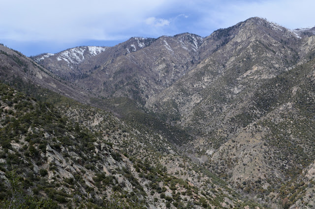


The creek is even louder once down near it. There is a small camp in a rock overhang just before the crossing. It seems like a place that would amplify the roar, but it is actually just a little bit quieter. Trees are down at the crossing and I go toward the creek only because it is the only way to go, not because it looks like trail. Ah, but there is a cut tree, so, yes, this must be it. The only passible thing on the other side is a steep bit of small wash, but as I examine it there is another tree cut. The crossing is actually just above the big white water I was seeing before from above. There might be a dry foot crossing a show way up the creek, but getting to it would be very difficult. Microspikes and creek crossing shoes would have been a better weight investment than the snowshoes for the failed backpacking. Lighter and easier to carry too. Since I didn't get any creek crossing shoes today, either, I need to choose wet shoes or pained feet as they settle into the spaces between the rocks. Somehow after the hike up Evolution Creek with each crossing being so distinctly colder than the last I am not too worried about the cold this far below the melting snow.

I choose uncomfortable feet and they certainly are. It takes a while to place each foot so it isn't too uncomfortable, so they are quite cold by the finish. I'll probably go for wet shoes on the way back, but that is with fewer miles to go than now. My trail runners do not dry in an acceptible time if I just plunge in, socks and all. The trail up out of the creek is not too bad, but the portion out across the grasses seems harder to see now than it was from high above. Some of it is debris on the trail and I start chucking as much as I can off, right up to some full trees made light now that every drop of moisture has been purged from them by the sun. I'll have to be back this way, so the energy spent now will mean less energy spent then and if I don't, who will? Anything that directs feet away from the main track must go!

Something stinks in a nearly familiar way and there is something almost like white thorn ceanothus bursting with flowers. That would be it. The thorns seem a little bit less, but few ceanothus can quite reach the savagery of white thorn.

Getting to Gibson Creek means a sudden downward plunge and then a climb back out again. It also has some plates of rock to avoid. The crossing is nearly good enough to keep the feet dry. Approach to it is made a little difficult by the furthest reaching branches of some fallen alder.


The trail up the ridge is marked, sort of. Most of the sign has split into pieces and dropped to the ground. Cairns mark the way after it.

Apparently I am now headed toward Marijilda Picnic Area and the trail is much better, at least for the half mile to the junction where one of two signs burned. Climbing again after it, I keep finding rows of flat rocks placed at an angle to the track and being glad I'm still on trail because there is a water bar. Say what you will about the effectiveness of a rolling dip, no one will be coming to one and suddenly feeling confident they are still on trail.


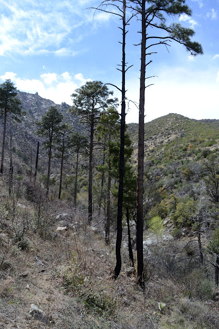
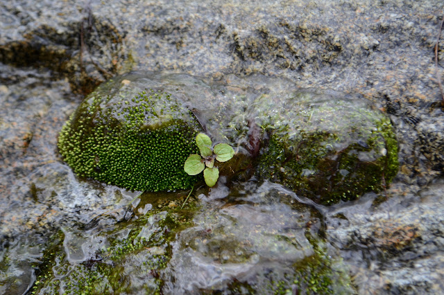
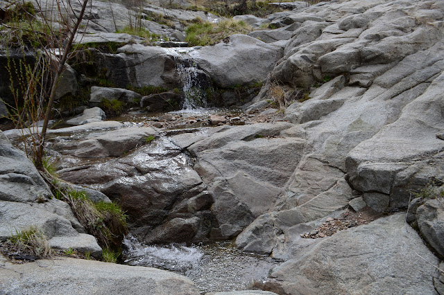
The spring is shown in a little stream and there are spindly trees in a canyon as I approach. The fire was here, too, but didn't get everything. The approach also includes something as tall as I am an full of very long thorns. Perhaps technically not thorns. They have no leaves, but it sure looks like the vicious spines of roses. The ceanothus might not be so bad, but these sometimes inch long spikes look like they far exceed our wild roses.
It is a pretty little stream in places as it cascades over the granite bedrock. My attept to walk up it and find the spring comes to nothing. There is some seepage just above the trail and creek bed before the crossing. The stream water seems to mostly be coming from far above. I settle on the rocks and snack and ponder for a moment maybe going all the way to Deadman Creek, which was 3.5 miles from the last sign.
So, if I had pushed on with the grumpy cat and got here, where would I have slept? There are certainly no candidates for a campsite within sight of the stream, but those would be too close anyway. I saw nothing as I approached. I head up the trail a little further, but there is still nothing even big enough to roll out a sleeping bag on and I wanted to put up a tent. A very small tent, but still meant for two. There really is not enough time left to be continuing on to Deadman, so I turn back and mostly retrace my steps. There are a few spots where the different view of the vanishing trail puts me on a different path, but at least it is clear of anything that could be removed without tools.


A spattering of raindrops fall on me as I go, a hearald of the weather expected tomorrow. I see more up on the mountain and some down over the valley, but that isn't reaching anything. What I get isn't enough to get anything wet. I have a creek crossing for that. Shoes on, but socks and insoles out. These cheap insoles probably don't gather a lot of water, but the socks sure would. I give the shoes a little time to drain and wring them out before putting everything back the way it should be. My feet certainly were cleaner after crossing with my shoes off, but this is better. The footing does not feel impossible with each step when there is some protection. I still wonder if the neoprene socks on their own would be enough. Just have to try it sometime. Now for one last climb before the downhill finish.


It really is getting late as I come in, but I have no need of a flashlight as I finish with the dark. That cat is lucky not to have had that hike. It would have been a lot of dry grass to the face for him.
©2019 Valerie Norton
Written 21 April 2019
Liked this? Interesting? Click the three bars at the top left for the menu to read more or subscribe!


Comments