Santa Fe Baldy
Santa Fe National Forest
Click for map.
I've been given a short list of unsolicited you-must-go-tos, and one of them is the Pecos Wilderness. Besides, it's about time for another grand peak and New Mexico's 4th highest county high point should qualify. The shortest way there is a 7 mile hike on Winsor Trail, an old supply route, but I have decided to go along the far less practical route via the Skyline Trail for 10 miles. The thing is, I'm not entirely sure how I'm supposed to get to the start of it. It seems to start at the top of the ski runs and the sanctioned approaches seem to be from Aspen Vista or Big Tesuque Campground down the road a bit. It's not an attractive option, but I bet there's ways on the ski runs themselves, so I'm going that way. Right past a sign warning of man made and natural dangers ahead. It's not like there's any skiers coming down and they don't seem to be catering to mountain bikers and Frisbee golfers for a bit of summer cash. As long as I don't play with the 480V outlets every few hundred feet, it should be no more dangerous than usual.

There's paths forming up the slopes, but also paths cut through the trees for a little more pleasant walk. I go for the in the trees routes but avoid where there are buildings. Apparently this is "Adventure Land" although it has the feel of a petting zoo. Halfway up, there's even a little very sheltered snow. It is easy to direct myself toward a little peak marked with a benchmark on the map. There is no benchmark, but there are sighting tubes, which can also be fun. They are all numbered and a sign says what you're looking at. Unfortunately, it's a little grey for actually seeing much.


Still not high enough to catch the start of the trail, though. There is supposed to be a trail from here to it, but I'm not betting on it really being there. There are a couple other hikers up here, so there will be something. It's a popular place to walk. So, down through a shallow saddle and then up some more ski runs. Signs point the way, but not very well. The higher runs have drift fences to keep the snow in place and reduce the hiker options. I just climb on a faint track that might have once been the power line road. It seems to eventually be trail until just before it hits the road to an electronics site at the top of the current local bump. There's supposed to be some trail going roughly with the road, but I don't see it, just a lot of evidence and a few people hiking the road. Anyway, I found the start of Skyline, sort of. It'll definitely break off at a junction a short way ahead.

The trail does break off at the junction although no sign marks it. Long snow banks cross it as it settles in on the top of the ridge under trees. They are not quite enough to lose the trail, which is good because I see no markings for it other than the path generated by travel. Once I'm rolling along, there is a old, worn sign I'll need further clues to decipher to "impassable for stock". Like I said, this is the more impractical route.


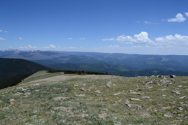
After a little bit, I break out of the trees and any remaining snow to wander up that bald bit of mountain, past mounds of tiny little wildflowers. The gentle, smooth slope makes the next bit rather surprising.


Time to abandon that stock. There are deep cuts in the narrow ridge ahead, so the trail drops down to get below them. Unfortunately, picking out "the" trail from all the use trails is difficult and I don't get down quite far enough. I get caught by the second cleft and have to down climb a little and then scoot down its chute until finding trail. There are a number of false trail looking ledges before I finally get down far enough and then have to climb again. Lake Peak is a little off trail, but there is good trail up to it and I don't want to give this one a miss.


Then down again. The traverse continuing from Lake Peak is much easier to find as there are a lot fewer locals deciding to try some new way this time. There's pretty much just the trail. It follows along to one last seasonal challenge: snow with a big cornice that the trail just plunges into. Where it comes out, nobody knows, at least I don't. I go high and there looks to be trail popping out low, so I go back and go low to follow the trail. It is just well used game trail, so I climb up again. The trail goes somewhere near the peak, so I go for the peak.

There are signs of trail down the slope. There is a suggestion of a flattened line like a bulldozer came through once. Separate from that, there are a few cairns that eventually run into a distinct path. From there, all is easy except when the trail makes a wiggle into the trees going for some snowier areas. Some recent prints start across a big slab of snow, then quit and vanish to the ground. I go further, but it seems absurd to try to follow the trail through this, so turn and also make my own way, gradually cutting back and looking for downward lines without so much snow on them and running into those footprints again before running into some very obvious trail. The snow is almost gone with the drop in elevation, but now there are downed trees to contend with. Lots of downed trees.

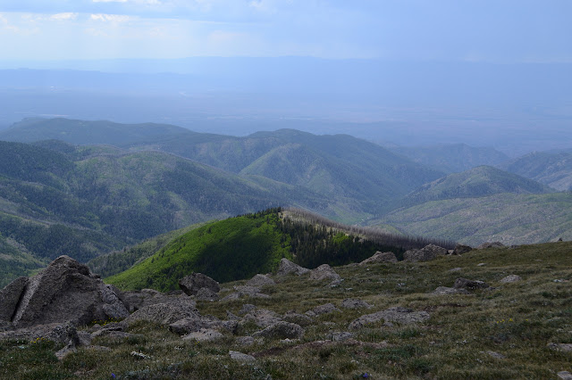
Then down a bit more to meet the Winsor Trail briefly, then away again to climb through forests broken by meadows up onto the edge of Santa Fe Baldy. There was no one on the trail from Lake Peak to Winsor Trail, but after leaving Winsor Trail to climb again on Skyline, there are loads of people, quite a lot of them backpackers. None are stock. This bit of trail also claims to be impassable for stock.


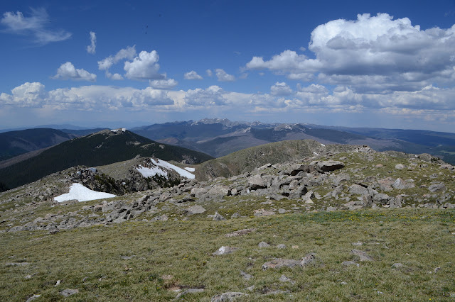
As far as I know, the trail up Santa Fe Baldy is unofficial, but there is an old sign post to mark where it breaks off at the saddle at the top. Wherever the problem is for stock, it seems to be further on.

The trail only braids in one spot, and that not for long. People don't try to vary this one greatly. They get here, they go up. Marmots chirp at me and run off without spinning their tails as they go. Been a while since I've run into a marmot, but the spinning tails on some are cute. Been a while since I was above treeline. I'm really moving slowly today, being often above 12k feet.
Slow steps are enough, though, and I find myself at the top.


And then down again. Retracing steps is easy with well established trail to follow. I don't quite follow it at first because I am looking for the azimuth mark. It's the only marker up here that is actually stamped because the station has been reduced to a drill hole. But then on trail and a little in a hurry, stopping to get some water. I seem to have brought the Sawyer mini, but no dirty water bag. Unfiltered water is a numbers game, the more you drink the more likely you get sick. Humans aren't especially good at guessing when they need to filter, something about being unable to see microscopic critters. I'd rather filter, but I'm not going to go thirsty because I can't. It's got a very fine grit, but it tastes like water. I'll pour out the rest at the end and be done with it. Then again down again, this time on Winsor Trail. It seems like a lot of down past a few backpacker camps and more backpackers coming up.


It sounds like it is raining under the aspens. It has clouded over, but water is not falling. It is tent caterpillars. As if the point needed any clarification, one lands on my shoulder. They have stripped the aspens of leaves so now the only thing the trees are wearing are webs blackened with caterpillar feces. It is the overwhelming smell, too. They are everywhere on the ground, often dead, but stand anywhere for a few seconds and there will be one crawling up your leg.

There are a couple trails down in a long section where Winsor climbs a little. As it gets dark, there is even less to look at. The wilderness boundary comes with a fence for open range and a history lesson on the trail. I would break off to the right to climb Aspen Peak, but not in the dark. It looks like many people head off the other way. That's probably the more usual way to get up to Skyline Trail for a loop like this. The last bit down feels very steep. Benches have been placed, but I am not quite that tired yet. Lots of trails near the bottom cut to the ski resort and parking area, so it is no surprise that I guess wrong and come out off to the side of the information kiosk and bathroom at the trailhead.
A long hike, but oh so good to get above treeline.
New gear:

I got myself some Altra Lone Peaks which got their first round of work on this hike. (I've been pushing my feet into something new and hiking long distances since I was about 12 and I set my record day hike length at 14 miles in some new Hi-tec boots, so I'm not about to change now.) The verdict so far is that they are too wide for my feet. My heel almost slides around in them. Sliding heels is the reason I don't buy men's shoes. I can get them sort of snug around the middle, but when the terrain gets arbitrary my feet start to twist inside the shoe. Then there's the toes. Sure is nice to come back from a long hike without a smashed little toe. The tread doesn't quite feel as grippy to the trail as my Inov-8 Rocklite, but those are some very luggy slippers.
©2019 Valerie Norton
Written 14 Jul 2019
Liked this? Interesting? Click the three bars at the top left for the menu to read more or subscribe!


Comments