Dark Canyon and Runlett Park on Middle Mountain
San Juan National Forest
Click for map.
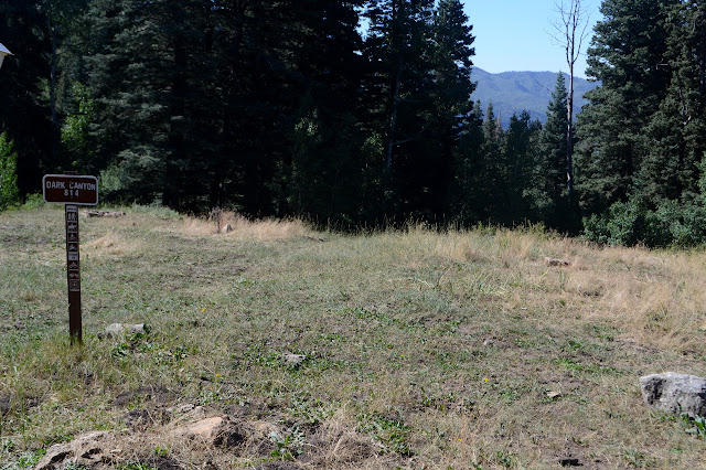
Dark Canyon seems like a good way up Middle Mountain, although with the late start I'm feeling like maybe I should grab the peak in a spur off Cave Basin, which I plan to do later. Anyway, it pops up to Runlett Park which follows the ridge and should be a nice view. Good thing I already knew where I was going. In spite of the prohibition against camping within 100 feet of a trailhead, someone has chosen to park straddling the trail with the sign tucked almost entirely behind their rear to camp in a still shady little hole not far enough off to be legal. There's lots of legal dispersed camping sites just a mile further. The area has a bunch of ATV trails, but this one is a single track limited to motorcycles. Not that I'll quite notice that until it turns into Runlett Park, which allows ATVs, so I'll be a little grumpy about the motorcycles tracks over the next two miles.
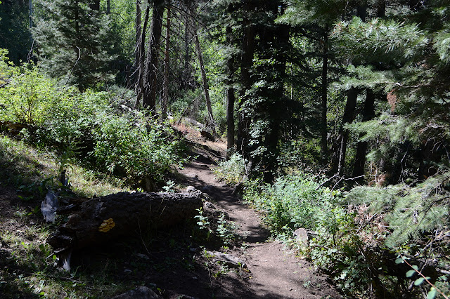

Besides being a bit direct on the downhill, the trail is in good repair. The only tree down is so fresh, I can still see the tracks from the last motorcycle to try the trail passing underneath. It doesn't look like it'll block the next one for long. The views of the reservoir and town are a little surprising for something named Dark Canyon.


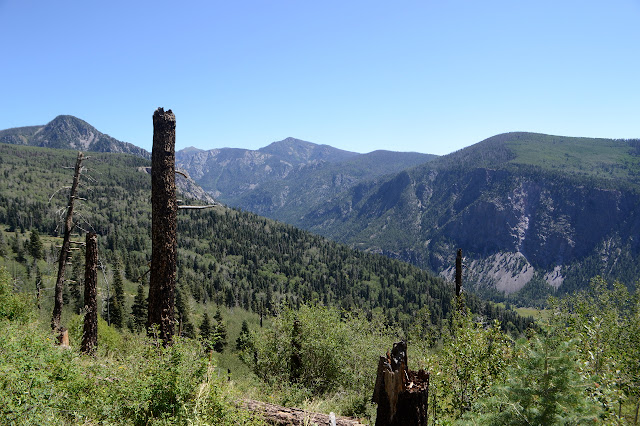
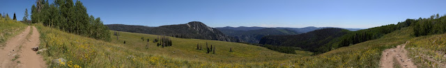
From here, that long ridge line off West Mountain doesn't look like it would be difficult to walk. The densely packed, ever taller on the way down, aspens look like so much field in the distance. It's quite an illusion. Almost convincing even when I know very much better.

Dark Canyon itself is not the least bit dark at this already mid-morning hour. There is a little bit of water running in the seasonal creek and a lot of evidence of cows taking advantage of it. The nearby meadow must make it really attractive to them. No bovine interlopers at the moment.

Then it is time for the climb out of the little canyon. The switchbacks are cut a bit toward the bottom. It is hard to say if it was the cows or the motorcycles that got it started. Further up, it seems like there never were any switchbacks anyway. At the ridge, there's pretty major trail going down as well as up. It is tempting to see where it might go. It looks to be a hiker trail only. Maybe later.

Signs mark the change in the trail a little way up the ridge. What seems to be so much water drainage that nobody goes on is also marked for "no motor vehicles" as if to make it a junction. Some downed trees keep the ATVs from trying to push on further, but I bet the fact that the motorcycle trail clearly won't hold them does a better job of keeping them contained. It's easier to find views along the wider cut old Jeep road the ATVs get to use.


The walk is easy, if a bit looser than the motorcycle trail was. I only have to share it with one ATV. Who apologizes for being noisy. Sort of comes with the territory.

A fence and a ramped cattle guard marks the end of the open range, or just a change in whose cattle leavings I'm smelling. I hope it's the first. It's probably the second.

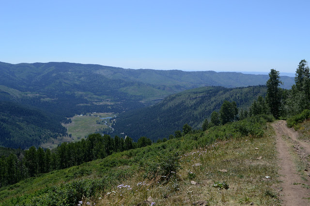
Runlett Park is a vast meadow. The bovine dots far down it would indicate it's just some other cows to smell on this side of the fence.
Finishing off the ATV trail to arrive back at Middle Mountain Road, I find a nice seat below the local weather station to ponder what else I might do now that I'm here. (Answer a, "What's that thing behind you?" question, for one. Inform some motorcycles that there's just one tree down now and they can probably get around it for another.) Further down the road is Tuckerville, or whatever is left of it, and some more mining history. Except for Tuckerville, it looks a little far. USGS maps of the area are way out of date and only partly show the main road, but they can be informative. There's a mysterious sign stating, "private property 5 miles ahead" with "no public access" painted over. USGS shows this ATV trail as a Jeep road that starts down toward Los Pinos River and its ranches at the "junction" between the trails. Perhaps that's what it means. On the other side, there's another old Jeep road that used to go to the top of the mountain. I guess I will go for it today after all. I probably have enough energy in me to follow an old Jeep trail to the top.

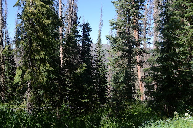
The Jeep road up the mountain, or whatever is left of it, is a little down the road past a building marked on USGS. There is absolutely no sign of that now. There is a little sign of the Jeep road. Not so much that people have been trying it out in their ATVs, but enough that a little way down it I am following a hiking trail. Maybe. Or maybe I'm just following the trail of whoever was up here marking the area forest for timber sale and off limits to firewood cutting. The area is another full of beetle kill. It follows the old Jeep road track on the map.


The out of date maps show Cave Basin Trail starting off from this old road and passing around on the other side of the mountain keeping a different route for most of its length versus the current Forest Service map. I look carefully close and far but can't see anything of that old track now. The road I'm traveling runs into a fence that doesn't even have a ranch gate in it. I do seem to be veering from the track, but sometimes they're a bit off, so I squeeze through the wire. No barbs make it easier. Unfortunately, it just keeps getting more wrong. Old logging roads unmarked on either map give me a chance to veer back toward gaining the peak. With one last cut on a cow path, the old Jeep road is back right where it's supposed to be. Someone has been doing an odd sort of maintenance on it through the trees. Where they have fallen, they have been cut so they lie flat, but not actually removed. It is a lot easier to jump over a tree on the ground than suspended at waist height, but it would be even easier to just walk through. I guess that would just encourage motorcycles.

Since I'm looking at the USGS map, I get to see where the section corners are. One is just a few feet off to road, so I pop over to find the 1938 marker. Near it is another old road that isn't marked. Probably some mine. It's just a little bit further to the top.

The tree covered top doesn't offer much view. There is one little break to the east. I glance around for a register, but the thick undergrowth, falling trees, and generally flat top area make it a bit difficult to decide where to look. Certainly nowhere I glance has it, if there is one.


Following the road back down isn't so hard except that the hike up took more out of me than I expected. I definitely went wrong when I followed new tracks across the fence instead of keeping to the top of the meadow it was following. Meadows do have a way of eating old roads and trails up. And what is that fence for if I can go around it without going anywhere a cow can't go? I find new places to go wrong below that, but trusting the track on the map and the track I made on my GPS coming up helps get me back in line.

Back to the road, I am back on easy street. The ATV trail has now had so many people on it that I am surprised to see a few of my own footprints still on it. I certainly don't notice any bear prints again. I do see grouse prints, but I cheated and saw the grouse too. One last ATV passes and I take a slight detour to try to find a second section corner. It is no good in the thick trees full of beetle kill, many fallen, and the undergrowth getting thick below. I think I got to the right place, but find no proof. Onward, I look a little more closely at the "junction". Maybe it isn't just a drainage area marked "no motor vehicles". Maybe it is a bit of old road with no public access at the bottom. It looks like no one tries it, not even hikers. It is too late to try where the hikers do go. The motorcycles were here, but decided to quit, take a look on foot a short way, then go back as the trail takes a short but disturbingly vertical stretch. One of them really wasn't properly attired for possible falls.

It's just been me and the cows in Dark Canyon all day. I'm out of water as I get to the single stream crossing. I have the Sawyer Mini and a dirty water bag this time, so I can fix that... maybe. No water comes through the usually too slow filter and when a drop does make it, it tastes of algae. You have to put a little bleach through it if it's going to sit a while. Apparently I didn't. I'll just have to go thirsty for another mile. It feels long. The one tree is still there, but so broken up those two would have just pushed the part across the trail off it had they not turned back at the slopes. I give it a kick as I go over and one side almost comes loose. Then a short up to the now clear trailhead and water in the car.
©2019 Valerie Norton
Written 16 Sep 2019
Liked this? Interesting? Click the three bars at the top left for the menu to read more or subscribe!


Comments