Vallecito to Windom: Windom Peak
San Juan National Forest
DAY 1 | DAY 2 | DAY 3 | DAY 4 | DAY 5
Click for map.
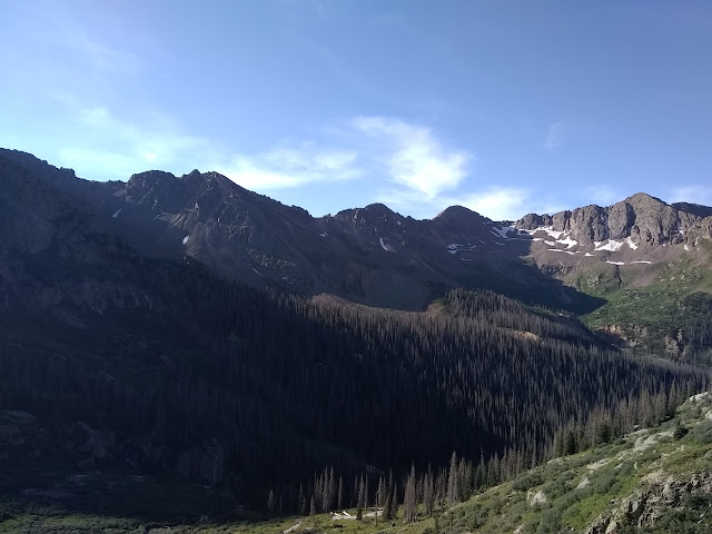
It looks like a stunning day for a mountain climb, but little wisps of cloud form quickly. Decorative or previews of what is to come? I could certainly have started earlier, but suspect this is early enough as I make my way to the trail and up, past the sign banning camping beyond. The mountain goats are on their daily commute down. They are a bigger group, 6 or 8, but still keep the wary but not scared attitude. Do they figure it out when the hunters come or are they just lucky that goat tags are hard to come by?


As I looked across from Columbine Pass yesterday, I could see this trail cut into the slopes up to Twin Lakes and wondered at the traffic that could have made such a use trail. Also about the way it seemed to flirt with one steep cascade, getting into the water and leaving again, then cross another. Now that I am on it, I see built up steps and sides of what could be Depression era CCC work or similar. Again, there are mines above that were undoubtedly worked by mule, so it could come from that, too. The trail stays to the dry as it swings to the edge of one cascade, then crosses as a rather safe spot at the other.
At the first lake, a use trail, a thin and very distinct dirt track at first, crosses the outflow and makes its way to Mount Eolus. A fellow taking in the lake says he seems to be done climbing these peaks but is waiting for his son to come down. He seems a bit young to claim it is all over for him already. More trail goes around the lake to the right, crossing ice fields and dropping onto some more built trail.


There are people already coming down. The second set includes one who found the last bit up Windom to have a bit of exposure. He even had help pointing out where to put his feet going up. Somehow down was less hard. I ponder this, but until I see it I don't know what to think. As usual, I'll just deal with what's in front of me. The second pair has helmets and have already picked off Windom and Sunlight and are now off to Eolus. The built trail trail seems to end at a giant, stupa level, cairn. A second one sits across the way. Use trails with cairns extend around to the right and across to the other huge cairn. Maybe the lower one goes to Sunlight Peak? They probably can split higher, so maybe not. I expect they are just choices for the same thing. Since across drops a few feet, of course I select the trail to the right with a bit more icy snow to trample through. I'm sure there's others that look at that snow and of course go across to skip it.

There are more and more trail choices as I go, but they do take me up to the saddle I was looking at. The first step up from the saddle is a little bit scrambly, but then it is back to walking with a touch of boulder hopping. There's more coming down. A double, a single, a triple, another double. One set has made this their first 14er coming from near the Adirondacks where the mountains are about a third as tall.


I find myself tending off to the left as I climb the west ridge, but there are lots of well used trails. This one does hit some snow with a mild climb around it. Eventually, everything narrows down. I find myself almost at the top with just a dirt gully between me and the summit block. I'm careful on the trail down and up again, the rest of the gully below the top is quite steep and it looks like a slip could go for a while.


I don't feel especially exposed as I climb the summit block, but I can see where some might. There is a bit of a drop out there. As I try to take in the whole of the view, I have to move around it a bit because I never quite climb to the very top, just touch it. Some directions make me feel a rather strong need to hold on.


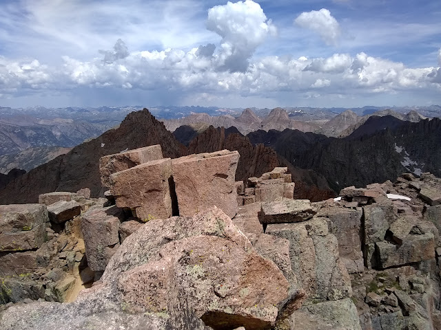
Trying out the panorama function instead of collecting some to piece together with a program later just makes it clear there needs to be a new rule. Do not use the panorama function. It can sort of be used to sort out where the other photos go in the circle.


With the weather threatening, it is all too soon time to get moving downward again. I follow pretty near the same track down even though I am not trying so much to do so. It just happens to be the one I know, now. At least a little bit. There are a few rain drops before the saddle, but it is not bad. There are some rumbles before the lakes, but distant. The set that were coming down off Sunlight and Windom as I went out are just getting to the lake coming off Eolus. They must have started really early, but managed the whole set in a day. Their verdict on the routes up the other two is class 4, way out of my league. It's not a bad place to revisit if I decide differently down the road. It's good trail the rest of the way with just enough rain to keep everyone reminded that we could get wet if we don't get moving.

And then I'm back at my tent, all set up, with rain coming down not too hard and some rumbling. It's an easy thing to hop into the shelter, harder to take it down wet and pack up for another 6 miles or so. Maybe the rain will quit. I hop in, and the rain gets harder. Distant rumbles and off and on rain make it not so attractive to pack up and get moving to a high pass and an equally high trail to another high pass and some high mesa travel. And I'm starting to question my way back, which isn't going to get started today.
ON TO THE NEXT DAY ⇒
©2019 Valerie Norton
Written 8 Sep 2019
Liked this? Interesting? Click the three bars at the top left for the menu to read more or subscribe!


Comments