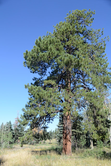
Animas Overlook on Barnes Mountain
San Juan National Forest
Click for map.
Well, I managed to put a hole in my "new" Altras. I noticed a thin spot in the side as I put them on for Dark Canyon and I noticed I could stick my finger through as I put them on for Cave Basin, so now I have a glob of Shoe Goo filling it in. It's a weird spot, on the inside of the shoe right by the ball of my foot. I must have scraped it across the trees as I "hopped" over them through the major burn down West Mountain. They barely have 300 miles on them. That's only like 3 weeks to the through hikers that these are supposed to be popular with. Then again, they do tend to hike cleaner trails. So now I want to see if this Shoe Goo will hold. I've usually used E-6000 to fill in the holes that eventually develop, but I seem to have got a collection of adhesives and the Shoe Goo is a little harder and should be more tuned to the job. So I'll test out some trails that OpenStreetMap shows in the area, stop by the short interpretive loop at the Animas Overlook, then back to camp.

The road is crossed by one of the many trails on the map as I make my way up. What is actually there is a bulldozer path on one side and a thin trail on the other. I had this particular trail mapped out to loop with a section of Colorado Trail, but the loop comes out to 32 miles and I'm not quite ready to day hike that. Still, ~20 on the CT and ~10 to connect the loop? I could try for a quick overnight. I'm really looking for a second trail a little further near where a benchmark called "horn" should be. Okay, I just want to get the benchmark, but the various testing needs done too. That trail is more bulldozer line. The benchmark is supposed to be a little above it but not at the top of Barnes Mountain. I look where it is marked and where it seems more reasonable to be placed and all I can find is a well used camp site. No benchmark for me. The bulldozer line continues on as marked, then turns down to connect with the first one I saw. A much older bulldozer line continues along the top where I want to go with very little trail to be seen. Little tanks were dug along the path, so there is a string of dry pools to confirm I'm still following it as what trail there is rapidly vanishes.

There is definitely no complete trail to follow although there is often some kind of trail. I move to where the map indicates trail and often find something, but it never goes more than a quarter mile and ends somewhere "off trail" and never more than a game trail anyway. There are signs a bulldozer passed once, but the little tanks are only along the flatter top. When the marked trail swings off to the right of the ridge, then follows a fence line back up to the ridge, I'm pretty sure that whoever contributed this line to the map was squinting at areal photographs guessing where there might be a trail.

The way gets brushier as I get lower. Little oaks are growing up where fire has burned instead of the aspens a little higher up. Cows have kept paths open through it all, so the way is never particularly hard. Just lacking in the indicated trail on the map. I almost trip over a section corner, so I do get a benchmark, just not the one I was expecting.


I'm still a little way from the overlook when I pop out on the road. I've just run out of desire to thrash, even through short stuff. The Shoe Goo seems to be holding, though.

The sign beside the paved parking lot says the paved, wheelchair accessible trail has a 5% grade over its 2/3 mile length with a map showing the placement of signs, benches, picnic tables, and bathrooms. It applies the adjective "gentle" to the grade, but I'm not so sure that is, especially since it has a tendency to be a sustained grade for big chunks. Oh, and the bathroom is locked.
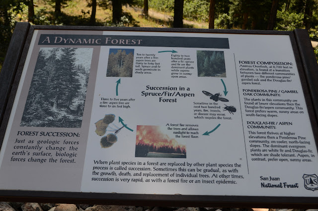
The signs start off big, talking about the watershed. San Juan National Forest was created partly to protect the watershed. The next goes on about forest succession where fire opens the space for aspens to grow, aspens shade the area for spruce and fir, spruce and fir succumb to bugs and disease, and in comes the fire again. The picture is a rather gruesome, encompassing fire. Off on the side, it points out this is the community above this elevation. The community below is made up of ponderosa pine and gambel oak. So that explains the different communities I found walking down the ridge line.

For local color, quotes from an old guide book as it concerned the Animas Valley and then a little of the local Basketmaker People who grew some of the earliest corn in North America. A few more before the trail takes a long climb upward with only slight thoughts of resting spots for the wheeled visitors it purports to support.


I have a bit over a mile heading up the road to get back to my start. That's a little past where they start to allow camping along here.


©2019 Valerie Norton
Written 19 Sep 2019
Liked this? Interesting? Click the three bars at the top left for the menu to read more or subscribe!


Comments