Posey's Trail
Bears Ears National Monument
Click for map.
There is a large display about Posey in the visitor center in Blanding and he supposedly escaped along this path during one of the generally unmentioned Indian wars, this one in 1923 being the "last". He led "bands" against ranchers in the area and seems to have a bit of a mythos built around him now. Anyway, he's an important enough character in the area history and you can walk in his footsteps as he made his way across the forbidding barrier of Comb Ridge while escaping a posse. If you can find it. The free guide, 101 Ways to Experience San Juan County, Utah, may have pointed me in the wrong direction for this, its suggestion #32, but a geocacher has my back in finding one end of Posey's Trail. The geocache was set right at the top as the trail starts down from the ridge to Comb Wash and included coordinates for the east end in the written description. It's been there since 2002 and it looks as if the only thing that has had any attention since then is the gravel turnout. It curves its way around a speed limit sign, which is the only thing even resembling a sign in the area. There is almost no trail visible through the brush to the wooden ladder that goes over the barbed wire fence. I guess it's a sign in a more abstract sense.

I climb up the ladder to find the far side has broken. The lower rung and the lower half of one side have vanished leaving the second rung hanging. With extreme care, it is usable. The far side of the fence is nowhere near as brushy and the trail actually looks fairly distinct for something that often hits a bit of sandstone. Cairns have been stacked to help out when it gets a little lighter or little water courses make it confusing. They are often nice hints and necessary when it hits larger bits of sandstone. There are no footprints. And it actually has a bit of view.


Unfortunately, the cairns split and then there is double the fun for finding the trail. What goes right looks more used to me, but I quickly find I have chosen incorrectly. After quite a few, there are suddenly no more cairns to be found and only animal trails to follow. I can still see the other row to my left as they drop down into a dip and up the other side. I backtrack and try again, but without enough confidence to break down the decoy cairns. Left continues steadily.


Steadily is not to say without confusion. The cairns start up a stream bed, which seems suspicious. They are bulkier and taller, they mean business, so I follow them anyway. Across a flat that must stay muddy longer, there are finally footprints frozen in the hardened dirt. Somewhere near here is the end of that road I was following and which has nothing to do with Posey's Trail as it turns out. I get to the edge with a few minutes to the sunset.


Looking at that trail hugging into the side of the cliff, I really want to follow it down. It's just that when I finish, it will be dark and I have to find my way back to the car. I don't much like the idea of taking the highway or of trying to follow this trail in the dark. Hey, I could just walk over to camp, which is a short way down that dirt road to the south. (The campground is free and has toilets and some tables, but it takes two hours for the sun to get over the ridge and the air only warms a couple degrees, if that, before direct sunlight hits.) The trouble with that is all my food is in the car. I still can't quite be sure where the western side of the trail is. I think I can see trail going out to near the intersection with UT-95 and the county road going north. Maybe. I could come back for it but I know I'll get distracted by other things that feel newer.


I head a little way down the trail before turning back. The trail seems solid enough and "there" enough. Still, it is actually the other part of the trail in the dark I worry about, so I get back on it while there is still light. I seem to follow the ridge a little more instead of getting into the former mud puddle, so have to work my way over carefully to where I know the trail is. From there, the trail actually seems easier to follow in the low light. I've actually noticed trails across rocks be easier in low light before, so that's not so astonishing. My astonishing prize for turning back instead of going on is the way the cliffs to the south seem to suck up and multiply the little bit of red light that still bends around the planet to hit them.
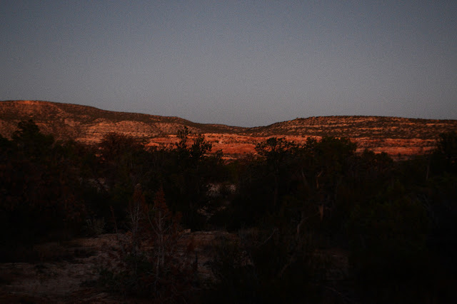
The cliffs seem to glow all the way as I walk back, even as I'm almost to the broken ladder once again and thinking I might really want a flashlight.
©2019 Valerie Norton
Written 2 Nov 2019
Liked this? Interesting? Click the three bars at the top left for the menu to read more or subscribe!


Comments