Posts

sketches

Image
The last sketches of the year. I have nearly finished off this book. Comparing the lush green north facing slope to the burned and sparse south facing slope while heading down Snyder Trail. I found a spot where the power lines still hang (sort of) on the way down Tunnel after climbing Cathedral. Before climbing back up a random fuel break , took a moment to take in the ocean. Before finishing the climb up Fremont Ridge, I took in the low lake and high bridge .

USS Midway

Image
San Diego Sung has been wanting to actually tour the aircraft carrier turned museum down in San Diego and I said sure, so off we go. Of course we start off just attempting to take in the size of the boat. There is something downright comical about the snack bar and tables at the stern and manikin service men eternally hang about on deck. It gets serious quickly going forward. The length of the USS Midway with snack bar at the back.

Scotty's Castle

Image
Death Valley National Park Locate the place. After an unforced error resulted in a an unplanned night on Hunter Mountain and some extreme good luck fixed the problem before lunch, we stopped by Scotty's Castle to find a gas station. Unless the 1920s era tanks are still legal, there is no sign of such a thing anywhere and strong signs the old AAA map is wrong. Still, we are here and it is a very silly place so we cannot exactly leave it again without having a look around. The place seems designed to evoke the idea of a castle very strongly without in any way being anything like a castle. The main house and some of the auxiliary buildings at Scotty's Castle.

Ubehebe Peak

Image
Death Valley National Park Locate the trailhead. We could see the trail to Ubehebe Peak switchbacking toward a northern saddle on our way back from wandering around the Grandstand. The trail is unmarked and starts from the same parking lot. A little examination and its worn surface pops out. The rock lined edges help pick it out. We found the start before leaving in the evening so we were sure of where to return to for a morning hike. Now we just start up it and see how it turns out. Ubehebe Peak (on the far left). The switchbacks can just be seen as a light colored zig-zag to the saddle near the right. The "island" of the Grandstand rises from the solid and dry mud of the Racetrack.

Racetrack Valley

Image
Death Valley National Park Locate the trailhead. The road into Racetrack from the north is best with high clearance although some were carefully making their way in passenger cars. We got to the parking by the Grandstand with the shadows getting long and walked out onto the dry mud of the playa (dry lake bed). The footprints of those who came when it was wet and ignored the sign warning against walking on it then are few, but well preserved. There are also tire tracks, both from when it was wet and dry, from those who really want to mess things up. The land is designated wilderness away from the road and the park does not allow off road travel. All these marks were fewer as we got further out. A single island in the middle of the lake bed is called the Grandstand.

junctions

Image
Death Valley National Park On the way to Ubehebe Crater, traveling the otherwise sign free roads, we came upon a crankshaft sitting upright at a junction. Assuming some of it is buried to keep it upright, a straight eight crankshaft. Off in the bushes, a pair from a V8 have also been contributed to mark the junction. We had obviously come to Crankshaft Junction. We have arrived at Crankshaft Junction.  Photo by Sung Byun. On the way from Ubehebe Crater to the Racetrack, we pass Teakettle Junction. Would we also find a tea kettle? We arrive at Teakettle Junction. Why, yes, we would. Quite a few tea kettles, in fact. The original that marked this junction is long gone, but many have been contributed to take its place. These are all dated and have messages. Only one is from 2013, the rest are 2014 and at least one comes from the other side of the planet. ©2015 Valerie Norton Posted 8 January 2015

Ubehebe Crater

Image
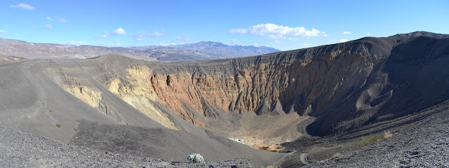
Death Valley National Park Locate the place. Our next stop is the Racetrack, but we cannot go past Ubehebe Crater without at least looking at it. It is a large hole in the ground and has similar, although smaller, neighbors, and it is quite the oddity. I look across at layers while a sign assures me it is volcanic in origin. Granite may flake away in layers, but I cannot pick out the edges of them if they are not flaking. I also look across and stand upon a dark layer that seems to have settled upon everything like grey icing. The layer seems to be cinders. The sign explains further about the volcanic action, how water sank down and met magma producing superheated steam that gathered until a weakness blew out this pressure cooker with no safety valve. Ubehebe Crater. One trail leads along the edge to the right and to other nearby craters and another leads along the edge to the left and down into the bottom. A circuit may also be made. We have a schedule to keep with ...

Eureka Dunes

Image
Death Valley National Park Locate the trailhead. Sung gave me a last minute chance to return to Death Valley and jumped at it. This did mean giving up another trip to Joshua Tree, but the logistics of finding a hike while others are focused on climbing rocks is not as simple as finding a hike with someone focused on poking around and hiking. The first stopping point is Eureka Dunes. We approached them in the late afternoon along the best road in, a wide strip of washboard dirt road the average passenger car would be capable of traveling. The dunes are at the far end of the valley on this approach, a sudden large pile at the end of a vast flat like some giant has just emptied his shoes after the beach. The mountains behind them make them seem small although they are some of the tallest, rising nearly 700 feet above the dry lake bed. They got more impressive as we got closer. A huge pile of sand rises in the distance. We settled into the camp, a place with a few concr...