(South Fork Eel) River Trail
Humboldt Redwoods State Park
Click for map in new tab.
For a second day among the redwoods, I proposed to wander the gentle loop of Rockefeller Grove and cross Bull Creek in my ripped up old shoes, then put on my good shoes and socks to hike beside the Eel River for as far as I got. (Perhaps I should refer to it throughout as the Wiya't River in a private little campaign against banal river names foist upon already well known bodies of water.) I figured this would be an excellent way to take in the autumnal season. Okay, I was worried it might stay too far up above the side of the river to really see those colorful trees at the edge, but it would be a good hike and I'd probably have it to myself without the bridges put away.

I was surprised to find no notes at the kiosk warning that the bridges were gone for the season and held out a little hope that they might still be out for my use.

I turned onto the unsigned River Trail that starts off crossing Bull Creek next to the Eel River. A second crossing further up is signed. Bridge pieces were stacked up just inside the trees and there was no bridge. There was, however, the gooiest slick mud on the banks and I kept myself very balanced as I crossed it, sinking in an inch with each step. Crossing the foot of water in the creek was much less notable. No one else had crossed through the creek, but there was a single set of footprints from the nearest log to the trail climbing up the other side. They had to battle just as much mud as I did, but with dry feet.


I got up the other side of the creek having remained vertical. The surface of the trail quickly became a more solid feeling dirt as I got higher. As I could pay more attention to the surroundings, I found myself among another rather grand stand of big trees on a large flat. It took a while to get to the signed junction and I still hadn't found a seat to put on my good shoes.


I found some log rounds (just past an unnoticed bench) that made a nice seat for changing my shoes. Had I thought about it a little more, I'd have brought a bag to stuff the wet and muddy shoes into. I scraped off the mud, which had just oozed upward rather than off while walking the forest trail, and stuffed them down into the debris scoop for the last crossing. The mud would dry and become indistinguishable from the rest of the gathered dirt in there. I was ready to do some miles.

Decker Creek is the first, and possibly most beautiful creek. John Scott Douglas already has it claimed for a memorial grove.


On the other side of the creek, I found an access trail for the Wakefield Baker Grove. Seeing many hints of yellow at the edge of the river, I decided to see how much it accesses. People have been missing the switchbacks on their way down, then catching something that is probably an older route for the River Trail to head back. It scampered across a gully and found a way to a small piece of even older road and stopped by the side of the river, but not a part of it I was aiming at.


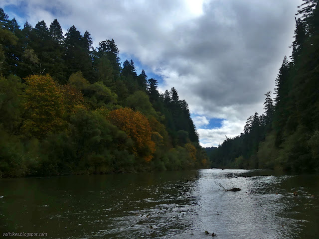
I walked back to where the trail had turned back to the north and looked around at more than just the impressive trees. Across a wide patch of redwood sorrel was a bench cut into the side of a huge fallen log. The sorrel showed few people have taken advantage of this bench recently. I went to it and found more trail apparent across the top of the log and followed that down to a trail to the edge of the river. More slick mud was on this trail and I failed to stay upright, but I did get a good spot to take in the river in autumn. With the back of my trousers caked in mud.

The best thing to do for mud encrusted trousers is to ignore it and it'll go away, so that's what I did. I turned around and had to search around for the spot I'd come down, but eventually found it and got up it without further incident. Worth it? Not sure, but I wasn't going to work that hard to get down to the side of the river again. I retraced my steps back along the log and down the seat and then looked over the old trail as it extended south under some fallen trees, then returned to the current route.

The rivers were the highways that most easily took these giant trees off to become grape stakes and other things of more and less consequence. It is amazing to see so many beside the river. There were more. Flooding in 1954-1955 washed away 50 acres and 525 trees from the Rockefeller Forest with the severity attributed to the upstream logging practices. I was pondering the wonders of so many trees left when I was reminded that not all are left. I had come upon some stumps. There were still big trees around, the area had not been clearcut, but all too many had vanished from their rightful place towering over everything but the other redwoods. The stumps got worse as I went.


I came to Mill Creek. (Speaking of banal names, there must be Mill Creek every 20 miles at least.) The creek itself was pretty, but around it I was noticing erosion patterns that I hadn't seen at the start. I crossed one steep old road that had become a thin, deep wash below the trail. Other washes, big and little, were frequent.


I spotted a bit of old trail that was heading for the cliff above the river and tried it out for a view point. Surprisingly, it continued on as a ledge, dropping along the side of the cliff. It was still over a foot wide, but I somehow wasn't ready to try it.

Back on the current trail, it came to an even clearer bit of trail toward the river, this one with less view, just before a bridge. Across the bridge, the trail was filled with mushrooms and there was an old stump that had been roofed over to use as a storage shed.


A nice big sign heralded my arrival at the trail access at Burlington. I headed down, this time helped to stay upright by some cable steps showing a little wear at the bottom and accompanied only by bear prints in the sloppy mud. The bridge was gone and the plants on the currently dry gravel showed new debris caught up about neck height. It was probably pushed down a bit when gathering these shredded bits of vegetative flotsome, but it still marks a river too high to leave a seasonal bridge. I saw no sign of it, but it was probably stacked up on the far side.
From the mileages on the sign and the time, it looked like Canoe Creek would make a good turn around point.


Another piece of abandoned trail closer to the river presented itself and I took it to a lookout point. From there, I pushed on along the old tread, over a couple of downed trees as it got quite thin but never threatened to drop off the side. I passed a few abandoned grove signs along the way. Of course, that means old growth again.


The trail split, with an even longer abandoned section dropping down closer to the river edge. Some of the travel along the last bit was tough enough that I went up to catch the current trail. It took a couple switchbacks, but the only trees down in the section were a few inches wide. That part of the trail was very clear, but it was still obvious at the top which way the current trail goes. I passed the signed junction for Grasshopper Camp on the way to a flat and then the edge of a bowl of trees.


I passed another junction for Grasshopper Camp and continued to bend away from the river toward the Canoe Creek crossing. Pondering the trees below me and how there didn't seem to be so many redwoods above (which is part of a recent burn), I came to a wide and shallow creek with the pieces of a seasonal bridge stacked up on the far side.

Sure, I had shoes to put on to cross that little creek easily, but it was about time to turn back, as expected. I snacked a bit in this one spot where no traffic noise ever penetrated from the freeway and scenic alternate on the other side of the river before turning back.

I headed up the trail to Grasshopper Camp for a slight change in route. I was just going to go to where it met the other signed trail. That turned out to be at a quarter mile of solid climbing in a high flat with a few redwoods and a giant sign. This sign said I had missed out on the Canoe Creek Loop back the way I came. The park brochure is no help in figuring out what this is, but the USGS map shows the loop being the inward curve of the trail as it is now joined the short way with another trail that comes off the end of the Grasshopper Camp Trail I'd just come up. I saw that trail, with a stick in front of it suggesting it was preferred I not go there, suspecting it was old road heading to a ford across the river. Perhaps I'll have to try the loop another time.

I headed back down the other trail, which is somewhat longer in taking the descent. Then it was back to checking out redwoods and the hints of the season just the other side of those beside the river.

Back among the particularly big trees near Rockefeller grove at the junction, I kept left to get to the other crossing. The trail climbs high up into smaller trees and looks steeply down onto rougher water in Bull Creek.

I got to a second junction and switchbacks down to the creek level, first through another of those nice flood plain stands of redwoods. The trail split and the greater part of it went where signs indicated it should not. I had to explore and found myself at the top of an elaborate array of a few trunks that create a bridge over the creek that keeps one well away from the banks.

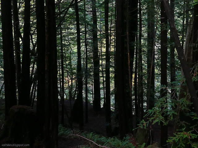
I did not try the natural bridge, with its rolled top that looked smoothed by the passage of feet. I went down the trail, down to the pebbled banks and changed my shoes before plunging on through. No squishy or slick mud here! I headed up and found a similar extra trail connecting to the top of the logs. Signed junctions mark the trail I came up as "Burlington" and show where to turn for the Bull Creek Trail North and what is the Rockefeller Loop. I followed the other side of it back to the parking lot through an increasingly dark forest. With the clouds, land, and trees, most of twilight happened before sunset.

It was very nearly dark as I finished all of five minutes after sunset. It's the season where I'll have to make an effort not to waste morning hours of light with driving. There weren't the grand vistas of autumn I was hoping for, but seasonal color was a constant, if faint, companion.
*photo album*
©2021 Valerie Norton
Written 16 Nov 2021
Liked this? Interesting? Click the three bars at the top left for the menu to read more or subscribe!


Comments