Dolason Prairie and Tall Trees
Redwood National Park

In the once upon a time, after backpacking around Redwood Creek, I stopped by Lyons Ranch and Dolason Hill Prairie. Then I only hiked down the trail as far as the historic barn, about a mile. I decided it was time to take on the whole trail. With temperatures climbing a bit inland and it being wise to consider this a mostly inland trail, it would be a warm day for it. The current conditions page lists the trail as only "partly open" due to downed trees. On the one hand, this page still lists the central portion of Rhododendron Trail as closed for the collapsed bridge that was cleared away and trail smoothed to make the small creek crossing easier years ago. It makes the bold statement that the seasonal bridges in Fern Canyon are both in place and removed. On the other hand, this is a National Park page and they might be better about the conditions of trails that are actually in the National Park, like Dolason Prairie Trail. (On the other other hand, it doesn't even list Lady Bird Johnson Trail or Berry Glen Trail, both on the National Park.) I delayed. This is trail damage from 2023. I checked the Strava heat map, which only shows tracks from the last year. It showed probably two tracks out and back traveling the whole way. I made backup plans and went for it.

Of three cars traveling along Bald Hills, they all pulled into the trailhead. First in was a trail crew and second were a pair of hikers heading for the barn. This is the most common hike done from here, after all. The trail crew confirmed there was "old growth" down a little short of halfway and I might get past that. The bridge is out over Emerald Creek, almost to the end, and I won't get past that. None of that was their target. They were mostly out to mow the prairie beside the trail. Priorities. (I failed to ask him if he'd ever seen the lower section of the 44 Creek Loop. Major opportunity missed.)

The information sign is followed by a sign with mileages. It's 5 miles to the intersection with Emerald Ridge Trail from the top. They've added a printed metal sign about the bridge closure to the left post. They mean it, and they'll mean it for a while. The trail splits, the right side is those seeking the view and the left drops down among trees to a road below. It jogs to the right for longer than seems natural, but there's a sign to say where to leave the road and drop among more trees.


I didn't poke around the barn on this trip. Instead, it was across the prairie to the trees on the far side. The trail winds down further at the edge of those trees, then for another long switchback in the lower prairie section before finally getting properly into the trees again.


Once really into the forest, it was clear this is an old growth stand. There's small groups of truly massive trees just standing around.

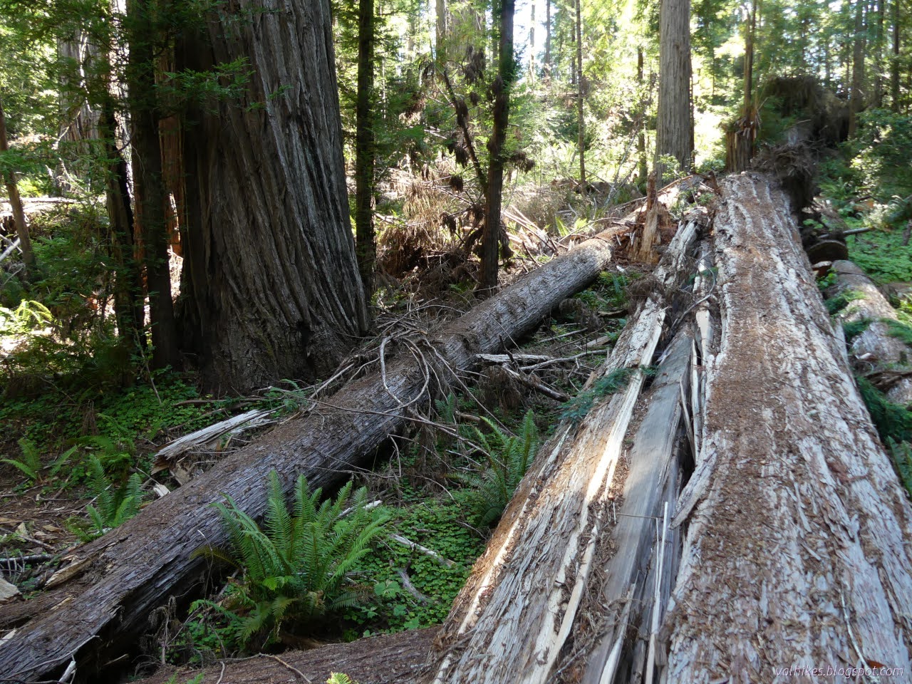
The downed old growth comes soon in this stand. I had taken the trail worker's meaning to be that there was a tree lying across the trail that even in repose was taller than I am, and I wasn't disappointed.

I looked at the trails to see what I thought. It's actually set up to go right over the top. The cut tree in front has a half round set on top. From there, it is a stretch, but possible, to get up onto the bark ridges. Those form some large steps all the way to the top. Since the tree hits the trail at a sharp angle, there's some 40 feet of trail under it. Walk along it and there's another iffy, but usable arrangement to get back down. There's a second large tree down shortly after, set up with more aids that, again, best advice would be against using. So the closure at the 2 mile mark is advisory.

So with that good advice not taken, I continued along. Happily the smaller trees have been removed from the trail after this difficult spot. There were a few more down and the trail tends to stay in this old forest for the rest of the route.


There was still one tree down on the trail, but the branches it knocked off as it came down are still green. It was probably quite recent and they've surely not had a chance to get at it. Past it, the trail continues to wind downward.

I heard water flowing and I came to the bridge. Besides the small tree still hanging among the smashed railing, the signs to mention "this is the closed bridge", the lattice work of screwed in fence to say "really, don't go here", the twigs threaded in to say "and don't climb over the fence either", there's a rather large crack in the base structure. One of the major cross beams has split for several feet.


So I could deal with not crossing the bridge, but I did say I'll see where the trails go. I'd spotted a trail down on the way to the bridge. I went back to see where it went. It at least suggested potential. And did I want to try it? The only reason to cross the creek is if I want to do the loop through Tall Trees. That's signed as 4 miles, but you have to go through the Tall Trees loop to see the best trees. That's more like 5 miles for the loop. I'd only done the easiest 5 miles, the downhill, so was feeling quite happy about trying.


The first half of the trail down was reasonable, but it took a good bit of looking before finding the route for the second half that I was sure I could get back up again, especially since I would grab water for the big climb on the way. The crossing was easy enough in this season. Up again was particularly steep on the way to join an animal trail that joined the trail on the other side.

Since I'd already gone on the loop clockwise, I turned right for the counter-clockwise view. Up to the parking lot, then down the main trail through big trees to the particularly tall giants waiting below. The bridge closure is signed on this side, too, but more signs point out the closure of a trailless area on the far side of Redwood Creek. Too many people are stomping through the woods to try to see (the current) Hyperion. It's the tallest one that they've measured, until something happens to it. There's a lot of trees they haven't measured. A few of them are even in spots suitable to producing particularly tall trees. If you do go to its base, stomp around on its roots, you can't see anything of how much taller it is than its neighbors. That's lost in the canopy that also serves to make a GPS highly inaccurate, so you won't know if you really got there. Hyperion was definitely not on my agenda.


The low point of the trail seems particularly well traveled, but the loop through the Tall Trees Grove is much narrower. It's only a little extra (signed as 1 mile) to take the loop, so I did. Still feeling good! Plus, the best trees are just a little removed from the greatest travel. I like the upper portion of the loop best, but the lower side also has excellent features.


The even smaller bit of Redwood Creek Trail heads off north at a signed junction. Shortly after it, there are no redwoods on the creek side of the trail. There's mostly long maples growing sideways.


The last leg of the larger loop is only available when the water is low, generally in summer and into fall. It consists not of trail, but make-your-own-way travel along the gravel bars and through the creek. (It is strongly recommended not to drink the water in the creek since it is highly subject to cyanobacteria (blue-green algae) blooms.) Much of the year, one must simply go back the same way.


I was expecting knee high water, but got into some nearly waist deep while not paying sufficient attention to the lay of the land under the water. It can be quite hard to see that.


Since the gravel doesn't hold much of a trail and the river cleans away any from the previous year, it can be hard to spot the trail up and away from Redwood Creek. Where the dirt starts, it does support a trail. There's a bright orange sign on the right of the trail, but it is half eaten by the tree it was nailed to and thin branches hang over it, depending on angle. The brown junction sign on the left might be the easier one to spot.


So I headed up and turned for the creek and felt no desire to try to challenge the bridge closure since I needed water anyway. Getting back up was harder than expected. While I can recommend heading past the downed trees, if you are comfortable with it, and coming to see Emerald Creek, I absolutely cannot recommend actually crossing Emerald Creek. It would be quite nice if there was a good way down it, though.

Back on trail, I started up the hardest 5 miles of the day. The sloshing upstream through Redwood Creek had started to hint that I was getting tired. There were still 2000 feet to climb to get to the car. With that big tree to clamber over after the first 1000 feet.


I was definitely not moving upward as quickly as I hoped. I wouldn't be seeing sunset from the Redwood Overlook on down the road, a spot where one might get a more meaningful look at Hyperion.


As expected, I found that although the lower section of trail through prairie was not mowed, the entire section past the barn was. The trail crew was long gone. I did manage to arrive at likely the only spot sunset is viewable on the trail in a timely manner.


The last little bits of forest were already plunged into darkness as I made my way up the trail. It was still easy to follow without a light. I wasn't too keen on the actual hiking feel of those last couple miles. That's the danger of the "upside down" hike starting with the downhill.
*photo album with 86 photos*
©2024 Valerie Norton
Written 4 Sep 2024
Liked this? Interesting? Click the three bars at the top left for the menu to read more or subscribe!


Comments