Lost Coast: Rattlesnake Ridge
King Range National Conservation Area, Arcata BLM
(green line, map link)
DAY 1 | DAY 2 | DAY 3 | DAY 4 | DAY 5 | DAY 6 | DAY 7
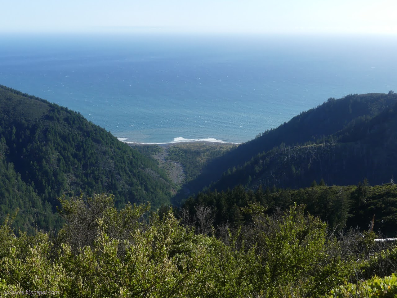
No rain, but my tarp was soggy with dew for the morning. A big fat moon sat above the ocean and I realized that except for a brief blurry light in the sky the morning before, I'd seen no sign of the moon at all so far. I breakfasted and packed not intending to head up Horse Mountain Creek Trail after all. I also didn't really care to go up Buck Creek Trail. I figured I'd camp at Randall Creek. I just needed to be reasonably early traveling the impassible zone on the way back to Miller Flat. A delightful tease of sunlight played on a piece of the waves, let in by the window of the canyon of Horse Mountain Creek. Otherwise, I was consumed by the shadow of the cliffs.


The sun got up over the hills and everything became even grander out along the ocean rocks.


The boulders below Miller Flat became my walking surface and I was quickly tired of them. They weren't even wet and slippery. I headed up the flat as soon as it was reasonable, which brought me to faint trail marked by a crab trap. Typical path then went right back onto the beach to get back to the flat beside the displayed whale bones I had noticed on the way south. I just missed getting to see the runway on Big Flat being active.


I trudged through the wet foot crossing of Big Flat Creek and found a log for lunch and to wring out my socks and shoes. As I ate, with my feet in the sun and dark sand, I thought about the trail up Rattlesnake Ridge. When I thought about doing this trail again, just staying on the beach, I couldn't be bothered. One thing I had considered doing was bagging King Peak again via this trail and otherwise be on the beach. I really wanted to do the Cooskie Route again. So I passed Horse Mountain Creek Trail because of the road walking required to get to the King Crest Trail. I passed Buck Creek Trail because I've done it before. Here was one I hadn't done and I have heard about as a regular route. There's a camp with a fairly reliable spring at it near the top which would be an excellent stopping place for the night. My next options to get up to the Cooskie Route were Kinsey Ridge Trail (done it), Spanish Ridge Trail (done most of it), and an old road that comes off the Spanish Ridge Trail to Randall Creek. This last isn't maintained trail, but someone put it as part of a loop on AllTrails and people have been suckered into trying it enough that it is known doable. Of those options, this really was the one I most wanted to try.

So I sat there and ate and enjoyed the sun and sand around my feet, but hated the way my legs felt tired via trickery by all that beach and sand and big rocks, and I talked myself into going up that trail. Besides, ain't no one coming to this blog to read about the tried and true and well documented that is staying on the beach on the Lost Coast Trail. At least they probably shouldn't be. Lots of folks have written that better.

Only about 5 miles to camp with lots of climbing and water available when I get there. I enjoyed the warm sand and the gentle wind coming from the south a little longer before packing up and following the the trail inland to the junction marker and then a little further. At first, Rattlesnake Ridge Trail follows old road. It's not a fancy one, just a blade dragged along and moving some rocks. Somewhere, more old road goes off to the right to connect with the road on Miller Flat. It's probably about the spot where this one turns left and plunges into the canyon. There was poison oak and some of it unavoidable. Along with the desire to take the Cooskie Route was the certainty that it would end up with a poison oak bath on the way down to Cooskie Creek and maybe other places. This was just a little earlier exposure in the travel. It's also probably where I got a swipe to the face by the stuff.


Trail was pretty obvious, although a bit green in places. Then I came to the first creek crossing. It was clearly marked with a big cairn, but when I got to the other side, the tread was severely overgrown and almost invisible. It's just a tiny bit shorter through the candy flowers. Whoever has been maintaining the tread (bear) knows you don't really have to cross over the creek. The trail wrapped around almost instantly back to the creek for another pair of cairns to clearly mark a crossing. Those who commonly use the trail (bear) just make a way up along flood plane. If you can't do that, you probably can't cross the creek either.


Trail was pretty obvious again on the first side of the creek. The next crossing was a bit more difficult to understand but far more required. It comes at a larger tributary and cairns marked all the crossings. I crossed over the whole creek, but couldn't find the trail next to the cairn there. Then I crossed back over to the cairn just above the confluence. No trail there either. So back over and there is trail a bit upstream of that initial crossing. Good thing it's warm enough for that much slogging through the creek. From there, the trail starts climbing and gets into some steep stuff. There are switchbacks upward and narrow high spots and it takes a bit of determination to continue on.


I was deeply aware that all the climbing I was doing was on the wrong side of the creek. After passing by a narrow and steep piece of canyon, the trail switchbacks down to the creek level once more, or nearly so. There's a small flat area suitable for a camp and a lot of cairns on the far side to indicate it is time for the last crossing. (It took a few more crossings, but Big Flat Creek was the last wet foot crossing. Well, "required" wet foot crossing.) There's not a lot of good ways down or back up the other side. The water has been flowing high. I tried a path out the other side of the camp instead of crossing, but it became increasingly bear only and full of poison oak.

The trouble was, I couldn't see any more trail after the cairns. I crossed over and got some water and investigated. Just upstream of the cairns is a slide that has taken out the trail. Some might have crossed it. Some have dropped back to the creek and climbed back. At the far side, I even found a step held in by mostly rotten wood and a metal bar. This is the kind of thing I was worried might have happened to the trail somewhere higher up where passing around it might be harder Here, the trail just got better and better after the slide. I came back for my gear, packed it up post getting water, and did the drop and climb to continue the walk up. Two miles down, three to go.


After winding just a little further upstream, the trail takes on the hillside in little switchbacks. Some debris was down on the trail, but not too bad. I spotted a tick or two, but that wasn't too bad either considering all the vegetation I was brushing past.


The switchbacks got longer and entered a recently burned forest. I started to get views as I climbed. I also found more ticks and more debris on the trail and a few ceanothus drooping over the trail to the point that I had to crawl under them.


There were a lot of crawling spots along the trail. In exposed areas, there was short manzanita. Except for some fallen trees from the sparse and dead population, these were easy areas. Then trail would flatten and the area get moister and the brush taller. The more ceanothus, the more to crawl under. Other things were broken and pressing down on the trail, but mostly it was ceanothus. There must be a big bear going through there since all those crawls had plenty of room for me and my pack.


Long before getting to the spring, I started to be surrounded by madrone. Growth just got thicker and taller. Finally, there was a junction marked with broken signposts. The short trail down to the camping area included even more crawling sections, one of them quite tight. A little more trail continues on to the spring and, short as it was, it required a lot of crawling and a little slithering. Those last three miles took just over three hours.


After collecting water and cooking and setting up camp, I pulled out the "hand chain saw". This is a chain with teeth along it and handles at both ends. The one I grabbed is 168g (5.9oz) including pouch to add it to my belt and has teeth in both directions every couple inches. I added it to the pack because the state of these higher trails was in doubt and if it didn't get tried now, it never would. Since the teeth are thicker than a limb saw, there's a bit more work in getting it through something. It starts off well enough, wrapping around the target and cutting in on three sides, but it doesn't finish the job well. It starts to catch on the narrowing center piece of wood. I cut out three ceanothus with it, turning the slither into more crawl. Then I watched a few wisps of clouds change color in the sky above and tucked in under my A-frame set tarp for the night.
same trip, next day ⇒
*Lost Coast album*
©2023 Valerie Norton
Written 23 May 2023
Liked this? Interesting? Click the three bars at the top left for the menu to read more or subscribe!


Comments