Posts

Showing posts from May, 2013

sketch

Image
Another bad month for sketches because the days were already packed with the hiking and the camera fiddling, or I was with people and tend to not want to make them wait that long. The top of the church above the trees while walking around town on First Thursday.

Horton: Basin Mountain

Image
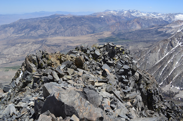
Inyo National Forest Locate the trail head. DAY 1 &nbps;|  DAY 2 &nbps;|  DAY 3 Day three. The moon got to just the right angle and woke me up again, but since the moon is lazy and takes a bit longer than a day to come around, it was almost an hour later when this occurred. Result, much better rested when I got up. I took a while to get up anyway. We were going to head toward Basin Mountain without any expectation to get up past the first lake because, as it turns out, I was the only one willing to bring crampons up. I lobbied for going up to Upper Horton instead. The valley looks a little rougher, but it was largely free of snow until the lake itself. I couldn't get any interest in that, though. My muscles were making complaints anyway, at least when not moving. Horton Lake again, but in a rare still moment. We're going to climb the valley to the left of the ridge until the snow blocks us. Upper Horton is up the valley to the right. We circled

Horton: Mount Tom

Image
Inyo National Forest Locate the trail head. DAY 1  |  DAY 2  |  DAY 3 Day two. The morning started too soon when the moon dropped down to a particular angle and the tent and fly were just not enough to block the light. Eventually, I decided to try to get a few photos and look for alpine glow in the morning twilight. There wasn't really anything but ordinary sunrise lighting. The view from my tent in the morning twilight as the first birds start to chirp and the bright just past full moon still hangs in the sky. Dial the exposure compensation way down and I managed to grab a hand-held photo of the moon, scars and all, setting with a few tries. Brightening rocks as the sunlight moves down the valley wall and a waterfall of snow melt.

Horton: Horton Lake

Image
Inyo National Forest Locate the trail head. DAY 1  |  DAY 2  |  DAY 3 I was given a chance to head to the Sierras and bag a couple of peaks in a three day bit of backpacking a week ago and had to jump at it. The snow pack is so low this year that the high peaks are already fairly clear. The plan was to head up and grab a permit for Horton Lakes and climb the old mining road to the lower lake for the night. The next day, up to our pick of Basin Mountain or Mount Tom, picking off the other one on the following day before packing back out to the car. I found it hard to believe that a trail head could be so little used that you could walk in around noon on Saturday of Memorial Day weekend and grab a permit for three, but at 11AM we walked in and did so. The other seven spots for the day's quota appear to have gone unused. There are reasons for this. The trail starts at the end of four miles of road that even the USGS map denotes as 4WD which comes after a couple miles o

Arroyo Seco

Image
Angeles National Forest We drove up Windsor and grabbed a spot on the side in the not-strictly-legal-but-left-unticketed spots in the painted out section of the lot. Getting a spot is always a matter of luck. Lots of people come here throughout the day, but many don't stay very long. Today, "we" includes Suzy and her two boys. It seems hiking with a small child before served me well in what to expect this time. Suzy hadn't been down this trail, but I suspected it would be quite good for our small group. We skipped over the JPL driveway and snaked past the gate and started down the pavement. We thought we were clear of traffic after the gate, but the bicycles seem to zoom past. The first bridge is a tributary with plenty of flow today.

Mono Campground area

Image
Los Padres National Forest We headed up to Mono for camping and hot springs. The road is currently open and since there wasn't any water in the ford, it doesn't look like it'll be closing for the frogs this year. The web site even indicated that the road was open all the way to Little Caliente. Although people have clearly been driving all the way up, the road closed sign still stands across the road at the ford of Little Caliente Creek. We headed up for a moon light soak in the waters, then camped at Mono and had a poke around toward the jungle the next day. We didn't go very far, and disliking the rather abundant poison oak swishing at our legs, took a plunge through a spot clear of the stuff into the creek bed. We'd seen very little water coming over the debris dam and much of the bed looked dry. Nothing to see here, as far as water is concerned.

Hostetter Fire Road

Image
Verdugo Mountains La Tuna Canyon Park I headed down to the Volunteer Fire Lookout training and, since it's easy, decided to stick around overnight to hit the trail, or rather the fire road, with the geeks the next day. It's a bit of a dreary and hot hike usually, the sort taken for exercise rather than the great sights, but this day had the weatherman threatening rain. We really had some sprinkles at the start too. Getting a bit of the way up the mountains and looking back over Sunland below. Lovely clouds are keeping it all nice and cool. The bee hives are still here.

follow by email