Posts

Showing posts from 2021

Annie & Mary Trail with Powers Creek Industrial Loop Trail

Image
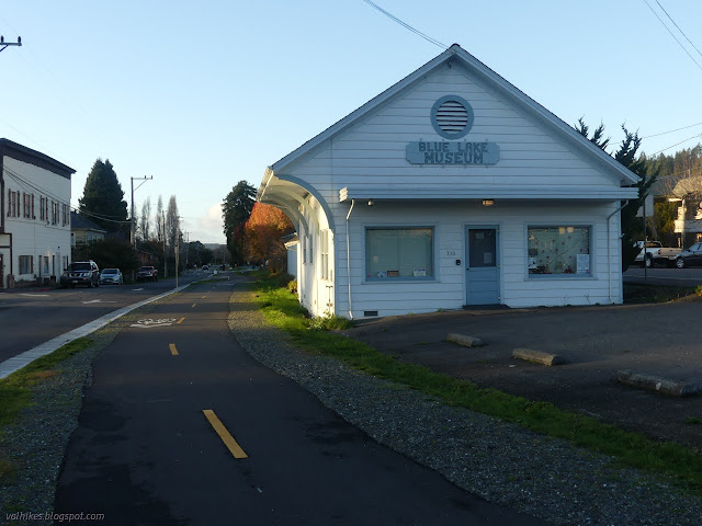
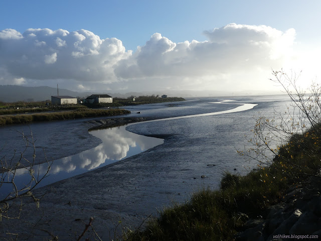
Blue Lake (map link) The Annie & Mary Trail is planned to stretch from Blue Lake to Arcata, generally along the old Arcata and Mad River Railroad route. It will form the northernmost 6.8 miles of the Great Redwood Trail , assuming that isn't derailed by Montana coal concerns . The first mile of multiuse trail was completed last year after some 20 years of work. (Getting a trail really is a long haul project.) Although it is paved and through the city, I decided I should go and see it. There is a bit of parking near the southeast end of the trail, but I actually parked way over on the far side of the bridge where quite a bit of parking, generally utilized by fishermen on the Mad River, can be found. The view from the bridge of the North Fork (ahead) coming into the Mad River (right). I then headed across the bridge and north, taking the right at the Y to find the start of the trail. This end of the trail is among distinctly historic buildings that I've driven past

Goodbye Timmy (1999-2021)

Image
I have to say goodbye to my most difficult hiking partner, Timmy. Not a successful backpacking trip. The sling is for carrying the cat. Admittedly, he didn't get to choose to be a hiking partner. He liked to see new places, but the long stretch of new, getting ever further from anything familiar was just too much. Also, he was already 20ish then, so I didn't expect him to walk the whole way. He wasn't too keen on being carried, either. He could make a 6 mile hike take the entire day, so most the time he just had to be locked away in the trailer. Poor guy. Tried letting him perch on the top of my daypack, too. But boy-oh-boy did he love camping. With it, he had all sorts of new places to explore, but had a familiar home base to return to. We'd get to a new spot and he couldn't be stopped from scrambling out to see where he was now. (Well, I suppose I could have tried harder as I did at gas stations.) He'd get going a bit further than I was quite

Klopp Lake and Brackish Pond at low tide

Image
Arcata Marsh and Wildlife Sanctuary with the lighter blue variations (map link) I decided to return to the marsh for low tide, which is a little easier to be impressed by than high. High tide just sort of hides things. It wasn't even a particularly low tide. It was about 2 feet and would reach 0, the definition of average for (low) low tide, with the sunset. There were a lot more cars in the little lot by the interpretive center this time. I headed out on the same loop as before , south to Klopp Lake. The wood posts that were part of various old development of the area now show the weathering that has left them ever narrower as it goes down. They are reflected in what is left of the tide retreating and the trickle of creek water. Butcher Slough was no longer brimming over with water. Klopp Lake is nearly emptied of birds. The birds were less keen about visiting the marsh at low tide. Klopp Lake didn't look any lower, but the they had mostly vanished from it. Th

Fort Humboldt

Image
Fort Humboldt State Historic Park (map link) I checked the Calparks site for Fort Humboldt to see that the park is currently "open at limited capacity", whatever that means. Perhaps no school bus trips will be around? There's only about a dozen parking spots for the public, and none of them has been blocked off. Then there's a list of what is open including the museum! So I said time to go again so that this time I can wander the museum. I neglected to get suspicious that the list also contains "beaches", which is an interesting inclusion since there are no beaches connected to the fort. The picnic area at Fort Humboldt. Not all of this was parade grounds at the time of the fort. I decided to loop around clockwise, going on the self guided interpretive trail first. This has the advantage of getting the signs in the order they were meant to be read. Once or twice, they assume the reading order, so it makes a little more sense. It also comes very

Shay Park

Image
Arcata (map link) I missed one of the wild parks around the city. Shay Park is stuffed with trees and winding creek and bridges. Old railroad tracks can be found along one side, so it will undoubtedly be part of the Great Redwood Trail when that is completed in the area. A blink-and-you'll-miss-it part, admittedly, but a part. It comes as the trail is bending east to the northern terminus in Blue Lake. The actual trail will likely follow the bike path on the other side of the park rather than the tracks exactly. One of the bridges, which are all different. The creek is Jolly Giant Creek, which was the water supply for the early city.

Klopp Lake and Brackish Pond at high tide

Image
Arcata Marsh and Wildlife Sanctuary (map link) While the tide was still hitting an 8 foot high and on a day when the sun would come out for it, I headed down to the Arcata Marsh to be impressed by all the water. Judging by parking at the interpretive center, it might be quite empty. Getting out on the trails quickly dissuaded me of that thought. There's always plenty of people out on the marsh. And dogs. Today, nearly all of their owners were even compliant with the local leash laws. Maybe there's enough birders around to remind those who can't imagine how such laws apply to their dog that "wildlife sanctuaries" are rarely okay with dogs being allowed to randomly charge the wildlife, no matter what their size or friendliness. Staring into the sun at the start of the trail where a map allows some planning. Butcher Slough with the water right up to the grasses and high on the old mill ruins. There's a couple different things that were built here over

Trinidad Head Lighthouse is 150 years old

Image
California Coastal National Monument (Map link.) Trinidad, with its sheltered bay, was a hub of activity in the 1850s. Founded April 8, 1850, it is the oldest town along the northern California coast. After a rather astonishing loss of life considering the size of the population, it was determined that a lighthouse should be built on the headland that protects that bay. The light was first lit on December 1, 1871, which makes this it's 150th year in operation. As such, a little extra activity was planned around the regular first Saturday of the month opening day. It is 3 days late, but when you've had that many years, a handful of days just slide. They planned to stay open 10AM-3PM rather than the usual 10AM-noon and had a few extra activities planned around it. People do seem to love the lighthouse and I was a little worried that it might test the parking area by the harbor, but there was plenty of room at the start. I was also needlessly worried about the king tides, wh

Five and Ten Divide trail work

Image
Klamath National Forest (Map link.) It has been a couple years since I actually did some trail work besides kicking the odd log and a lot of sticks off the path. There have been some excursions by the Siskiyou Mountain Club that got far enough south to tempt me, but none had worked out thus far. I noticed they would be working out of Clear Creek for five days and that sounded long enough to make it worth the drive. Is it odd that these California trails are getting a lot of maintenance by people from Oregon? Yep. I also notice that the folks driving out of Ashland are actually a couple miles closer to the trail than I am. I'm coming from another county too. Judging by the license plates on the way, it looks like more people from Oregon are using these areas too. In fact, you can find it covered in guide books for southern Oregon. Thursday The lower (last) parking area at No Mans Trailhead with the traditional burn area hazards signs marking the trailhead itself. The wo

Winter Backpacking in and around Humboldt

Image
I have only had one single solitary backpacking trip this year and it is not nearly enough. It has me thinking about winter backpacking opportunities in the area. I am specifically thinking about trips that, in a fair weather window, require no special winter equipment, although microspikes might still be a good idea. While you shouldn't need to exercise any special winter skills, the are still important to have. Weather tends to be a bit less predictable and a swollen creek will be more dangerous than one the same size that usually runs high. I'll start with some I have done, one way or another, then move on to trips that are speculation. These do happen to be reasonable summer trips, too. Keep in mind that while a trail may be low enough and not cross large bodies of water, access may still be a problem for potential backpacking areas. Anything over 3000 feet can have snow that sticks around for a while. Storms can bring snow levels down to 1000 feet and less. For elevation c

Double Janes Creek Loops

Image
Arcata Community Forest (Map link.) I headed off to the Arcata Community Forest to, uh, frolic along the creek. Give or take. For this hike, I started at the entrance off Diamond Drive. This entrance has parking along the street in a break between the houses. A dirt turnout provides a turn around and parking for horse trailers. (You do see horses from time to time in the forest.) The entry from Diamond Drive. Ah, the trees! (Ah, the stumps... it is second growth redwoods.) It is most decidedly mushroom season. I passed the spur to the parking on California Ave., which is not quite so easy to utilize, and looked for trail 10 (Vista Trail, but these names are only on the maps) to cut over to the top of the South Fork Janes Creek Loop Trail. I found it and quickly was reminded that it's a trail worthy of travel just because. It is quite a nice stretch through the forest as it dips down across a stream, then climbs again. A little at the start of trail 10. Trail 10

follow by email