Posts

Showing posts with the label Death Valley National Park

Corkscrew Peak

Image
Death Valley National Park (map link) (Not all of Death Valley National Park requires a fee, but this is within the old monument area where a fee is required.) There is no official trail up Corkscrew Peak, but it is sufficiently striking looking that someone decided it needed a roadside sign. I parked beside the sign where I found one of the many thin trails that converge onto a well worn use trail that climbs to the top. It's almost as good as an official trail. I was being promised morning weather including a chance of snow. I could believe it the day before as I explored Rhyolite under thick clouds, but I did the morning trail finding under an arc of solid blue. A very visible use trail going off to Corkscrew Peak in the distance. A couple puffs of cloud appearing over the top of Telescope Peak, far across the huge valley. The route drops into a wide wash where I could see remnants of trails from previous years. They all go the same place, into a short canyon with ...

Last Chance Mountain

Image
Death Valley National Park After another downright delightful night at the edge of Death Valley with the Desert Peaks Section group, it is again a short drive up to our start point, although a fair bit rougher than the drive on the previous day. The start is a cluster of mines in an area where there are quite a few mines. This one has many holes that look to be in quite good condition, one big enough to drive into. They are probably all the more dangerous for looking so safe. Holes in the ground are not our target anyway. We are heading north to a nice, high peak. And so we take off up an old mining road into a wide valley looking to gain a ridge and keep on walking. The road ends, for the most part, quickly at a set of large cairns. There is evidence of someone trying to find the way along it further up, but even that would not gain us much. Plenty of mining went on to give us our access point. We get some pinon pines along the side of the short road walk. ...

Sandy Point

Image
Death Valley National Park It is a good day for a Desert Peaks Section hike. The national weather service had predicted low 40s overnight and I did not wake up in frost for once. Well, I did not expect frost because desert air is good, dry stuff, but in this case it actually is in the low 40s. We are expected at the start point right around sunrise, so we rise ourselves into the pleasant dawn light. After some breakfast and checks and a short drive, we gather for the ceremonial signing of the liability waiver and general summary of the day's activities. The short version is we will walk along a ridge, tag a small bump on the way out, then continue on to the main attraction high above the Eureka Valley sand dunes. We then walk along the road a short way and, picking a spot, strike out into the wilderness. Roads and trails only go so far. Sometimes you just have to pick a direction and walk. This is easy travel country. For now, anyway. It is a long, gentle ...

Eureka Valley Sand Dunes

Image
Death Valley National Park I spotted a Desert Peaks Section (part of the Angeles chapter of the Sierra Club) outing included on the Hundred Peaks Section calendar and thought it looked fun and interesting. A little investigation showed that they still do not put any of their routes online like HPS does, but the schedule actually is there. Fine time to figure that out as the season for doing these is winding down and there may not be any for a while. As with HPS, you do not need to be a DPS member or even a Sierra Club member to join the outings. I signed up and even found a carpool for the long journey. It would require starting the drive at midnight to get to the traihead on time, so we are actually up the day before and looking about. It is a little warmer and not so windy on this trip to the sand dunes, but then it is the start of spring, not the start of winter. The sand dunes with nothing whatsoever to help understand the scale. Well, there is the little black do...

Scotty's Castle

Image
Death Valley National Park Locate the place. After an unforced error resulted in a an unplanned night on Hunter Mountain and some extreme good luck fixed the problem before lunch, we stopped by Scotty's Castle to find a gas station. Unless the 1920s era tanks are still legal, there is no sign of such a thing anywhere and strong signs the old AAA map is wrong. Still, we are here and it is a very silly place so we cannot exactly leave it again without having a look around. The place seems designed to evoke the idea of a castle very strongly without in any way being anything like a castle. The main house and some of the auxiliary buildings at Scotty's Castle.

Ubehebe Peak

Image
Death Valley National Park Locate the trailhead. We could see the trail to Ubehebe Peak switchbacking toward a northern saddle on our way back from wandering around the Grandstand. The trail is unmarked and starts from the same parking lot. A little examination and its worn surface pops out. The rock lined edges help pick it out. We found the start before leaving in the evening so we were sure of where to return to for a morning hike. Now we just start up it and see how it turns out. Ubehebe Peak (on the far left). The switchbacks can just be seen as a light colored zig-zag to the saddle near the right. The "island" of the Grandstand rises from the solid and dry mud of the Racetrack.

Racetrack Valley

Image
Death Valley National Park Locate the trailhead. The road into Racetrack from the north is best with high clearance although some were carefully making their way in passenger cars. We got to the parking by the Grandstand with the shadows getting long and walked out onto the dry mud of the playa (dry lake bed). The footprints of those who came when it was wet and ignored the sign warning against walking on it then are few, but well preserved. There are also tire tracks, both from when it was wet and dry, from those who really want to mess things up. The land is designated wilderness away from the road and the park does not allow off road travel. All these marks were fewer as we got further out. A single island in the middle of the lake bed is called the Grandstand.

junctions

Image
Death Valley National Park On the way to Ubehebe Crater, traveling the otherwise sign free roads, we came upon a crankshaft sitting upright at a junction. Assuming some of it is buried to keep it upright, a straight eight crankshaft. Off in the bushes, a pair from a V8 have also been contributed to mark the junction. We had obviously come to Crankshaft Junction. We have arrived at Crankshaft Junction.  Photo by Sung Byun. On the way from Ubehebe Crater to the Racetrack, we pass Teakettle Junction. Would we also find a tea kettle? We arrive at Teakettle Junction. Why, yes, we would. Quite a few tea kettles, in fact. The original that marked this junction is long gone, but many have been contributed to take its place. These are all dated and have messages. Only one is from 2013, the rest are 2014 and at least one comes from the other side of the planet. ©2015 Valerie Norton Posted 8 January 2015

Ubehebe Crater

Image
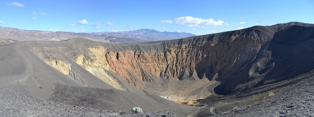
Death Valley National Park Locate the place. Our next stop is the Racetrack, but we cannot go past Ubehebe Crater without at least looking at it. It is a large hole in the ground and has similar, although smaller, neighbors, and it is quite the oddity. I look across at layers while a sign assures me it is volcanic in origin. Granite may flake away in layers, but I cannot pick out the edges of them if they are not flaking. I also look across and stand upon a dark layer that seems to have settled upon everything like grey icing. The layer seems to be cinders. The sign explains further about the volcanic action, how water sank down and met magma producing superheated steam that gathered until a weakness blew out this pressure cooker with no safety valve. Ubehebe Crater. One trail leads along the edge to the right and to other nearby craters and another leads along the edge to the left and down into the bottom. A circuit may also be made. We have a schedule to keep with ...

Eureka Dunes

Image
Death Valley National Park Locate the trailhead. Sung gave me a last minute chance to return to Death Valley and jumped at it. This did mean giving up another trip to Joshua Tree, but the logistics of finding a hike while others are focused on climbing rocks is not as simple as finding a hike with someone focused on poking around and hiking. The first stopping point is Eureka Dunes. We approached them in the late afternoon along the best road in, a wide strip of washboard dirt road the average passenger car would be capable of traveling. The dunes are at the far end of the valley on this approach, a sudden large pile at the end of a vast flat like some giant has just emptied his shoes after the beach. The mountains behind them make them seem small although they are some of the tallest, rising nearly 700 feet above the dry lake bed. They got more impressive as we got closer. A huge pile of sand rises in the distance. We settled into the camp, a place with a few concr...

Wildrose Peak

Image
Death Valley National Park (map link) When the plan was to join folks who were working hard to claim Telescope Peak, the plan for the day before was Wildrose Peak with a side of section corners since three of them lie near the trail. This is a shorter trail, so we put it to the day with more driving. At the trailhead, we get stories about the wind from those who stayed in Mahogany Flat the night before. It seems the wind was constantly strong with gusts of stronger and made for an interesting night. One fellow said he slept in his jeep which was lifting up in the wind. One of this friends decided that the good was good and the bad was good. In Wildrose Campground, the wind would slow down greatly and lull us into a sense of security before coming up and, say, picking up a glove off the table and tossing it halfway down the campground. We begin to worry if we might have to share the trail with the dozens of people who seem to be clustering around, coming from camping above a...

Telescope Peak

Image
Death Valley National Park Map link. Bernard did not want to go for another Sierra trip and decided he wanted to climb Telescope Peak from Shorty's Well over the weekend. There is water (way down around 3800) for camping although he really wanted to try to challenge himself and go for it as a day hike. I did not like the sound of it, but was willing to go up to the peak in the much more easygoing way along the trail from Mahogany Flat, or as near as I could get along a road where high clearance is recommended for the last two miles. Unfortunately, those who did like the sound of it at first eventually thought better of it and bailed on him. At the last minute, he decided to go anyway for the shorter hike and so Saturday, mid morning, we are up at Mahogany Flat and ready to start hiking. Looking down North Fork Hanaupah into Death Valley, for which the National Park is named. There goes Bernard, trekking past mahogany and pinion pine.