Posts

Showing posts with the label Wasatch National Forest

Yellow Pine Trail

Image
Uinta-Wasatch-Cache National Forest ( map link ) I wanted one more leaf peeping stop, so pulled into the Yellow Pine Trailhead. I must admit, the canyon had looked a bit grander where the trails tend to be built for ATVs, just a little before getting here. This is another trailhead that requires a Mirror Lake Recreation Area permit to park. There were quite a few vehicles parked there already, but many of them were actually there for a recently completed Slate Creek Trail, a one way loop trail for bicycles. I pondered it and discarded it. (Hikers are allowed, and even may go the wrong way.) With expectations of plenty of rain in the afternoon, my plan was simply to go until the rain started, then turn back. It would be really cool to get to either Yellow Pine Lake or Castle Lake, but it's not quite so nice when the views are grey with rain. A good place to start I decided to set both the GPS and the phone (using the Peakbagger app) to track the hike so I could compare an...
Provo River Falls and Slate Gorge

Image
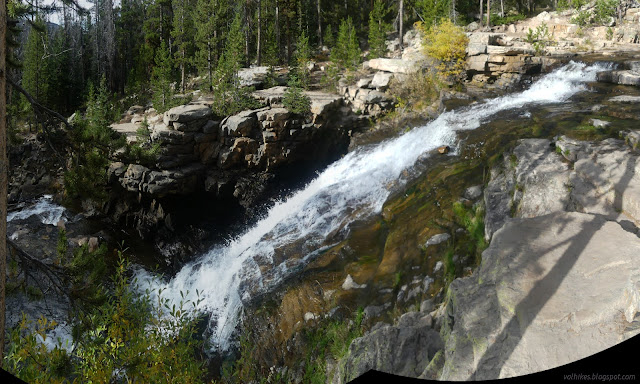
Uinta-Wasatch-Cache National Forest Provo River Falls ( location ) The sign for the falls seemed to be pointing at an iffy turnout, so I ended up hitting the brakes hard to make the actual turn into a paved lot with a bathroom. The parking requires a recreation pass for the Mirror Lake Area. (The turnout would not, though.) There's a couple signs about the importance of the area as a water source. The falls aren't a far walk, but there is a hill and some rough patches to get there. It's paved, but not accessible. Upper level of the Provo River Falls Patterns of erosion in this rock by the Provo River More of the upper falls, including parts hidden above I was expecting hard rain sometime in the afternoon based on weather I'd managed to download near Ruth Lake and again on Bald Mountain. The clouds seemed to already be getting set up for the deluge. It certainly wasn't ideal for photographs. Still, being there, I might as well keep going. There'...

Lofty Lake Loop

Image
Uinta-Wasatch-Cache National Forest ( map link ) Lofty Lake Loop was just too alliterative to pass up. The trailhead requires a permit for the Mirror Lake Highway Recreation Corridor like much along UT-150. I decided on a counter-clockwise direction because that would get me most quickly to the "ice caves" someone marked on OpenStreetMap. There's a big kiosk of information at the parking lot, but the Lofty Lake Loop trailhead is only marked with a little sign. The exceedingly clear trail climbs steadily toward a pair of lakes and Camp Steiner, which absolutely everyone actually calls "the Boy Scout Camp", some with an acknowledgement that the designation is out of date. Trails and an old road come up from the camp and all of these are marked with little metal signs. The casual hiker should be able to make all the correct turns even without a map. Picturesque Lake and a pond at its south end and "East Lofty Peak" rising behind But first ...

Bald Mountain

Image
Uinta-Wasatch-Cache National Forest ( map link ) Parking at the trailhead for Bald Mountain requires a permit for the Mirror Lake Highway Recreation Corridor. There's a pair of trails that leave from it, but I was planning on the one that most the other cars were also there for. Trail on the right with other choices to hike (Notch Mountain) to the left. It's not the end of the flowers! There's still a couple harebells among the wispy dried remnants. Autumn colors on the Provo River's valley. I headed up. There were people ahead, people behind, people passing frequently on their way down. I didn't want to take too long because the weather wasn't all that cooperative at the end of yesterday. So far it didn't seem to be making any threats.

leaf peeping on Main Fork Bear River Trail

Image
Uinta-Wasatch-Cache National Forest ( map link ) Parking at the trailhead for the Main Fork Bear River Trail at UT-150 does not currently require a Mirror Lake Highway Recreation Corridor permit, but it does require high clearance. I parked in a turnout across the highway on nearby Gold Hill Road. There's no signs on the highway for these. You need to already know where they are to get to them. I wasn't sure what to expect of the trail. The Forest Service topo indicates it crosses from Hayden Fork to Main Fork, where a road almost reaches the trail. The trail then continues upward to Hell Hole Lake. OpenStreetMap has the very different idea that it connects with a road and more trail continues after about 2 miles from the last river crossing. I would see. My plan was to get to the Main Fork, at least, and check out the leaves on the way. Forks of Bear River. The near crease is Hayden Fork and the far crease over the ridge is the Main Fork. I easily rock hopped across...

Hayden Fork Bear River

Image
Uinta-Wasatch-Cache National Forest ( location map ) I meant to have one more short hike for the day along the Main Fork Bear River Trail. This is another that does not require a permit for parking. Not yet anyway. It does require high clearance to get to the trailhead. I was almost lured in by the first 20 feet being paved. Instead, I parked across the highway and a couple hundred feet south on a turnout at the bottom of Gold Hill Road. This is another 4x4 road, but it has a turnout next to the highway and a staging area further up that are accessible to a small car. It started to rain as I drove down and as I tried waiting it out, it just rained harder and threw in flashes and rumbles for good measure. When it was done, it was an hour to sunset and probably less to full shadow. I decided to at least check on what the crossing of the Hayden Fork of the Bear River looked like. The area was stunning with the season and I can be excessive with the photos, so I've decided to incl...

Whiskey Creek to Bourbon Lake

Image
Uinta-Wasatch-Cache National Forest ( map link ) It's along the Mirror Lake Highway (UT-150), but no permit is yet required to park at the trailhead for Whiskey Creek Trail, across from Sulphur Campground. My map shows a 4x4 road going up to a spring that provides the camp with its water, but little is visible of this. The trail follows its own route from the edge of the highway. I wasn't yet noticing that because the aspens had become a little more abundant and were resplendent in their autumnal dress. A scattering of yellow aspens among the pines heading up the Mirror Lake Highway Then I started up the trail. It's a bit of a climb. Certainty in starting granted by a sign Kletting Peak across Hayden Fork Bear River The trail doesn't spend much time actually by the creek, but it does stop by it. Just past the first look is a short spur to a bench over the water. I took a moment. Why not?

Ruth Lake and Jewel Lake

Image
Uinta-Wasatch-Cache National Forest ( map link ) Parking at the trailhead for Ruth Lake requires a permit as part of the Mirror Lake Highway Recreation Corridor (UT-150). It even had a fee tube with a note that Saturday was a fee free day even if I ended up charged for it. (Grrr!) The trail rises its way from the highway to Ruth Lake in 1 mile, then continues upward to connect to Lofty Lake Loop on the ridge above. I had plans to visit Ruth and a few more lakes which have use trails visiting them. Where to start for Ruth Lake A little water makes a little waterfall There's a couple generic ecology signs along the way to make it an interpretive trail. Trees make oxygen, animals live here. If you take in such things often, you'll learn nothing new. Pooling water in a meadow along the way There's an old junction early on. I got to wondering where it might have gone once, but didn't get to exploring. There's plenty other space I was already planning ...

Hayden: Pinto Lake and Duchesne River

Image
Ashley National Forest Uinta-Wasatch-Cache National Forest (pink line, map link ) DAY 1  |  DAY 2  |  DAY 3 I woke up to another frosty morning, at least outside the area of the trees. I tried to follow trail out from the established camping area north of Pine Island Lake, but it hits a downed tree and runs out. There's no hint at the trail that people walk that way. Still frosty in the shade on the way out from Pine Island Lake. The trail crosses another bit of rock smoothed by glacier. Along with the trail signs at the north end of the Palisade Trail, I found a notice about "boreal toads", which it says have been vanishing. I think it looks like a western toad except that surely those aren't endangered. Well, it is the subspecies found in Utah and Colorado and they are endangered. (All of my observations of them have been in California and presumably the subspecies referred to as California toad. They're not endangered. Yet.) I wondered why th...