Posts

Showing posts with the label Gunnison National Forest

Turner Peak and South Texas above treeline

Image
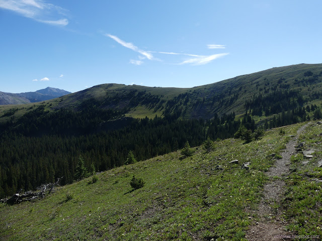
Gunnison National Forest San Isabel National Forest (map link) There seemed to be an astonishing number of backpackers coming south through Cottonwood Pass on the Continental Divide Trail given that it is still way too early for the southbounders, which isn't even the popular direction. When I got across the road, I found a post with a second crest and everything was explained. Of course! In this area, it is also the Colorado Trail. They're all Durango-bound, which is the popular direction, and it'll be time for them for a while. Starting off on the South Texas Trail from Cottonwood Pass, which happens to host the CDT and CT. Looking down the glacial valley of South Texas Creek. On the other side, the glacial valley of Middle Cottonwood Creek. The trail to Lost Lake can be seen wiggling its way through right in the middle. I didn't stay on the trail long. When I got to that first ridge, after enjoying the view, I took a use trail up to the first peak. ...
Cottonwood Pass picnic area

Image
Gunnison National Forest (map link) I was down in the cloud covered valley nearish Taylor Park and decided to head up to the picnic area near the pass for breakfast. It's a much better view. It has a small use trail from the bathroom out to the edge of the Collegiate Peaks Wilderness, and, if you look closely, a little further either up or down the ridge line. Taylor Park Reservoir still covered in cloud. Looking back along the use trail toward Cottonwood Pass. The ridge that is the usual, but certainly not only, end point for folks walking the trail by the picnic area. I looked out over the congressionally designated wilderness and took it into my mind to go there, where there was a massive green shoulder of mountain above tree line. The Collegiate Peaks Wilderness north of the picnic area. Trail along the ridge was hard to find at first, but then there was a sudden very clear piece that happens to come from the old picnic area. This is the one shown on my Fo...

West Elk: Soap Creek

Image
Gunnison National Forest DAY 1  |  DAY 2  |  DAY 3  |  DAY 4  |  DAY 5  |  DAY 6 (red line, map link ) It rained overnight, but that left me dry in my tent and my kitchen area dry under its little roof. Not that the sagging silnylon didn't try to at least wet my feet a little. I've got to try incorporating some elastic into the guylines to take up the slack as the silnylon stretches in the wet. Then again, the fact that it doesn't come that way has always made me wonder if it would really work. As is, it's a tent system that is weakest when most needed, and it's a universal problem with the material. I glared at the water seeping in where the fly sagged and touched the mosquito netting. What's the point of a double wall, again? At that point, it looked like to draw moisture through. But enough complaints about a tent that would be a great expense to replace. I could always go back to just the little roof and a bivy. It did w...

West Elk: explorations and Soap Creek

Image
Gunnison National Forest DAY 1  |  DAY 2  |  DAY 3  |  DAY 4  |  DAY 5  |  DAY 6 (orange line, map link ) I got an early start trying to beat the mosquitoes and sort of made it. I noticed the missing bit of sign on the ground to finally discover that there's no camping (or campfires) allowed at the lake. I turned at the post, ready to take it wherever it may go. The couple at the lake thought it was silly to think it might rain in the afternoon because the air was just too dry. Indeed, I'd washed two pairs of socks (in a bag well away from the lake and creek because I'm not a barbarian and I know soil bacteria is needed to break up everything from that and you don't find that floating in water) which were very nearly dry in the morning. It was quite pleasant until I got to the long grass meadows and everything from my knees down got wet anyway. A little bit of view over the meadow still shadowed in the morning. The trai...

West Elk: Castle Pass and Sheep Lake

Image
Gunnison National Forest DAY 1  |  DAY 2  |  DAY 3  |  DAY 4  |  DAY 5  |  DAY 6 (green line, map link ) I was wondering if this loop might be a little front loaded with the good stuff as I started toward the tree covered Castle Pass that represents the highest point for the second half of the trip. I expected it to be easier, although the state of the Castle Pass Trail was unique in that it not only showed recent trail work, but more trees already down on it than had been removed. It got better as I got higher. The camp site I should have found the evening before. Admittedly, it is closer to the trail than it should be. A little of the view from near the camp. Water pools in the meadow, but flows as a small creek beside the trail. From further along the meadow, The Castles and other pillars along the ridge top can be seen. I found a bit more water than advertised on the map along the trail. There was another, muc...