Posts

Showing posts with the label pass

West Elk: Castle Pass and Sheep Lake

Image
Gunnison National Forest DAY 1  |  DAY 2  |  DAY 3  |  DAY 4  |  DAY 5  |  DAY 6 (green line, map link ) I was wondering if this loop might be a little front loaded with the good stuff as I started toward the tree covered Castle Pass that represents the highest point for the second half of the trip. I expected it to be easier, although the state of the Castle Pass Trail was unique in that it not only showed recent trail work, but more trees already down on it than had been removed. It got better as I got higher. The camp site I should have found the evening before. Admittedly, it is closer to the trail than it should be. A little of the view from near the camp. Water pools in the meadow, but flows as a small creek beside the trail. From further along the meadow, The Castles and other pillars along the ridge top can be seen. I found a bit more water than advertised on the map along the trail. There was another, muc...
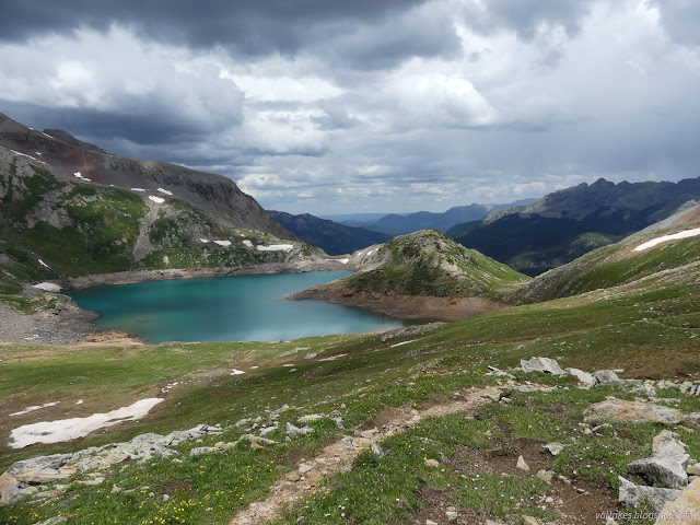
Hope Lake

Image
Uncompahgre National Forest (map link) The Forest Service seems to be uncertain if it is Lake Hope or Hope Lake, but more certain that it is the Hope Lake Trail. It consistently marks the road up to the trailhead as a 4x4 road, so I parked in a turnout at the bottom and started up, getting increasingly grumpy about how it is a rather good road with a loose rock here or there. I chatted with some campers about how it was probably great all the way up, but they'd gotten to their rather brilliantly picturesque site and been sufficiently mesmerized by it not to continue on. Talking with them got me sufficiently emboldened to actually stick out my thumb at the truck that came by as I finished the chat. When you're going 5 MPH anyway, it's easy to stop, and he did. Greg was going for the hike too and actually wouldn't mind having a buddy. The road promptly turned to something it wouldn't be wise to try the Scion on. With good judgement, I probably could make it, but...

Vallecito to Windom: Silver Mesa and Endlich Mesa

Image
San Juan National Forest DAY 1  |  DAY 2  |  DAY 3  |  DAY 4  |  DAY 5 Click for map. Morning and as I cook breakfast, I seem to have a minor mountain goat infestation of one male. These goats are far too comfortable around people. I watch him, and it becomes clear he's looking for a rock I might have peed on for the salt. Ew. One mountain goat sniffing about for a salty patch. The weather is already threatening, although I get a sense of rain without thunder somehow. The threatening weather is reason number one it might not be a good idea to take Endlich Mesa back as planned since after climbing to 12.6k feet, I stay near that and then over 12.8k feet Thimble Pass. That first bit of staying high is at least under a tall ridge, but the next miles high on Silver Mesa are above tree line in the flat. The next reason to avoid it is that fire warning at the start. The trails I came in on are hardly affected by the fire, but Endl...

Vallecito to Windom: Johnson Creek and Columbine Pass

Image
San Juan National Forest DAY 1  |  DAY 2  |  DAY 3  |  DAY 4  |  DAY 5 Click for map. Morning comes without any night rain. I totally got away with leaving the rain fly off. I didn't get much star gazing in, though. The camera said it had taken its last picture on the battery it had, so I pop in the charged one for a picture of the sunrise light on the mountains. The camera promptly explains that it has taken its last picture on that battery, too. I tested that battery before I started! I couldn't remember when it had been charged, so I put it on the charger. The light went red, then a couple minutes later it was green. I start to think that big camera plus 14er doesn't mix, but it went up Quandary just fine. It got up Uncompahgre and Wetterhorn just fine. It was only Williamson where I had a different problem. I seem to be rather emotionally attached to taking photos with the big camera because I feel a swirl of depression com...

North to South: Bishop Pass and South Lake

Image
Kings Canyon National Park Inyo National Forest Click for map. DAY 1  |  DAY 2  |  DAY 3  |  DAY 4  |  DAY 5  |  DAY 6  |  DAY 7 Two more days in the plan, but probably only one more day for the execution. I expect to stare at one more mountain that would be a perfectly reasonable climb, and then not go up it. The climb would make it late for getting out, so staying one more night would be nice, and the extra day would make time to go up one more little peak on the way out. Or I can just hike out today. I have minor, but unfounded, worries about leaving the cats with a first time carer for a week. The one needing pills can be a nuisance. So I may bail on the plan. Meanwhile, out in the Dusy Basin, it is looking like a very nice morning indeed. Surrounded by mountains, it is time to find the pass. I guess the bit at the left. Climbing higher, but still a few trees. There are lots of lakes, creeks, po...

North to South: Evolution Basin and Muir Pass

Image
Kings Canyon National Park Click for map. DAY 1  |  DAY 2  |  DAY 3  |  DAY 4  |  DAY 5  |  DAY 6  |  DAY 7 A lot of people have told me that Evolution Basin is the prettiest bit of the Sierras. There was even a day hiker coming up toward Piute Pass who said so. Today I will see it for myself. My shoes are not a lot drier after the night that seemed to have a bit of dew. My other camp sites were definitely a lot drier. It does not matter anyway. Crossing the tributary just up the trail while keeping my feet dry only lasts until finding the second, larger part of it. Who needs dry feet? And with the day's inaugural splashing, I head on to more meadows. Arriving at McClure Meadow. McClure Meadow is extensive and green and the creek sits within it like a long lake. I stand at the edge of the water for a while before noticing the flicker of ears in a nearby grasses. There is a small deer sitting behind it hid...

North to South: Lake Sabrina, North Lake, Loch Leven, Piute Lake, Piute Pass, Muriel Lake

Image
Inyo National Forest Sierra National Forest Click for map. DAY 1  |  DAY 2  |  DAY 3  |  DAY 4  |  DAY 5  |  DAY 6  |  DAY 7 A poor sleep, nothing to do with the moment and everything to do with being in a cycle of poor sleep, showed that all my little roof blocked was the very bright moon as it crossed the sky and then the view of the stars. A few clouds played, but mostly it was clear. Home seems to like to cloud up and rain at night, but these mountains like a good afternoon clamber with clearing at night. Still, the late evening activity hinted that there might be a little more to the current weather than just what the mountains generate. Morning is clear and George is shaded by the mountains with plenty of fish jumping. George Lake and a pothole beside it sit in shadows reflecting a morning sky. The trail along the side of the lake has a tree, still green, fallen across where it is difficult to get...

Jennie Lakes: Belle Canyon and Rowell Meadow

Image
Kings Canyon National Park Sequoia National Forest Giant Sequoia National Monument Click for map. DAY 1  |  DAY 2  |  DAY 3  |  DAY 4 It was another mild night, but the mosquitoes very nearly vanished early on into it. The sun comes quickly here and the morning golden hour is really quite something. I enjoy it with breakfast and happily the mosquitoes seem to be slow to wake up. Our northerly view from near camp: the morning sun as it hits Ball Dome. Morning over Ranger Lake. We head out to the trail again and wander gently downward, still high above the valley bottom. The air seems a lot clearer today and the snow on the far mountains is much more defined. The snowy distances.

Superstition Mountains: Peralta Canyon

Image
Tonto National Forest DAY 1  |  DAY 2  |  DAY 3  |  DAY 4  |  DAY 5 We are wet again in the morning, but we will not have to worry about that anymore. It is just a few miles to complete the loop. Phoenix was not so much an eternal sunset without any clouds for the lights to shine on. Fewer things are frosty. Swinging my wet bag through the air can make it frosty and help shake off the water, though. I make breakfast watching the light hit Weavers Needle and the rock pillars all around me. They take on the character of a stadium of people, especially with the sun hitting their "faces". Weavers Needle bathes in the morning sun. Looking up at some of the pillars around the valley. One of the high pinon pines sits atop the nearby rocks. We pack up and head out. Both the Beartooth Publishing and the 1966 USGS maps show a big switchback after the camp, although the first does not actually show the camp, that was goi...

Superstition Mountains: Music Mountain

Image
Tonto National Forest DAY 1  |  DAY 2  |  DAY 3  |  DAY 4  |  DAY 5 The night sure is long this time of year. Orion marches the entire length from east to west as the night goes on. Phoenix is like some sort of eternal sunset on the edge of the sky. Eventually the brightness in the southeast overpowers the brightness in the southwest and it is morning. A sky textured by clouds brightens in the dawn light. As we left, there was a 20% chance of rain for this morning. We expect nothing to come of it, but the cloud cover is nice. It helped keep us a little cooler yesterday and is doing a better job of that today. Not that the day has had much of a chance to warm up anyway. We get ourselves packed and start for the top, which is really just a few turns away. There are more and bigger spaces up there and the air has been very calm. Winds are always a worry at saddles, but last night would have been nice. The divide rolls...