Posts

Showing posts from August, 2023

Big Elk: Sky High Valley

Image
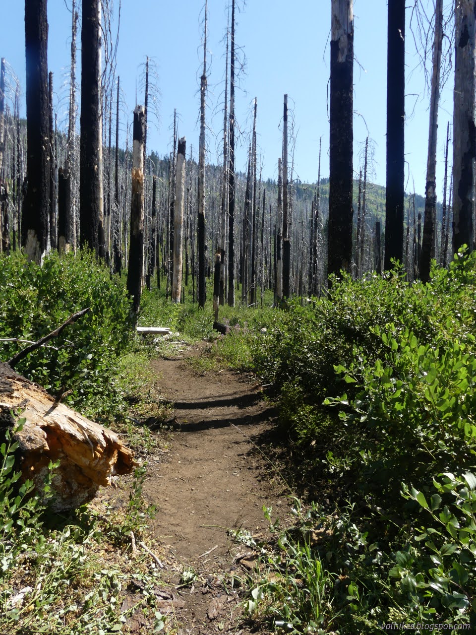
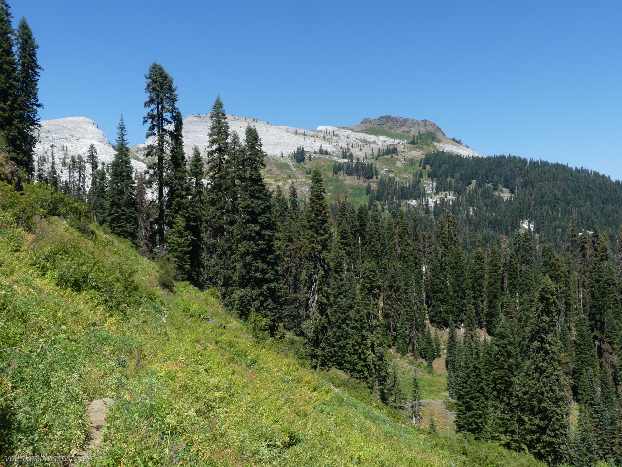
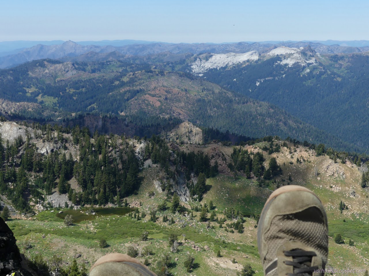
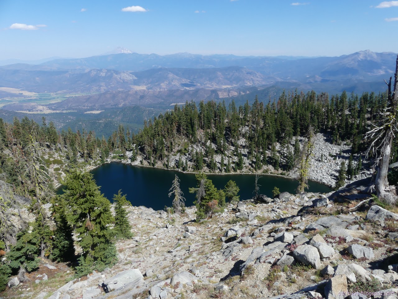
Klamath National Forest (dark purple, map link ) DAY 1  |  DAY 2-3  |  DAY 4  |  DAY 5-7 This third day was a rest day with people allowed to wander off on their own (or in groups) to do what they want and see what they might. I was rather uncertain what it was I wanted to do with it, but finally came down on the side of going to the top of Elk Peak, which is a p1k that I didn't have time for while passing by 2.5 years ago . I was hesitant because, again, the stretch of Haypress Trail that gets there is just not so nice, especially near Whiskey Camp. Over by the lakes to the west, it's wonderful. This bit gets a yuck. And it was even smokier. Morning on Big Elk Lake and even the near stuff seems a little smoky. We had a message that the Forest was removing their crews from the Wilderness. And what does that mean for us? If they've just decided they suddenly have different priorities for how they use their paid employees, it means nothing. If they've decid

Big Elk: working the Bigfoot Trail

Image
Klamath National Forest (blue lines, light then dark, map link ) DAY 1  |  DAY 2-3  |  DAY 4  |  DAY 5-7 We got up, had a breakfast that couldn't be beat, selected some tools, and headed off to the Bigfoot Trail. Through here, north to south, the Bigfoot Trail follows the Pacific Crest Trail (so it wasn't much of a stretch for them to work that bit) to Haypress Trail, but turns onto the Wooley Creek Trail quickly and turns of again at Big Meadows. Our target was this upper section of Wooley Creek. This first day would be logouts and a lot of brush so we had a lot of saws, big and little, and loppers. There's a few tread tools, too. The brush tends to ceanothus, but it's a nice deerbush snowbush that doesn't wear into hard, huge, sharp thorns like so many other ceanothuses do. Before: as we dig into the ceanothus. After: lovely clear trail! And apparently I was a bit too involved with cutting back the ceanothus throughout the day because that'

Big Elk: Canyon Creek

Image
Klamath National Forest (light purple, map link ) DAY 1  |  DAY 2-3  |  DAY 4  |  DAY 5-7 Finally on to the second week of volunteering with the Bigfoot Trail Alliance ! This one wouldn't be quite so varied in terrain as the first week in the Trinity Alps Wilderness . It actually wouldn't even be as varied as an earlier week in the Marble Mountain Wilderness where they opened up the trail to our camp at Big Elk Lake and did some maintenance on the Pacific Crest Trail. (Apparently the PCTA can't find enough folks to keep this area clear.) There's a lot from Humboldt, a few from way off south, but not many from Redding. They're closer and the big population center and after three of these, I just have to call it out. Where are the Redding folks? Maybe they're distracted by things to the east. The Bigfoot Trail boasts 32 species of conifer and we started off getting to admire a Pacific yew , the oddest cone of all these cone bearers. We had nearly

Boulder: Boulder Peak and Second Valley

Image
Klamath National Forest (blue and purple lines, map link ) DAY 1  |  DAY 2 With morning, I had a cold breakfast because I'd run out of everything for a warm breakfast on the previous trips. The sun arrived early and I packed up camp. Industrious thatching ants seemed to be packing the cracks of a nearby boulder with pine needles. The algae mats had mostly sunk again at Lower Wright Lake. I walked out on the track to the trail above, passing a rather official looking sign telling me of destinations higher up on the way. It has an impressive foxtail pine (Klamath subspecies, no doubt) as a sign post. I found the official trail with no trouble and continued up, mostly still in shade. Loads of mountain bog gentian , but still not open.

Boulder: Lower Wright Lake

Image
Klamath National Forest (brown line, map link ) DAY 1  |  DAY 2 After (mostly) bagging, the Russian Wilderness high point , and having once realized that Black Marble Mountain is not the high point of the Marble Mountain Wilderness while atop it , really getting the Marble Mountain Wilderness high point got a bit tempting. The actual high point is the generically named Boulder Peak and the usual approach for peak baggers is via a low standard road that gets one quite high up, around 6400 feet, on the way to 8300 feet. However, if one is limited by a vehicle with only 6 inches of clearance (like a Scion xA) and willing to do the climbing, there's a nice secondary road up to the Boulder Creek Trailhead right around 3800 feet. The narrow road was starting to feel maybe a little rough, but the little car made it with no mishaps the evening before. Camping can be had on a spur leading to the old ford of Boulder Creek (there's a bridge now) or just past the trailhead parking

Etna: Albert Lake and Pacific Crest Trail

Image
Klamath National Forest (blue lines, map link ) DAY 1  |  DAY 2  |  DAY 3 For my first trick this day, I figured I would pop up to Albert Lake, but probably not all the way up to Upper Albert Lake. For my second trick, I was aiming at a little more time on the PCT heading south to a saddle above Lipstick Lake and back. Finally, I'd pack it up and head on back to the car and get myself on to the next thing. I was kind of looking forward to the next thing, but first the current thing needed its due attention. I doubled back to where a trail had started to climb that was labeled as "Albert Lake Trail" on my OpenStreetMap. It got me right back to my camp and then up through the meadow and through the alders where someone had hacked them back a bit. There might have been a bit of trail there once, but it's certainly not where the people are going now. Paynes Lake Large patches are striped green with bur reeds . Past the swamp alder, I found a much better

follow by email