Posts

Showing posts from February, 2023

Beith Creek in flower and snow

Image
Arcata Community Forest ( map link ) We woke up Wednesday morning with snow falling. Big wet flakes were plopping against the ground after only half surviving the journey down and not surviving contact with the ground. More waves of snow came throughout the day, only sticking to the most exposed areas in a thin layer. As the light started to dim in the evening, it began to stick properly. It built up until the morning dawned with a blanket of the stuff. There was snow all the way down to the beach ! Things were less thickly covered by the time the sun got to shining a bit on the trees, but still plenty more than seen in a decade. A look along Panorama to a patch of backyard trees. The garden rhododendrons have been blooming a few weeks, but the wild ones won't be for a few months. Down the stub end of Margaret to another patch of private trees holding rare snow. Up the steps and into the community forest itself. Yeah, it's not all that much snow. Snow was on th

Iaqua Buttes Lookout

Image
(almost to) Arcata Field Office BLM ( map link ) I looked around the Kneeland area and concluded the Iaqua Buttes Lookout at the top of the highest of the Iaqua Buttes would be a nice place to go and a little over a day after a passing storm dropping a couple inches of snow down to 1000 feet might be a particularly picturesque time to do it. Well, assuming roads weren't too treacherous. The car managed to climb up one icy piece of road just fine, but wouldn't turn right to follow the curve of the road and stay out of the oncoming lane, so there was some treachery going on. I found a beautiful big parking area on the side of Kneeland Road just short of unsigned Slater Road to make my start. Back along Kneeland Road from the heart of working cattle rangelands Within 5 minutes, someone had stopped by to make sure I was okay (something that happens with disturbing frequency) and then informed me that this trip would be a failure. That county road goes up a little way and

If the Map's Wrong, Fix It!

Image
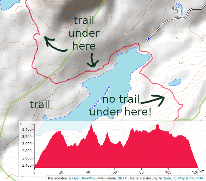
OpenTopoMap (an OpenStreetMap service) showing my GPS track from backpacking in the Flat Tops Wilderness in 2016 . It is zoomed into the busiest entry point where one very excellent and well used trail is missing. The map in question is, of course, OpenStreetMap . While not explicitly setting out to do this, they've created the Wikipedia of maps and you probably use it even if you don't know it. It's on AllTrails and Strava and behind Gaia Topo and MapBuilder on Caltopo. If any of those have an error, you can fix it. There in the lower right hand corner on AllTrails is the attribution and an invitation to change and add to the map. It's not just on the internet. This is also the one electronic map I carry with me, offline , that I know it will cover the place I am. When I need a library, post office, grocery store, gas station, I can search and find it even if I haven't got any usable cell signal. The roads are (generally) there. The buildin

follow by email