Posts

Showing posts with the label National Register of Historic Places

Dolason Prairie and Tall Trees

Image
Redwood National Park Click for map In the once upon a time, after backpacking around Redwood Creek , I stopped by Lyons Ranch and Dolason Hill Prairie . Then I only hiked down the trail as far as the historic barn, about a mile. I decided it was time to take on the whole trail. With temperatures climbing a bit inland and it being wise to consider this a mostly inland trail, it would be a warm day for it. The current conditions page lists the trail as only "partly open" due to downed trees. On the one hand, this page still lists the central portion of Rhododendron Trail as closed for the collapsed bridge that was cleared away and trail smoothed to make the small creek crossing easier years ago. It makes the bold statement that the seasonal bridges in Fern Canyon are both in place and removed. On the other hand, this is a National Park page and they might be better about the conditions of trails that are actually in the National Park, like Dolason Prairie Trail. (On...
White River Narrows

Image
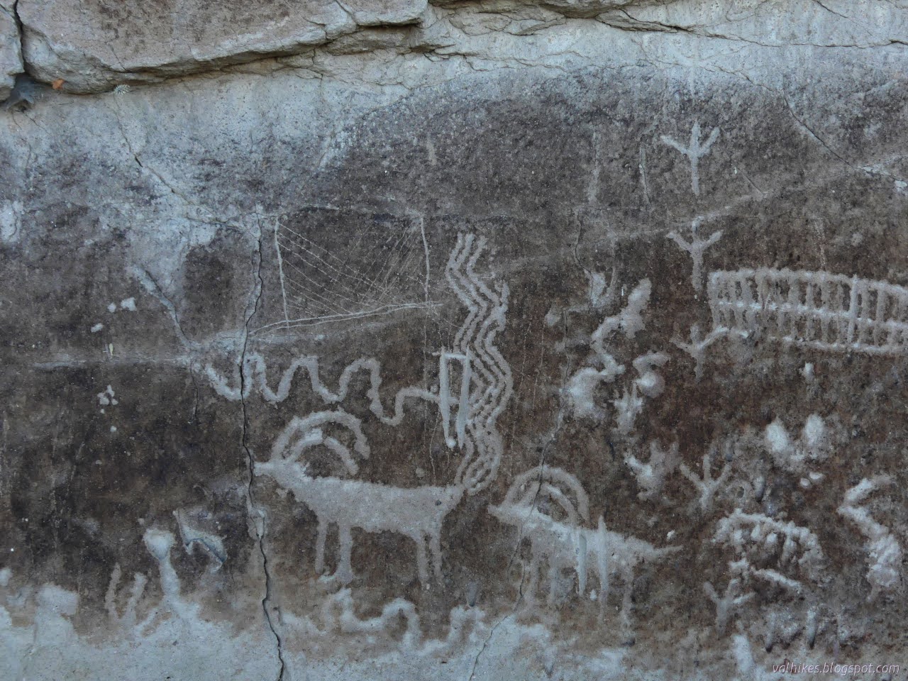
Basin and Range National Monument ( map link ) The three rock art brochures I picked up at the Caliente Field Office included one for the White River Narrows. When I had iffy signal, I had seen, but not kept, the printable map from this site . That would have got me to the sites, but the brochure has more to say about them besides don't touch, not even to take a rubbing. (But also, don't touch. Especially not to take a rubbing. It's illegal for a reason.) I did try to visit anyway, but it didn't work out well. I debated if I really wanted to backtrack out of my way 24 miles to try again, but while flipping through the Rock Art book from the Nevada Rock Art Foundation (also available in PDF here) , I spotted a particularly interesting panel and found it is part of the site here. Okay, I do. But first, this is what it is like to visit without the brochure in hand: 20 Nov 2023 I was traveling from the Wayne E. Kirch Wildlife Management Area toward Caliente with...

Loleta Tunnel

Image
Loleta Community Park ( map link ) I've seen that this hike is detailed in a couple news articles and blog posts and YouTube videos and Hiking Humboldt volume 2 and that it even has a geocache along it. It was seeing that the last barrier to the Great Redwood Trail has fallen and the right-of-way is now property of the Great Redwood Trail Agency (GRTA) that got me thinking more about it. It was seeing trucks marked "CCC" out on the rails clearing vegetation from the Humboldt Bay Trail , which is part of the Great Redwood Trail, that got me to come out and do it. On the drive here, I even spotted a sign claiming that the Humboldt Bay Trail - South was now under construction just south of the industrial park at Bracut. The north part of the trail currently ends at a missing bridge just north of Bracut. It all served to embolden me about this other little piece of the same right-of-way. The start of the trail in Loleta. In the newspaper articles, which are only a c...

Fetid Adderstongue on the South Fork Elk River

Image
Headwaters Forest Reserve ( map link ) I was experimenting with the Seek app from iNaturalist (I'll say something about it at the end) and remembered to check on the fetid adderstongue. I found a couple leaves approximately where I remembered, then a couple seed pods getting a start, then a burst of flowers! Well, three. Not great, but not bad. A second plant had one more. Blooming fetid adderstongue was meant to be my trigger to go looking for them above the Elk River last year . I spotted them near the Eel River mostly in seed and jumped for it worried it was getting late for their season already. I see so many more seed pods developing than flowers. There weren't a lot then, at least not that I found. I decided to try it again, but didn't expect much. According to the plant phenology reported on iNaturalist observations , February is by far the biggest month to find blooming, falling off sharply by March. I was actually the thought of maybe seeing salmon run ...

South Fork Elk River

Image
Headwaters Forest Reserve (map link) Since I had spotted the single blooming fetid adderstongue (and the two already seeding!) near Avenue of the Giants, I decided to head up one of the only real climbs around Eureka to see if I could find some more. I had seen many of them before, but all with drooping stalks to seed pods in May and June. It would be something to see all of them when the stalks are stiff and holding up flowers. Unfortunately, wheels were starting to turn and I might not be around for the more opportune time after mid-February. I started up that first paved mile. The South Side Trail was closed, of course, so there was no going around it. The barn along the way used for educational exhibits. The nearly obscured South Fork Elk River water level isn't very high at the moment. The paved ADA accessible portion of the trail ends at Falk after a mile. It gets a little more rolling for the next two miles. There is a slick mud section where land slides have ...

Eureka Waterfront Trail and 2nd Street

Image
Eureka City Park (map link) Sometimes, when it's been gently dribbling rain with scattered heavy torrents for five days straight, I get to thinking the sun is a lie. This is the real Eureka! It's not really true. Neither is the true Eureka because there's too much of both to leave out either. I decided not to stay in on the dribbly day and instead wander along the Eureka Waterfront Trail (including the bit in the middle I'd skipped before) and pop up to 2nd Street on the way out to see the old buildings. Other old buildings are available, but this one happens to have an "Adventure Lab" along it that points out a couple of the numerous historic plaques that tell a little about them. I started at the Eureka Slough unpowered boat launch, which is a small lot behind Target and put my umbrella up against the eternal dribble falling from above. The slough, the launch, the path, the highway, and the grey. I turned away from the highway and started along th...

Fort Humboldt

Image
Fort Humboldt State Historic Park (map link) I checked the Calparks site for Fort Humboldt to see that the park is currently "open at limited capacity", whatever that means. Perhaps no school bus trips will be around? There's only about a dozen parking spots for the public, and none of them has been blocked off. Then there's a list of what is open including the museum! So I said time to go again so that this time I can wander the museum. I neglected to get suspicious that the list also contains "beaches", which is an interesting inclusion since there are no beaches connected to the fort. The picnic area at Fort Humboldt. Not all of this was parade grounds at the time of the fort. I decided to loop around clockwise, going on the self guided interpretive trail first. This has the advantage of getting the signs in the order they were meant to be read. Once or twice, they assume the reading order, so it makes a little more sense. It also comes very ...

Trinidad Head Lighthouse is 150 years old

Image
California Coastal National Monument (Map link.) Trinidad, with its sheltered bay, was a hub of activity in the 1850s. Founded April 8, 1850, it is the oldest town along the northern California coast. After a rather astonishing loss of life considering the size of the population, it was determined that a lighthouse should be built on the headland that protects that bay. The light was first lit on December 1, 1871, which makes this it's 150th year in operation. As such, a little extra activity was planned around the regular first Saturday of the month opening day. It is 3 days late, but when you've had that many years, a handful of days just slide. They planned to stay open 10AM-3PM rather than the usual 10AM-noon and had a few extra activities planned around it. People do seem to love the lighthouse and I was a little worried that it might test the parking area by the harbor, but there was plenty of room at the start. I was also needlessly worried about the king tides, wh...