White River Narrows
Basin and Range National Monument
(map link)
The three rock art brochures I picked up at the Caliente Field Office included one for the White River Narrows. When I had iffy signal, I had seen, but not kept, the printable map from this site. That would have got me to the sites, but the brochure has more to say about them besides don't touch, not even to take a rubbing. (But also, don't touch. Especially not to take a rubbing. It's illegal for a reason.) I did try to visit anyway, but it didn't work out well. I debated if I really wanted to backtrack out of my way 24 miles to try again, but while flipping through the Rock Art book from the Nevada Rock Art Foundation (also available in PDF here), I spotted a particularly interesting panel and found it is part of the site here. Okay, I do. But first, this is what it is like to visit without the brochure in hand:
20 Nov 2023
I was traveling from the Wayne E. Kirch Wildlife Management Area toward Caliente with a few stops in mind. The first would be in the White River Narrows Archaeology District where there are petroglyphs. Some of them are marked on USGS. I parked at the northern parking area on the map above, a huge turnout south of the highway beside a pair of roads, crossed carefully, and let myself through the unlocked swinging gate on the road on the north side. The marked petroglyphs are not all that far north from there.
I was surprised to find that, according to USGS, I was walking on the main road. I'd already noticed that they had missed out the "1" in the middle of the road number. The dirt road is what is left of NV-38. It was replaced with paved NV-318 around 1980. It's just been that long and longer since some of these quads were updated and now there's a National Map instead. I could see where this old road used to be graded to 2 lanes wide.

I spotted a slapstick sign beside the cliffs and expected it to be a warning against disturbing artifacts. Nope. Wilderness. I would be visiting the Weepah Spring Wilderness, but only in the most superficial way. I continued north to the marked point. There was nothing. I looked further and further. Nothing.

I continued to find nothing. Nothing. More nothing. I walked back next to the cliffs rather than the road to be most sure of seeing something if I had passed it. Nothing. There's nothing.


So that was disappointing. It's right there on the map and I still can't find it.
I continued south to the far side of the narrows and turned to stop at a kiosk (the south parking area on the map above) that contains information about visiting the Basin and Range National Monument and visiting the White River Narrows Archaeology District. For this second, I should turn right (when going north) on the road with a cattle guard (yep, a cattle guard serves as a sign). I turned and looked down the road I was on to the only cattle guard on the roads by the narrows. From there, I should take the left at the Y. I looked the other way where there was a split in the road followed by another. It was silent about the second split. Anyway, it is weird for a sign to contain instructions to get to that sign. Maybe there was another cattle guard after all.
There were no brochures in the various boxes, and clearly I couldn't see the things when I got there anyway. With great frustration, I continued on toward Caliente, missing a few stops I'd planned and failing to find any trilobites either, once I got there. A frustrating day all around. At least camp turned out to be solid although traffic noise, which was fine this night, was a bit much the night before Thanksgiving.
26 Nov 2023
I had picked up the brochure (also available online here), and chatted with a poor young firefighter tasked with dealing with the public as the holidays came on and who had just been to see that panel I missed and didn't see how one could, and I had seen the interesting panel in the fancy rock art book. I was ready to try again. I parked beside the kiosk since the road gets a tiny bit rough for a Scion quite quickly. With my pack and brochure, I headed out to Narrows I.
There's a bit of distance to the first location marked, but after the first little hill, it's basically flat. There are no markers for these sites. The brochure gives a map and pictures of the cliffs near the site. With the landmark of the old highway, it should be enough to find each site. In the more traditional pattern of interpretive trails, it each site is written about separately after an introduction. Most sites are Basin and Range style, but one contains Fremont style.


Finding the location is particularly easy as those driving have provided a rough road right to the spot.


This first panel is simple and I'm all for simple and abstract, so it is pleasant to ponder it and ponder the words. Hunting magic or a solstice calendar are put forward as two very different possible explanations. This does make me think about forced boarding schools with rules against speaking one's own language and without that, the point of this bright not-so-old-as-the-others rock art might have just been a matter of asking.


Then onward around the looping, flat road to the next one.


I found another user road extending the outside round of the already looping former highway all the way to the area indicated by the brochure for Narrows II. It says there are four panels to find in the area. This one is also Basin and Range style, but contains elements unique to the area.


The other panels are smaller and harder to find. I'm certain of three, but not sure I found four, particularly the high one. One single low one actually looks like a modern addition.

I returned to the main road and continued around it to one more panel. Narrows III is also marked on the map by USGS. Now there is a turn around to mark the end of the road, a register (also with no brochures in it), and a trail to the large panel.


This panel has suffered through the years and is the subject of ongoing graffiti removal. Initials and dates seem to attract more initials and dates, so the disruption of removal could well justify removing the encouragement for more destructive graffiti. There is a particularly soft rock here, so particularly vulnerable. Some of the symbols are incised instead of pecked because of that soft rock. The bottom 2 feet or so might have to deal with the river, too. The rock is distinctly lighter and smoother there.

There's an antiquities notice beside the register and another beside the first great concentration of art. From there, the art continues on the changing faces of the rock for a very long way.


A walk along the wall is fascinating, but also depressing. Someone drew a target and recorded for generations their own great need for target practice. Thin scratches seem out of character for the old art and are also likely more recent additions. There is so much art here that the brain absolutely swims in it.

I missed a few by looking too much forward. They go around the corners and fill in every flat spot here.

I continued walking toward where the road now runs. The density reduced greatly, but there were still a few panels.


Once I got to the end of the line of cliffs, I ate and returned.

To get to Narrows V, I followed the road back most the way and took a small connector road over to the other canyon. I was really aiming at IV, but V works too.


After looking a bit, I realized I'd not seen a particular figure they called out in the description and got a little obsessed with finding it.


Narrows IV is visible from Narrows V, which made it very easy to spot. I headed cross country to it, finally crossing the dry riverbed in a way that made it obvious.

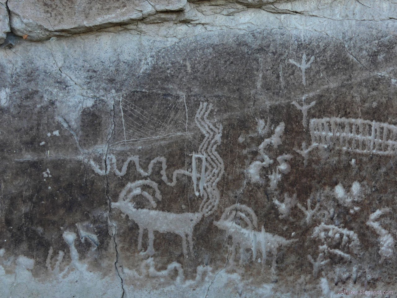
The blurb includes a mention of animals with longer necks that might have been a particular artist's style. Two lighter sheep to the left of the image below might be part of what they mean.


Then I crossed back over to the road and followed it back to the car. And did I want to try again for Narrows VI? May as well. I parked just about the same place as I had before, then made the northern march.

When I got to the USGS marked spot, there still weren't any petroglyphs. So frustrating. Okay, but what if I didn't have that information? Just working off the brochure information, I probably hadn't made it there yet. In fact, I walked more than twice as far north before coming to a fenced in rock face so crowded with rock art, it really would have been hard to miss. Well, unless you were looking for it half a mile south.

This site is known for the number of designs, stacked new on old. It is Basin and Range, but may have some Fremont style and there is one figure that appears to be the northernmost Pahranagat style. (Well, so says the brochure. A couple years have passed since printing.) And why do all that in one place when there is plenty of rock nearby? Well, clearly the placement of art takes more than just a blank canvas, it says.


Hum. Perhaps the lighter lower level is from a changing ground level, not flooding. Or not just.


That was satisfying, but also a little overwhelming. Good grief, there's a lot. I did not find the few special figures from other styles in the collection, but that's okay. It was getting late, and I headed back to the car.

Before leaving, I tucked the brochure into the box at the kiosk sized for it. I decided against braving the road to the Mount Irish Archaeological District, so tucked that brochure in next to the other.
*photo album*
©2023,2024 Valerie Norton
Written 26 Jan 2024
Liked this? Interesting? Click the three bars at the top left for the menu to read more or subscribe!


Comments