Lunar Crater
Tonopah Field Office BLM
(map link)
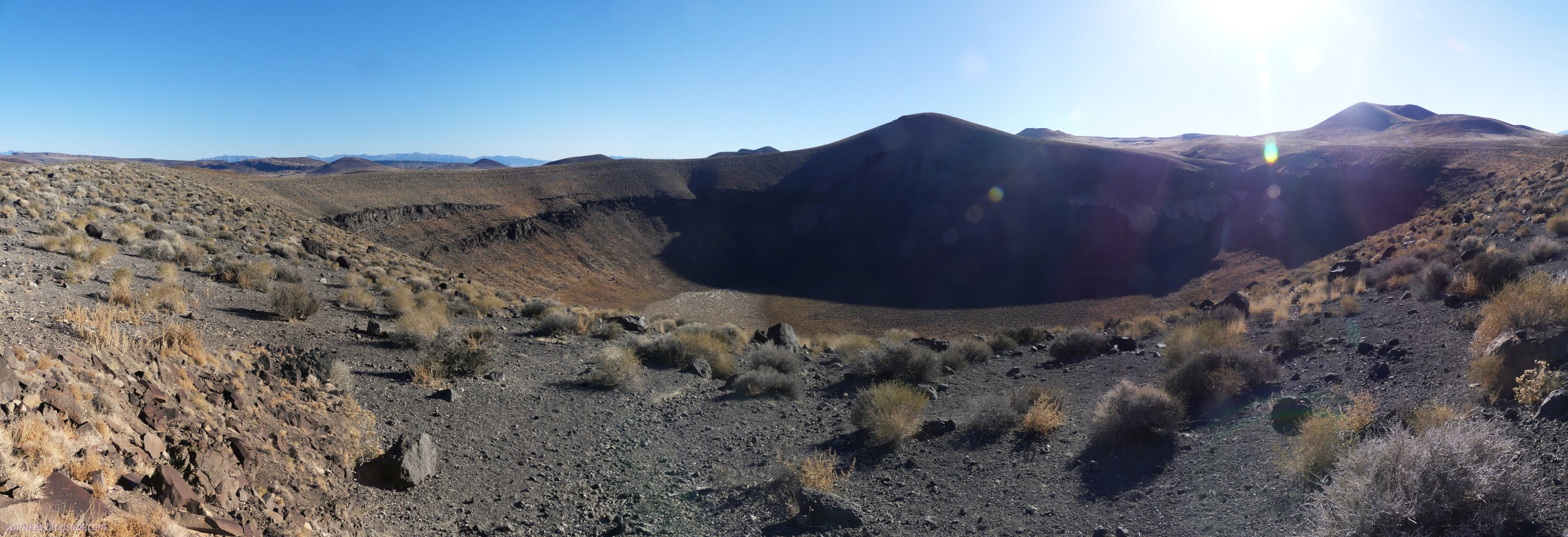
I traveled the Extraterrestrial Highway (NV-375) looking longingly at the several good roads extending north past varied and beautiful mountain ranges. All missed on this trip. It's much more interesting than the area to the south, which is off limits testing grounds and supposedly includes "Area 51". Circling around on US-6 and then following an actual sign for my destination, I arrived late in the afternoon at a small volcano field full of little craters and the odd lava flow. Among all these little cinder cones is one oddity: Lunar Crater, a maar crater.

While the nearby craters are formed from pressures deep within the earth finding a weak spot to spew new rocks, which then collect in the vicinity, the maar crater forms when water suddenly encounters hot magma and the resulting water vapor provides the explosive energy to blast away the rocks already there.
Stopping and seeing it is all most people do. Apparently they stick their stickers on the "Lunar Crater" sign, too. I had an Earthcache I wanted to do, too. It asks one to make a careful trip a short way down into the crater to have a close up look at the rim rocks. There's a break in that first hard layer to give a route for the confident off-trail walker. It also mentions that this was a training ground for Apollo astronauts once. (This is a rumor or a one time thing. USGS says astronauts trained in chemical and nuclear craters at the Nevada test site.)


I even had a tiny bit of usable signal to send off my answers for the Earthcache (and get a new weather report just as the old and increasingly far off predictions ran out). I followed a wide trail west of the parking area to find a memorial bench, so there's a place to take a little longer to contemplate the area.


I decided there was just enough time to take a trek around the edge of the crater before sundown, so I set off on a distinct trail continuing past the bench. The only complication is the little bit of a creek bed coming off Citadel Mountain to the south.


The complication wasn't all that complicated. I found a nice almost trail on a nice ledge of rock to drop to it and then cross.

On the far side, I decided I may as well tag the minor peak there on the edge of the crater. It could have a bit more view, after all. I'd nearly go that far anyway.


I found better views a little north of the high rock outcrop where the crater is more visible.


I followed a rough trail down the steep hill on the east side of the bump. It arrived at the road at an excellent flat spot for camping, and clearly it had been used as such. From there, it is road all the way back, passing a second perfectly flat used camp. The shadows were taking over quickly.


So I arrived back and there was indeed a little light left over, most of it colored in reds of sunset.


Then off to find camp. One of those camps I had just found might have been nice, but there was a hint of wind in the air and in the fresh forecast I'd got and I wanted something more sheltered.
*photo album*
©2023,2024 Valerie Norton
Written 28 Jan 2024
Liked this? Interesting? Click the three bars at the top left for the menu to read more or subscribe!


Comments