Posts

Showing posts with the label LPC

Montecito Peak

Image
Los Padres National Forest Click for map. I feel like I have been avoiding the front country since the Thomas Fire except some brief looks early on. I see it on regular evening hikes with folks during the Wednesday conditioning hike and the Friday social hike, but I tend not to write up those hikes. Before leaving easy access to it, I decided to hike up Montecito Peak one last time. The usual approach via Cold Spring Trail is still closed, so the easiest entry to climb the peak is now Hot Springs Trail instead. The exclusion zone signs at the bottom have now vanished, so things are getting better. The very start of the trail looks the same, but things change just a step past that. New fencing is everywhere replacing what was washed out to sea. The creek flows down a canyon deeper and rockier and more open to the sun than before. The creek actually flows, which has not been seen this late in the summer in recent years. For one familiar, it all feels different. For someone who...
Santa Cruz: Santa Cruz Trail

Image
Los Padres National Forest DAY 1  |  DAY 2  |  DAY 3 Click for map. The map has reminders that when I have thought about being here at Santa Cruz Station in the past, I had wanted an extra day at least to explore. Down the creek, it claims there is a cabin to be found. Up the creek are waterfalls. The register box has a note pad and someone noted not just the waterfall (which they liked), but some rather large trout up there too (and they liked as well). I decide to note that someone should come down the fire trail with a chain saw. Or at least some flagging. Especially for the flatter areas. After a little more poking around, I am off. Had I not been planning to go out by the trail already, after coming down the road, I would have changed my mind. So that is via the trail. The trail junction. I went north yesterday, now west briefly before heading south. The old Santa Cruz Guard Station is kept locked up tight when volunteers are not using it. ...

San Rafael: Big Cone Spruce and Cachuma Mountain

Image
Los Padres National Forest DAY 1  |  DAY 2  |  DAY 3  |  DAY 4  |  DAY 5  |  DAY 6 Click for map. I awoke in the dark to mist on my face. The night had been clear with bright stars shining where I could see through the leaves, but had turned dark. My light showed more mist coming down. It was raining. I could see quite a bit of water on my quilt already. It had been raining for a while. I looked around for some rocks to hold down the emergency blanket again and saw a blanket of white developing. It was actually snowing. The breezes of the evening had died to nothing and it was the most peaceful moment looking out on that fluff dropping down. And then I had to get up and deal with it. The emergency blanket is a lot easier to deploy a second time, so I got it open, got some rocks to hold it down, and tucked in underneath my rain coat to sleep the rest of the night away and get up to a blanket of white. It is an all new ...

Rocky Peak

Image
Rocky Peak Park Indian Springs Open Space Click for map. I am not entirely sure how it happened, but we finished planning the outing for yesterday with plans for today as well even though there was never any question as to where or when the other would be. It is a much smaller group today with just Scott, who was generally the instigator of plans, and Linda, who decided to hike just today. Linda brought along Milo, who should be good for sniffing out geocaches and better be a good hiker because we should come out around 10 miles again today. She says that he is. I joined up because this hike swings past Rocky Peak, which is on the Lower Peaks Committee list and has a county line marker up on top. It should be a little harder to get to than the one I nearly tripped over by Random No. 2 , but a bit easier than the one up on top of Dome Mountain . Scott has been before, Linda seems so disinterested that she forgets a peak was mentioned within seconds. Milo seems ready to get to w...

San Mateo Canyon: Sitton Peak

Image
Cleveland National Forest Click for map. DAY 1  |  DAY 2 Everything just looks a little hotter, so I think this 3 day, 30 mile plan will require more water than the one I just pulled off in Agua Tibia Wilderness. Although it looks more likely there could be water here, the map indicates all streams are seasonal. Since I could get no information on either water or the state of the Bluewater Trail, marked as unmaintained on the wilderness map, I have to plan as though there is no water and Bluewater could be difficult travel or navigation. The result of sitting down with the map and some mileage information that is helpfully supplied on the trailhead sign is to cut off 5 miles and the unmaintained part so that travel will be more certain and it is doable in 2 days. This leaves me confident enough to leave one bag of camping water, but none of the hiking water. Starting water weight is still 20 pounds and am considering this a rather minimal amount. Water plannin...

San Mateo Peak

Image
Cleveland National Forest Click for map. I arrived at Morgan Trailhead and started stomping up and down the first few hundred feet of trail and glaring at the gentle rolling hills covered in short chaparral. I was pacing, really, wondering if I really want to do this again. Do I want to load up my pack with three days of water, again, to hike another dry wilderness? One that looks a fair bit hotter than the last as I will be losing elevation along the way rather than climbing and the elevations here are lower overall. Maybe I should just drop it and go home. Still, I had the whole afternoon. When planning, I had noticed I could hike a nearby peak and thought I might if I had time after. It is only about 2 miles, so I have time today. I could at least get something out of being at the trailhead and gain a little more perspective on what is here. Surely there is a bit more than gentle rolling hills covered in low chaparral. A hidden sign found shortly after finding the unmar...

Agua Tibia: Eagle Crag

Image
Cleveland National Forest Click for map. DAY 1  |  DAY 2  |  DAY 3 It was a mild night and with the sunrise, I can have breakfast in bed. Or actually, make breakfast in bed, but then pack up my gear while the pistachio pudding full of coconut and chia seeds "refrigerates" in the morning chill. My water looks so low. I used 4 of 2.5 liters for the hike up. There is still enough to go up Eagle Crag, and then I will be right back here and can evaluate it again. Perhaps if I can hike it with just the water left over from the second bag of water, then it will be fine, so I set that line and eat my breakfast. The new view I hiked to last night. The only city lights were in that blue distance. Eagle Crag, the goal for the day, stands in shadow against the brightening sky. I toss in another bag of water and what I need for day hiking. With my gear and extra water tucked away, I am ready to hike nearby Eagle Crag. I still see none of the poodledog tha...

Agua Tibia: Wild Horse Peak

Image
Cleveland National Forest Click for map. DAY 1  |  DAY 2  |  DAY 3 Researching the Agua Tibia Wilderness, I found it may be a rather tough backpack. Its namesake looks to be very difficult to obtain from anywhere. It looks like my most likely chance is a stream that I will come to while technically outside of the wilderness. There are a couple springs on the map, but they seem rather close to some black squares of buildings. Looking on satellite, there do seem to be a couple of homes next to these possible sources. As if to drive the point home, my permit specifically calls out for the respect of private property in the "special notes" section. That eliminates the best bet. I will have to carry all my water for three days. I have found and filled a total of five Platypus bags to take. One to hike, one to camp, one to hike, one to camp, and one to hike. Camping actually takes less than one and hiking down will not need so much either, but the other two hi...

Montecito Peak

Image
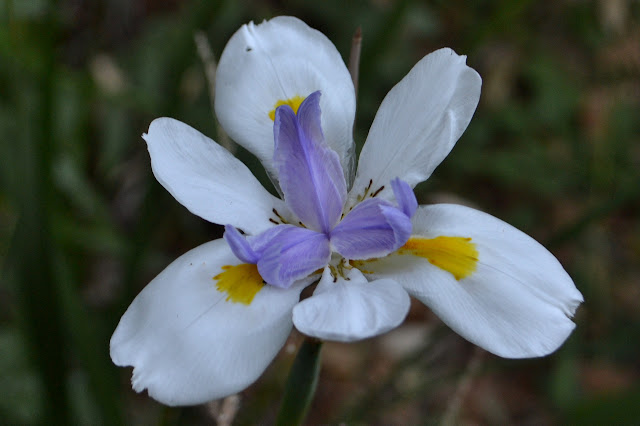
Los Padres National Forest Trailhead location.  (See previous Cold Springs East Fork or Montecito Peak trips for maps.) The local Sierra Club chapter has a weekly conditioning hike every Wednesday evening, inviting all who feel capable of a 6-10 mile hike to meet at the Mission at 6:30 PM. For around the solstice, we have been doing a couple special hikes. Last week, we climbed up the use trail from Jesusita Trail to Cathedral Peak, then continued on to La Cumbre at the top. It would not have been a good trip for a new attendee. This week is a party up on top of Montecito Peak. It would be much more appropriate for a new comer and similar to one hiker's first hike ten years before. I request heading up along the creek rather than the old guerrilla trail and no one else has an opinion, so that is what we do. It is a half mile longer, but keeps us out of the hot sun longer. It also offers some flowers to help celebrate the start of summer. A single iris in the canyon,...

Redrock Mountain

Image
Angeles National Forest Link to map. Redrock Mountain really catches the eye when viewed from the west side where its deep red heart is on display. Since I have plodded along on a few trails that do this, the mountain has eaten into my consciousness. The area around it was once quite popular among hikers and each excursion I have done around its base has shown me new reasons why. Today, any entry into the area requires first a mile along paved roadway before getting to a trail that can get one to the good stuff. It tends to weed out anyone who is not looking for a long hike. Today, I am looking for a long hike. I will head up Fish Canyon and climb that mountain, then return via Redrock Canyon and (Old) Telephone Road. A previous excursion that returned via Telephone Road lead to a bit of disappointment in being only able to see some of the beauty around me because it was already getting dark. Timing for off trail travel is uncertain, so I could end up in the same situa...

Malapai Hill

Image
Joshua Tree National Park We were left with most of the afternoon to get to camp and set up before the party would start around dark. That is more than enough and there was an offer to pop up Malapai Hill, so I jumped on it. This is a little bump in the middle of a plain the Geology Tour Road goes through and is strikingly different from the other little bumps in the area. It was pointed out to me when I did Bernard and Little Berdoo during a previous Holiday Hooplah and looked like a reasonable and easy thing to climb. We are warned that the footing can be iffy before heading off and told that there is supposed to be a benchmark on the lower peak as we arrive. Malapai Hill is a lump of small, dark rocks in the middle of a desert flat where most the lumps are large light rocks.

Jupiter Mountain

Image
Angeles National Forest The stars are still not aligned for Jupiter Mountain. The low chance of rain looks rather like it will materialize, although the amount may not be much, and it is a bit colder than expected. The clouds are low over the mountains, but not so low as the peaks. There is some slight promise of clearing. Where the mountains stop and the flat desert starts, there is a bit of blue visible. The potential of rain seems like a stronger promise. Parking is easy in a large turnout at the bottom of Spunky Edison. The trail is unmarked as it starts climbing past a water tank. The trail starts among a grove of pines that appear planted. It starts off looking like road. I go left; the other side loops through the trees that occupy the saddle. The ground is terraced and the trees are unique to the area. It could be an old tree farm. The trail passes a water tank and splits again. This time I go right and shortly find the climbing thin track I am expecti...

Simi Peak

Image
Lang Ranch Open Space Oakbrook Regional Park Santa Monica Mountains National Recreation Area Woodridge Open Space The original plan was a shuttle hike along the Albertson Fireroad, but the instigator of that plan decided against hiking today after all. By bending the route around, I could get the peak, so I went for much of that original plan anyway, just removing the need for a shuttle. There is plenty of parking at either trailhead and a packed dirt path connects the two. I choose to start at Oakbrook View Trail, which comes first along the road. The sign is offset from the road, but it is still easy to find at the start of some park areas. An open space across from a park where a line in the grass leads to an information sign. I will start here. The trail starts climbing through oaks up a little hill. Houses built on a few different plans stand in neat curves below, but not for very far. Grassy hills surround the neighborhood. A light mist lingers in the gen...