Montecito Peak
Los Padres National Forest
Click for map.
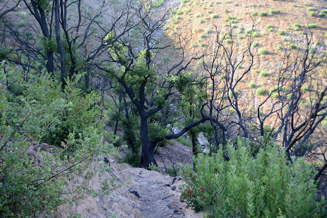
I feel like I have been avoiding the front country since the Thomas Fire except some brief looks early on. I see it on regular evening hikes with folks during the Wednesday conditioning hike and the Friday social hike, but I tend not to write up those hikes. Before leaving easy access to it, I decided to hike up Montecito Peak one last time. The usual approach via Cold Spring Trail is still closed, so the easiest entry to climb the peak is now Hot Springs Trail instead. The exclusion zone signs at the bottom have now vanished, so things are getting better. The very start of the trail looks the same, but things change just a step past that. New fencing is everywhere replacing what was washed out to sea. The creek flows down a canyon deeper and rockier and more open to the sun than before. The creek actually flows, which has not been seen this late in the summer in recent years. For one familiar, it all feels different. For someone who has not been here before, it probably would not seem so strange. Repairs have been made, at least on the edges.

From previous Friday hikes, I know the trail goes through, although there has been a little bit of work to make it do that and there is a spot in the middle that gets a little confusing. It just makes the best route hard to discern, it does not make it possible to get lost. Seeing it in the light is a bit different. There are views all over that previously were just a wall of vegetation.


From a Wednesday hike, I found that the trail above the old Hot Springs Club has at least one tough spot, at least when traveling in the dying light of the evening. Instead, I head up the Edison catway to get up to the upper portion of Cold Spring Trail, which is in fairly good shape. It may be a little further, but not by much. It quickly rises above the few trees left in the canyon and out onto the cleared hills.

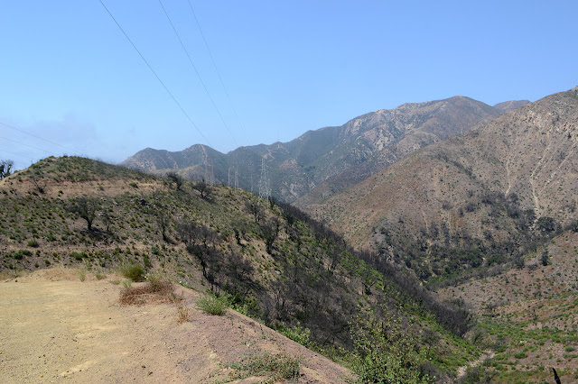
The trail as it climbs from the road is looking soft and initially quite steep right by the road. Quickly, the trail bed itself looks familiar, if a little bit sandy, but there is virtually nothing remaining of the vegetation surrounding. Plants are regrowing from their roots quickly, but the result is sparse.


Rutted and rocky and rocky and rutted, the old trail is holding as well as it ever has. The traffic on it seems to have reduced, but the masses before have left a very long lasting mark on the land. I expect they will return in similar numbers soon. That pair of eucalyptus trees 2.5 miles up, though non-native, are one of the things I wondered and even worried about. Both burned. The larger one seems to be springing forth with leaves from every surface the same way burned oak trees do. The smaller one fared worse and only has growth from one small section while the rest seems dead.

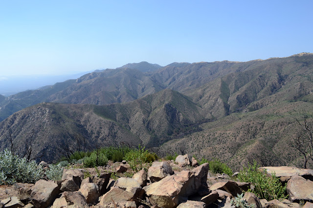
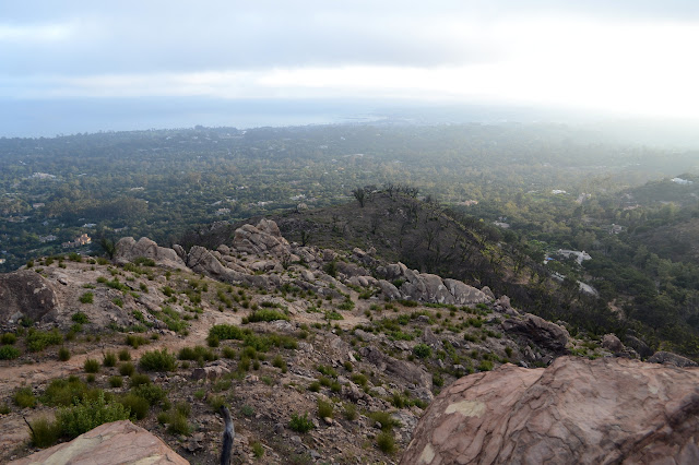
The use trail that climbs up to the peak is looking far more used than the official one continuing on to the saddle above. Even this trail does not seem all that much worse for having been savaged by fire and flood. There are spots I feel a little less comfortable on, but it has always required a few uncomfortable steps on steep hillside. The poison oak along the way is coming back with surprising vigor. And after a short, hard trudge directly up the steep side, there is the top.


The pine, planted and cared for by hikers at the top, now is a blackened stick with blackened branches and a few black cones at the top. It will not be coming back from the roots. It looks like the register was moved to a spot that is meant to have a geocache. This is unfortunate, because it likely would have survived in its usual spot. Now there is an iron bar and springs; from pens, a flashlight, and the spiral binding of note pads; left of it. I head down, past a burned up folding shovel and back to the official trail. It looks a little like people have been walking the southeast ridge, but I elect not to try that.
I do elect to try the trail down to the old Hot Springs Club, though. There are a few footsteps on it and even a bike track. The top portion of the trail seems quite good although I am rather worried that this is just to lull me into a false sense of security. Then again, the bike does not seem to have come back up. If a bike can do it, I can do it.
The trail looks like it will let me down as it starts across a south facing slope, but when I get closer, it does not look so bad. There is tread all the way to a spot near the hot springs. It used to curve around the canyon above the how water welling from below. Now I have to drop down awkwardly to get next to a pool, find a way across, then climb up a little less awkwardly to get back to the old trail. I squeeze past some bay trees regrowing from their roots and follow a bit of erosion to make the first drop a little shorter. It seems like a sensible thing to do. The first drop presented is quite high.
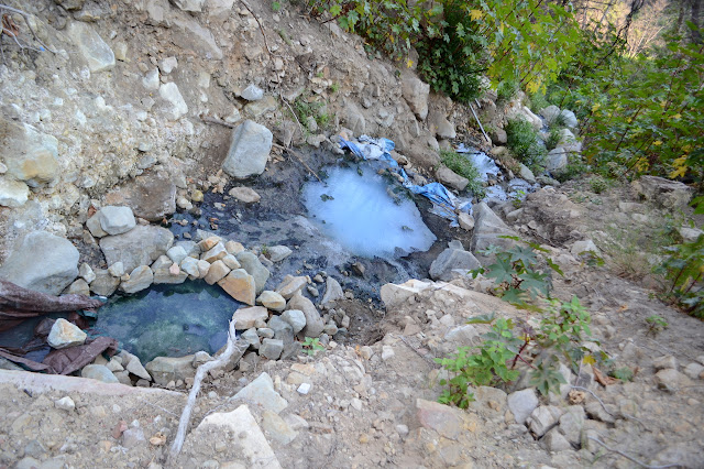
The rest of the trail is better traveled just because there are a lot of people who come up to the pools. No one has done any work on it, though, and it really needs some. As it hits the creek again, it is another very awkward transition to get down off the trail on the hill side. The old hotel is changed very little since it was already burned down so long ago. Some of the old timbers surrounded by rock seem to have popped free.


From the old Hot Springs Club's hotel site, there are a few ways back, so I do not have to retrace much of my path up. The direct way is along the road, but I decide to go for Saddle Rock and walk across the top of the hotel and past the palms where there used to be trail that meets the road without much loss of elevation. The loss is on the old entry steps that tend to be covered over with dirt and a little looser and steeper than desirable. The palms seem to have all fared differently with one dead, one questionable, and one doing fine. Past them is a big oak and past that the old trail seems to get tough to find. I am not certain why no one is coming this way now, but it seems they are not. Getting to the road just takes a little bit of extra winding through shrubs and around mounds of dirt.

The roads have all been maintained, so the road walk is super easy. The turn no longer has a sign, but it is just the first spur. The trail starts off from the edge of the spur to drop a little and climb to the hill, which is flattened and has a tradition of changing rock art.


Down from the hill, the trail becomes steep and rocky. Some of it is a bit of a climb. It has a history of being a way to sneak around security guards that tried to keep people away from the hot sprints when that was private property, so perhaps not exactly official. Now it gets a certain level of maintenance and signs, but it is still crude.
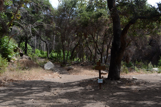
I make my way carefully down to the old oak at the bottom of the trail. The sign nailed to it is a blackened, small shadow of itself, no longer suitable for pointing the way anywhere. The tree is black too, but bursting forth with green once more. I head the short way further down to meet my trail up, then back to the car.
©2018 Valerie Norton
Posted 4 October 2018
Liked this? Interesting? Click the three bars at the top left for the menu to read more or subscribe!


Comments