Posts

Showing posts with the label Imperial County

geoglyphs

Image
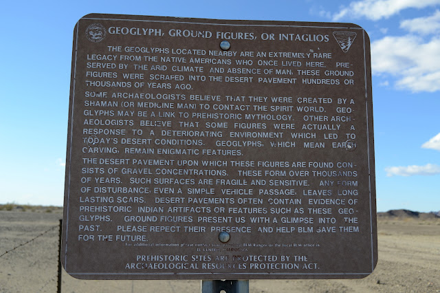
Yuma BLM I noticed a pair of mysterious fences near the road while traveling back from one of my hikes. I stopped to read the sign of the nearest, which provided an explanation, and have returned today to actually see what they encompass. That most ephemeral and uncertain bit of ancient art: the geoglyph. And past the sign, narrow and long within the fence boundaries, is the preserved geoglyph. I rather suspect that without the sign, the fence would have been cut by now. As advertised, there are lines where the rocks have been removed from the generally flat and rock strewn surface of the plain. The first geoglyph from end to end.

Pilot Knob

Image
El Centro BLM Click for map. Today I aim to add another Pilot Knob to my list. It just feels right to do. This one isn't very big, so shouldn't take very long, at least if I do it directly without any extras. It has a benchmark, but off on another peak to the west. There seems to be a bit of that going around. And then I may as well grab the geocaches. They look to be generally on a path going up to West Pilot (the benchmark), then Pilot Knob, then down again. I drive in directly and grab a bit of "parking" in a convenient spot between the road and a sign forbidding vehicles behind it. That leaves some flat desert with minor washes to cross between me and the peak. I gather the usual way to go would be to jog over to the east where there is a quarry and park there, but this looks at least as good to me and doesn't involve being in a quarry. Pilot Knob and West Pilot. West Pilot (on the right) seems pretty big too. I spot numerous trails up as I wal...

Algodones Dunes

Image
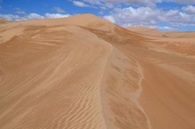
El Centro BLM Click for map. When I first looked southwest from a high point in the Cargo Muchacho Mountains, it seemed that Mexico was somehow demarcated in a different color by nature. Of course the color line had to actually be something else and the border doesn't quite run right there. Turns out the something else is sand dunes. These aren't just any sand dunes either. The Algodones Dunes, also known as the Imperial Dunes, are famous on stage and screen. Well, maybe just screen. These dunes "played" Tatooine in Star Wars. And I thought I might see them on a weekday, but it is already Friday (morning) and they are an absolute mad house. A quad and a bike take off across the sand over the well established tracks. The road in has frequent pit toilets and is lined with campers and toy haulers all presumably with permits. The dunes have a low area that is a veritable highway of tracks to get out into it all and high areas where people play. The hi...

Tumco and the Cargo Muchacho Mountains high point

Image
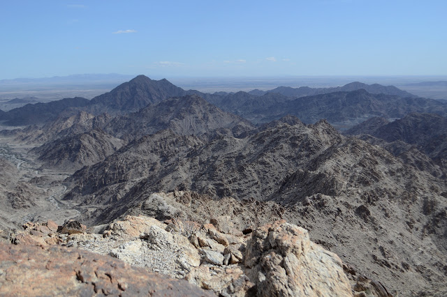
El Centro BLM Click for map. (Purple and orange lines.) I am back for another try at the Tumco benchmark and the high point of the Cargo Muchacho Mountains. This time, there will be no wishy-washy moments where I think one bit of plan is as good as another and just go for the one that involves the climbing right in front of me. There will be self discipline and I will stick to the plan. Also, I have stacked the deck and chosen a route that I think will not include any temptation to leave the plan. I am going to follow the reach published for the Tumco benchmark, or at least my best interpretation of it, and then follow the ridge on up to the high point. The azimuth can happen in between if I am feeling it at the moment. The way down can be either back the way I came or over the top, again depending on how I feel. Okay, so there are choices in there, but they come when I have solid information about what will be the one I'll like best. This time I am starting at the parking...

Cargo Muchacho Mountains - attempt

Image
El Centro BLM Click for map. (Green and blue lines for this one.) After Stud Mountain , the other peak marked with a "1k" on its dot on the peakbagger map among the Cargo Muchacho Mountains is the unnamed high point. Well, surely I should visit the high point of this little range. For some reason, the surveyors have not seen fit to. They instead have placed a mark called Tumco (for the mine below) on the second highest point of the ridge a bit west of the peak. They placed their azimuth point on a peak even further west. That makes two more peaks I'd like to climb. The peakbaggers who have gone before (and offered any hint to their route) speak highly of popping over a pass with a mine high up it, then over a few more short passes on the far side before taking a wash up to the ridge between the high point and Tumco. The first fellow actually scrambled along the ridge first, possibly hitting the azimuth and traversing around the benchmark peak before climbing to ...

Pasadena Peak and Stud Mountain

Image
El Centro Field Office BLM Click for map. Two days ago was Pasadena Mountain, now on to Pasadena Peak. The peak is really just a warm up for the main bump of the day, Stud Mountain, but I have a feeling one had better get this peak before it gets flattened by mining concerns. This is one of two peaks in the Cargo Muchacho Mountains with 1000 foot prominence. The peakbagger web site helpfully marks their dots with a little "1k" to say, "This one sticks up a bit from its surroundings." I am using roads from the American Girl Wash for my approach to Pasadena Peak. They get me up the side pretty far, then I'll just have to wing it. To go up Stud Mountain, I am using a wash on the Pasadena Peak side, then will head down along a route people have posted on peakbagger using the north ridge back to a flat area that can drop into the top of American Girl Wash with only a few feet of climbing. I had actually wanted to start in the old town of Obregon, but for my...

Pasadena Mountain

Image
El Centro Field Office, BLM Click for map. Now on to the main hike of the day: Pasadena Mountain. I know there's a trail up a lot of it because there's a geocache rather high up that claims to be the end of "the mystery trail". It doesn't say where the trail begins, though. I expect to try coming down it, but for up I'm trying a route I am calling "long and easy". How true that last bit is remains to be seen, but it looks to have a gentle climb. How wise it is to be using a "long" route when I only have a little over 4 hours to sunset also remains to be seen. A summary of "long and easy" is as follows: First I get myself to the north end of the mountain where even the USGS map, which seems reluctant to call anything around here a 4WD road says I better have that. From there, take a right into a large wash and just follow it up in a gentle climb until I've just slightly overshot the peak. Then turn left where there is...

Ogliby Hills

Image
El Centro Field Office, BLM Click for map. I thought I'd do something small before going on to something medium. I picked out a line during the drive up, but probably won't get to do it because I also picked out a couple geocaches to find. One is a multicache that I'm sort of hoping will just lead me along a route up. It seems like a sensible thing to do with a multicache to me, anyway. First, to grab a somewhat random parking spot. A 4WD vehicle can get closer, but there's not a lot of point. The appetizer. There's a bit of flat stuff between here and Ogilby Hills, but it isn't as long as it looks. Pasadena Mountain will be the main course later. So I head over toward the hills aiming at the first geocache which is a traditional one on a little outcrop that isn't part of my quickly and roughly plotted route at all, but I knew that would happen. Hiking to it is rough, but not hard. It's a spot overlooking the road, so of course I us...