Posts

Showing posts with the label campgrounds

Ruth Lake and Jewel Lake
Image
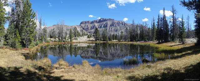
Uinta-Wasatch-Cache National Forest ( map link ) Parking at the trailhead for Ruth Lake requires a permit as part of the Mirror Lake Highway Recreation Corridor (UT-150). It even had a fee tube with a note that Saturday was a fee free day even if I ended up charged for it. (Grrr!) The trail rises its way from the highway to Ruth Lake in 1 mile, then continues upward to connect to Lofty Lake Loop on the ridge above. I had plans to visit Ruth and a few more lakes which have use trails visiting them. Where to start for Ruth Lake A little water makes a little waterfall There's a couple generic ecology signs along the way to make it an interpretive trail. Trees make oxygen, animals live here. If you take in such things often, you'll learn nothing new. Pooling water in a meadow along the way There's an old junction early on. I got to wondering where it might have gone once, but didn't get to exploring. There's plenty other space I was already planning ...
Dry Lagoon and Stone Lagoon, California Coastal Trail explorations

Image
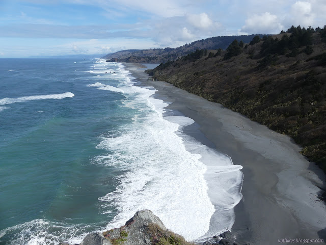
Humboldt Lagoons State Park Click for map. I was thinking I might try to write up a guide to hiking the California Coastal Trail through the Redwood National and State Parks, where quite a lot of it actually is trail. Then I reflected how much better I knew the southern parts of that especially as I found out there's a little trail before getting to Crescent City north of the Last Chance Section. Then I realized that there are parks nearby to the south of the redwood ones and... where does it go there? It only gets the briefest thought on the Patrick's Point State Park map , out on Agate Beach. It is actually marked on the Humboldt Lagoon State Park map , but with holes. Mostly it follows along the sand spits that wall off the lagoons from the ocean. There is one bit of proper trail to get around Sharp Point that I have actually hiked before, albeit in a hurried fashion . The north end of that is one of the holes. I already knew that was real for official trail. There a...

Cozy Dell to Valley View Camp

Image
Los Padres National Forest Click for map. I've been thinking I should go back to Cozy Dell for years now, then Thomas came roaring through, but I still kept thinking it. Thomas is a fire, of course. It stayed California's biggest for 6 whole months. That was just over two years ago and the forest was open again before it was officially out. Bernard's somehow never been on this trail, so he wanted to come along. It's not that he's never noticed it when passing along on CA-33 to somewhere further by a little or a lot, just that he's never stopped to see where it goes. There's a bit of potential for exploration, but I only plan to take the official trails to check on Valley View Camp. If I lived in Ojai, I would know all the little tracks up here and have got myself to Nordhoff Peak by a half dozen different routes including some from here, I expect. I've done it by a quarter dozen others anyway. The trail is well signed at the highway and ther...

Grasshopper Mountain and Johnson Camp Loop

Image
Humboldt Redwoods State Park Click for map in new tab. I was wanting to do some redwoods "properly" meaning, well, wander beneath them for a while trying to look up far enough to see the top. Probably. I'm not really sure. But redwoods. Properly. I noticed I could find some and get a peak as well and went for it. I also noted that it is a bit of a long hike and I would want to use all the light of this short day and started off very early. The route up the mountain starts with a fire road signed as "lookout". The main parking at the bottom of the road is all signed no parking from sunset to 8 AM making it illegal for another 1.5 hours and I don't want the pressure of getting down before sunset (after all, there is still some light available after sunset) so continued on to something unsigned next to the gate. It is still quite dark as I park and a little lighter once my shoes are on, but still too dark for the camera to autofocus on the gate for a ...

Sisar Canyon and Horn Canyon

Image
Los Padres National Forest Click for map. I actually took the time to ask if someone else wanted to hike and when the dust settled, we were three strong and had a shuttle hike going up Sisar Canyon (which Matt wanted to do) and down Horn Canyon (which I was more keen about) doing maintenance on all the geocaches along the way. The hike up is via road which makes for a very gentle climb, at least by our standards, nearly up to the top of the hills (AKA mountains) behind Ojai. Parking has changed at Sisar since I was last there . Previously, there was a nice lot after a not particularly nice bit of dirt road, but now the road has a gate because people wouldn't quit treating the adjacent private property like it was public property, and in rather abusive ways at that. Now they have ruined it for us all and there is much less parking further back. We left a car at the bottom of Horn, which has not changed much , then got around to Sisar in time to claim one of the few spots....

Sisquoc River trail work

Image
Los Padres National Forest Click for map. This is another bit of volunteer trail work hosted and organized by the Los Padres Forest Association . It is a little longer with groups coming in Friday morning or Saturday morning, all leaving on the holiday Monday except one hiking out earlier. Food and BEvERages are provided with a dedicated cook for the preparation. Since we can drive in, it can be quite elaborate. I opted to come in on Friday. Friday We gather at the Lower Manzana Trailhead at 8AM. From here, there is the option of hiking in while others carry any gear and a few people take that opportunity. At least one is even going to try out Hurricane Deck for their route in. The rest of us collect into a reduced number of high clearance 4x4 vehicles to travel the private road that accesses the ranches near the Manzana Schoolhouse. This is something quite new to us since in general the public has no access, not on foot and especially not on bike, to this road. It is rou...

Forbush Canyon trail work

Image
Los Padres National Forest Click for map. This volunteer trail work trip was actually advertised as in Blue Canyon, around who's edges the Thomas Fire lapped its greedy tongues but ultimately left. That may come, but for now we are actually along (north) Cold Spring and Forbush. Workers could go in Friday night or Saturday morning and I chose the morning. We work Saturday, mostly, and come out Sunday. The roads along the edges of the burn are closed, so we gathered at the road block at the top of Gibraltar Road to drive in along Camino Cielo to Cold Spring Saddle, then gather up tools and take off into the green side of things. Saturday But first a look at the burn scar to the south. It was astonishing in its completeness over some areas as we drove in. Other areas were mysteriously left. The high part of Cold Spring Trail as it reaches the saddle from the south. Montecito Peak has been scoured by the flame. Loaded down with a few tools and our overnight gear,...

Lower Manzana trail work

Image
Los Padres National Forest Click for map. The Los Padres Forest Association has a double header of trail work with camping at NIRA in between and I decided to join in on the fun. There is even tree felling promised for today, but I am in a group that will hike down a few more miles and clean up some tread. Better luck next time. We get to see a lot of the trail, but might miss big trees coming down. We collect some tools and head off for it. Getting on down the trail. There are five workers across the way on the trail. A little over a mile down is Potrero Camp, which is currently made dangerous by standing dead pine trees. Some gather to make it safe.

Lost Valley trail work

Image
Los Padres National Forest Click for map. The Los Padres Forest Association has a double header of trail work with camping at NIRA in between and I decided to join in on the fun. There is even tree felling promised for the second day, which I have not yet witnessed. Today is just ordinary sawyer work on downed trees in Lost Valley. Safety gear, safety talk, a gathering of equipment and tools, and we set off up the Manzana to Lost Valley. Everyone here today has done this before and it does not take very long to start. Heading up the Manzana in the morning sun. And up along the Manzana Creek, but high enough above to generally not see it. The junction is still hidden up a hill and probably will continue to be for the foreseeable future. Still, someone did manage to accidentally find it once. I wonder how that happened. Maybe got into camp, which is practically on the trail, and decided that was the wrong way then looked around for where it did go. It seems a plausible...

Matias Trail

Image
Los Padres National Forest Link to map. The trail just wanders through some beautiful country and an approximate plan was hatched quite some time ago to see it. Putting the finishing touches on it, I dropped off my bike at the crest of the road by La Cumbre Peak and parked the car at the top of Arroyo Burro. The bike will take care of most of the paved road walking very well and extraordinarily easily. The Glass Factory is already booming with a large variety of explosions from five or six groups of target shooters. Slow and measured or fast and finishing off a clip, there are all kinds of shooters. About two people notice me as I walk past behind them with my fingers in my ears against the sometimes painful level of noise. Happily, no one is set up on the road or up the hill next to it. There is relative calm past the gate and around the hill as the view quickly opens up. Being up high sure is good for views. A view dominated by Little Pine Mountain with some taller...

Redrock Mountain

Image
Angeles National Forest Link to map. Redrock Mountain really catches the eye when viewed from the west side where its deep red heart is on display. Since I have plodded along on a few trails that do this, the mountain has eaten into my consciousness. The area around it was once quite popular among hikers and each excursion I have done around its base has shown me new reasons why. Today, any entry into the area requires first a mile along paved roadway before getting to a trail that can get one to the good stuff. It tends to weed out anyone who is not looking for a long hike. Today, I am looking for a long hike. I will head up Fish Canyon and climb that mountain, then return via Redrock Canyon and (Old) Telephone Road. A previous excursion that returned via Telephone Road lead to a bit of disappointment in being only able to see some of the beauty around me because it was already getting dark. Timing for off trail travel is uncertain, so I could end up in the same situa...

Potrero John

Image
Los Padres National Forest Just enough time for some real hiking in the form of an afternoon hike out to the first waterfall in Potrero John. Hopefully. With a couple pauses, we launch ourselves into the narrow canyon that starts off the hike. The crossings are not running very high and there are bits of frozen ground rather than mud still. There is a little mud, too, but there are ways around it. The initial opening into the canyon of Potrero John Creek. One shinny new wilderness sign to mark the boundary of the Sespe Wilderness. A little bit of icy snow remaining in the more northern portions of the narrow canyon. The canyon opens up again just after we have some difficulty getting over some trail that seems in great need of work with a bunch of trees stretching across it. When I did this one cool morning, there was a stark difference in the temperature as the canyon widens. This afternoon, there is no distinct delineation. It is an odd sensation of a m...