Cozy Dell to Valley View Camp
Los Padres National Forest
Click for map.
I've been thinking I should go back to Cozy Dell for years now, then Thomas came roaring through, but I still kept thinking it. Thomas is a fire, of course. It stayed California's biggest for 6 whole months. That was just over two years ago and the forest was open again before it was officially out. Bernard's somehow never been on this trail, so he wanted to come along. It's not that he's never noticed it when passing along on CA-33 to somewhere further by a little or a lot, just that he's never stopped to see where it goes. There's a bit of potential for exploration, but I only plan to take the official trails to check on Valley View Camp. If I lived in Ojai, I would know all the little tracks up here and have got myself to Nordhoff Peak by a half dozen different routes including some from here, I expect. I've done it by a quarter dozen others anyway.
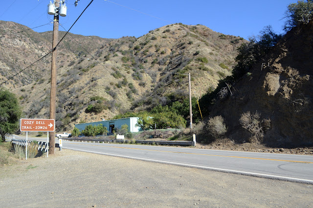
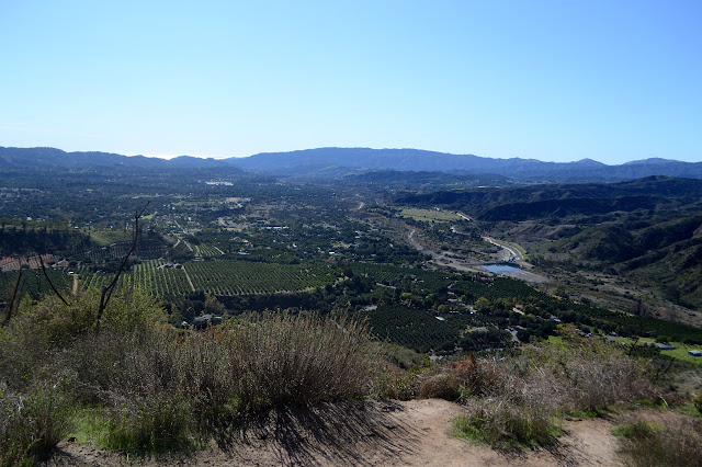
Trail follows up a minor creek, but this is not yet the Cozy Dell. That's just over the hill, so the trail swings back upon itself and starts to climb. It's wide and rutted with water and well used. None of the bad is noticeable to fresh legs as we pay more attention to the orange tree groves. That's the real southern California. People would come here and plant their oranges and do better than those coming to dig out the orangey metal. I don't remember when this was all orange groves, but everywhere for a few hundred miles on down the coast and much of inland has a time when it was. We also ponder the trail up the far mountain. I think I remember it being there before, curiously well used then too, but then memory has a way of claiming what you want to hear.

The trail dips and climbs on its way east above the Cozy Dell. There are houses down there somewhere, not that we really see them. Tracks break off to climb the hill. If they join up and follow the lines of the map labeled "Dozerline Trail", they make a fast way to the road at the top. Those are yet more routes to Nordhoff Peak. We're not going that far today. I still plan to see the camp and wander back, but there are two ways about it. We wander up and down with the official trail.

We head down to meet Cozy Dell Road below, crossing the little eternal stream that must be spring fed because there's almost no basin behind it, crossing the huge dry creek bed that must have been something awful when the rains yet just after the fire. I want to take Foothill Trail instead of the road, so when it splits off, that's the way we go.


As we come into view of Pratt Road, Bernard announces that he has been on part of this trail after all. He came down off Nordhoff Peak this way one time. Some people got lost trying to make the way back to Gridley Road and took it personally. Well, back to a place where they managed to get lucky and get a spot of very few over to the east rather than a name, but that sounds like Gridley to me. The rest sounds quite plausible too. I couldn't say much about the last bit, although surely it was just one of those mistakes that comes about when the horses start to smell the barn, as they say, after a long walk.

We drop down and cross the creek, flowing rather well at the moment, and climb up to join the road. A single tree offers some shade as we reach it. Looking up the canyon, I don't have much hope for Valley View Camp. It seemed to be a constantly watered place. Even if the water wasn't flowing, there were pools. Now I just see the hard rocks and short scattered brush all the way up to a slightly larger lip of rock that is, if I recall it correctly, the viewpoint of the valley at the bottom of the camp.


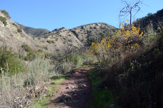
We follow the road until it becomes Pratt Trail, noting that it used to continue to be road further up. Eventually the bed beneath the trail is as narrow as the trail with no hint as to if the old road took another route, stopped, or just couldn't stay on the hill side the trail now passes along. It is quite steep and sun baked, especially now after Thomas roared.


As we get close, there is a hill that seems greener all over. As we can see up the tributary where the camp rest, it looks like a mixed bag. There are still trees, but there is also change. I will have to get down there to see. If the trail still goes. The top part looks well used, but the bottom looks like it is falling. More mixed impressions.

The spur trail down to the camp does start out solid, but where it crossed a tiny stream once, it now follows that stream a little and them climbs out onto rough trail. Bernard decides to avoid the poison oak and turn back. He's probably right. Those bare sticks there look very suspicious and that one reaching across the trail especially so. I hope pushing it aside doesn't leave me with enough oil to get it. I still have to see the camp. It's only a few feet further to the metal ring left for campfires. The fire definitely came through, but the trees are here although some have become little bushes regrowing from the roots. A lot has had to regrow.


Having looked around, I head back up and around the trail that feels so much on the edge to a sunny spot where Bernard is having the rest of his lunch. I had demanded some lunch as we were above Pratt because I am a slave of my demanding stomach, especially when it shouts.

Then we head back down to the road and turn right for the shorter way back. The shadows are already starting to get long as we walk along Cozy Dell Road. None of my maps shows the spur up into the little peak to the left, so that gets a comment before we return to following the creek. The way out follows the creek until the trail starts again.

Everything is golden as we follow the creek. The leaves aren't many, but they dangle like golden earrings. The hill sides are touched with golden light that from this angle just goes around the edge. It is a perfect moment in the Cozy Dell.

The trail does not hide, and we turn to follow it easily. The stream still bubbles as we head up and along, wobbling up and down, then down. Now the ruts of water damage elicit notice. Was it this bad when we started? It's not like it could have developed on a perfectly dry day. Tired legs notice all the difficulties.
©2019,2020 Valerie Norton
Written 24 Jan 2020
Liked this? Interesting? Click the three bars at the top left for the menu to read more or subscribe!


Comments