Iaqua Buttes Lookout
(almost to) Arcata Field Office BLM
(map link)
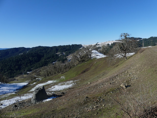
I looked around the Kneeland area and concluded the Iaqua Buttes Lookout at the top of the highest of the Iaqua Buttes would be a nice place to go and a little over a day after a passing storm dropping a couple inches of snow down to 1000 feet might be a particularly picturesque time to do it. Well, assuming roads weren't too treacherous. The car managed to climb up one icy piece of road just fine, but wouldn't turn right to follow the curve of the road and stay out of the oncoming lane, so there was some treachery going on. I found a beautiful big parking area on the side of Kneeland Road just short of unsigned Slater Road to make my start.
Within 5 minutes, someone had stopped by to make sure I was okay (something that happens with disturbing frequency) and then informed me that this trip would be a failure. That county road goes up a little way and stops at a locked gate long before arriving at the patch of public land around the lookout. Sure the road keeps on going, but there's no right of way. Those are so called "landlocked" public lands over there. But nice day for a drive. He then went off up the hill a short way and passed by again having somehow acquired a third dog.
Having got here and parked, I was going to do what I could of my planned hike. Besides, I wanted to give the road maximum time to melt out on this cool, but decidedly above freezing, day. I quickly passed a "private property, no trespassing" sign set to discourage the public from using the public road.


Tree workers had been out on Kneeland Road and one set passed to park just ahead of me. I later heard them chipping the nearby small pile of wood. They were too far off to hear them turn around and head off to the next spot of work.


Over the top of the hill, I caught my first sight of the Iaqua Buttes Lookout. A state forestry ranger was stationed there for the 1928 fire season with good success, so they built the lookout shortly after. A telephone line was run to a local ranch where Mrs. Francis Slater was in charge of getting all the calls that came from this lookout and all of Trinity Forest (for it wasn't Six Rivers yet) behind it directed for Eureka. Apparently Francis and Hugh Slater were "lookout attendants" here for at least 20 years, while others were the actual lookouts. So now we know who Slater was.

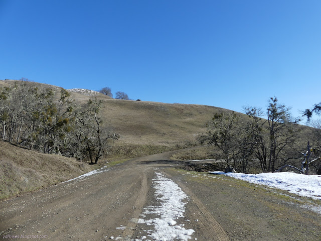
Shortly after topping the hill, the road splits at a Y. A small sign sits between the split up against the left side states that this is private road. Maintenance certainly goes to the left. The snow was perfectly smooth covering the left while right had remnants of weeds sticking out the middle. Right is the way I wanted to go and the way the map claimed Slater continues. Unfortunately it quickly arrives at a set of gates. The first was unlocked with a locked pedestrian gate at the side. The second was just locked.

I guess I should have checked Peakbagger prior to going. There was one single attempt by Bob Burd. He decided he had come too far to turn back when he encountered this locked gate and successfully bagged the peak without causing disturbance or being disturbed. He speculated the land and gate were part of the "Iaqua Ranch/Reservation". I assume he means the Iaqua Ranch property on which the Northcoast Regional Land Trust secured a conservation easement. This is part of their Six Rivers to the Sea project. It sounds like quite a trail, especially when standing out here in these particularly open hills on a not so hot day. I think I'd be figuring out when I can go if there was such a trail. There isn't and won't be. The NRLT is strongly about sustainability and not about public access. Six Rivers to the Sea is a project to conserve a corridor of wilder lands. The ranch is required to use sustainable practices while continuing to graze cattle and perhaps cut timber. They may never subdivide and develop it. This doesn't come with any public right to roam or anything. Besides, I suspect this isn't the property.
So I paced up and down the hill a few times. It is only clear that they don't want me parking in front of their gate, which is quite alright by me. But I didn't invest $10 in gas meaning to just look across to the lookout almost a mile away. I wanted the views! And to checkout the lookout itself! And to bag the peak! I probably had about ⅓ of the views I would have at the top and even that would be better from the lookout. I hadn't even gone 2 miles yet. But I did turn back.


I expected 4.5 miles to get to the lookout. With the pacing, I'd only managed 4 miles total. A truck with a plow on the front and a fancy crest on the side head up Slater Road as I grabbed a snack before leaving. Yep, the county maintains it. I stopped a few miles down the road to get a little of the ocean views I missed out on by not going up the lookout.


I dug around a bit after to find that the county maintains 2.35 miles of Slater Road from Kneeland to road #2136, whatever that might be. I probably have to call someone to get a scan of map 02D to find out. I didn't walk as far as that, but perhaps the county measures lengths to ±25% accuracy. The National Map reports that Slater ends at the Y. Tend left for Flying W Ranch and right for Iaqua Lookout Road. Iaqua Lookout Road is not on the county's list of roads. The unnamed roads heading off west of it and accessing a big chunk of public land that wanders over to Gordon Ridge, which I was also interested in, is also a no go. It looks like those really are landlocked public lands. Although... maybe the lookout road is state?
I'm trying really hard to focus on how it truly was a perfect day to be out in the hills, in an area I've never been before. The thing is, I really wanted to be there at the top.
*Humboldt album*
©2023 Valerie Norton
Written 19 Feb 2023
Liked this? Interesting? Click the three bars at the top left for the menu to read more or subscribe!


Comments
I think it's marked as a "local road" rather than a "private road" by the legend, but the distinction could be clearer. The county's road numbers are only a few years old (I think?) and maybe this is an old road number? Would they forget to renumber a road? It would make sense that the state's obligation for upkeep for that road is to the county. I see it's marked gated further down, but not in this first section.
All I know for certain is that Iaqua Lookout didn't receive any maintenance, no so much as an assessment if it needed maintenance, by the county in 2022 because it's not in the maintenance log.