Jennie Lakes: Belle Canyon and Rowell Meadow
Kings Canyon National Park
Sequoia National Forest
Giant Sequoia National Monument
Click for map.DAY 1 | DAY 2 | DAY 3 | DAY 4
It was another mild night, but the mosquitoes very nearly vanished early on into it. The sun comes quickly here and the morning golden hour is really quite something. I enjoy it with breakfast and happily the mosquitoes seem to be slow to wake up.


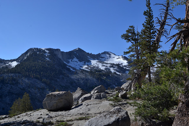
We head out to the trail again and wander gently downward, still high above the valley bottom. The air seems a lot clearer today and the snow on the far mountains is much more defined.


As we start to circle around the uninteresting end of the Ball Dome outcrop, there is the trail to Lost Lake. A half mile up (and down again) and some miles to get. I decide against going although we have not been able to see it from above anywhere along our route. Some backpackers come down after us stating that it is definitely the most beautiful lake they have been to in their lives, so perhaps it was the wrong decision to forgo just half a mile and some climb.


Upon reaching Sugarloaf Creek in Belle Canyon, it is clear that all my fancy footwork to stay to rocks and such above water instead of it in has just run out. The creek makes its lazy way through a meadow and there is nothing for a while in either direction to offer a crossing. The only question is do we stop to take shoes off or just plunge right through. My shoes have dried rather well when I accidentally dipped a toe and it is plenty warm, so I elect to plunge.

Just across the creek is a trail junction and another choice. My original plan was to continue down to Comanche Meadow, then turn north toward Williams Meadow and swing west to Kanawyer Gap. This is all trail on the old 15' map, but has been dropped from the 1993 7.5' Mount Silliman map, so there is some worry about finding it. Harrison does include it. It will also add something like 4 miles to the route, which it is looking like I do not get to do. We turn up Belle Canyon instead.

Shortly after is another junction, this one to go up to Seville Lake. This one has a second trail in that would drop us off almost at the top of the pass we are climbing anyway and is only a half mile extra. I am more enthusiastic to go for this one, but cannot get any interest from Martha. At least we should be able to look over to it sometime on the high up.

This area has had a recent big burn killing off numerous trees and leaving just a few islands living. There are a lot of trees to jump and nowhere that feels safe to stop. The group coming down from Lost Lake had mentioned a lot of trees down going to Comanche Meadow making it quite hard work to walk that trail. Perhaps it is just as well we did not go that way. The rocks behind the burned trees do suggest the canyon is well named.


Eventually, we do get trees again as we climb. We never do get to look out to Seville Lake, so it is another one we do not know at all even after being so close. It certainly looks like a nice spot on the topo. We never see the trail up from it either.

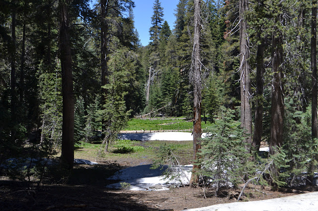
There is not a lot of down to get to Rowell Meadow. Lots of trees and meadows and little streams make for a pretty stroll on the way to the next junction. Wet feet? Maybe a little, but they are already wet now.
The junction at Rowell Meadow has no signs, just posts, but is very clear. The trails are all lined by large trees and cuts for at least 100 feet around it. We turn left for Boulder Creek, leaving behind the last chance to go sprinting up the Jennie Lakes Wilderness high point. The route has some very non-wilderness surprises. First we get an actual bridge over one larger creek, then there is a tall cabin used for snow surveys.


We get no more bridges as we continue toward Boulder Creek, although they would have been appreciated. After the stomping through the 3rd or 4th creek crossing, my shoes have started to feel slushy and it takes them 10 or 20 minutes to quit it.


We have one more little climb before a longer down into Boulder Creek. Signs posted at the start warned that this one could be a little dangerous, so we will probably stop at the creek to wait to cross in the morning, when it should be lower. We actually have four crossings coming up, but my guess is the second one will be the hardest, but also have some flat areas nearby.


There are two little streams along the way, but neither of these are one of the crossings expected. I ponder stopping at the first for water since I seem to have run out and it is hot, but it is not long before we stop and the hill is steep and the trail is just wide enough for my foot. I may as well get to the hoped for flats. I cannot quite see the joined creek below as it rages behind a layer of trees. There is just a vision of white water.

The first of the crossings is a bit large and full of white water, but there is a tree bridge. It is a bit rounded and slanted for confident walking, high above the thrashing water, but free of bark and easy enough to shimmy downhill on using hands to steady. The second crossing does look a little tough and is just after a little used, but quite suitable for us, campsite, so that is where we tuck in for the night, surrounded by the roar of Boulder Creek. There does seem to be an alright crossing spot below the trail for our travels in the morning.

Continue to the next day ⇒
©2017 Valerie Norton
Posted 10 July 2017
Liked this? Interesting? Click the three bars at the top left for the menu to read more or subscribe!


Comments