Winter Backpacking in and around Humboldt
I have only had one single solitary backpacking trip this year and it is not nearly enough. It has me thinking about winter backpacking opportunities in the area. I am specifically thinking about trips that, in a fair weather window, require no special winter equipment, although microspikes might still be a good idea. While you shouldn't need to exercise any special winter skills, the are still important to have. Weather tends to be a bit less predictable and a swollen creek will be more dangerous than one the same size that usually runs high. I'll start with some I have done, one way or another, then move on to trips that are speculation. These do happen to be reasonable summer trips, too.
Keep in mind that while a trail may be low enough and not cross large bodies of water, access may still be a problem for potential backpacking areas. Anything over 3000 feet can have snow that sticks around for a while. Storms can bring snow levels down to 1000 feet and less.
For elevation changes, I categorize a "climb" as on the order of 1000 feet. A "good climb" is more like 3000 feet. A "big climb" would need to break 4000 feet. I have been known to refer to 200 feet as "barely worth noticing". This likely stems from growing up with trails that generally climbed about 3000 feet, but I keep finding that mountains often go about 3000 feet from the low bits to the high bits. Impressive ones go more. Embrace the climb! (Worry about knee health and slipping on the descent.)
Elk Camp Ridge

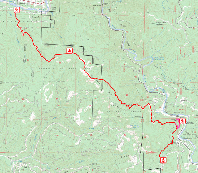
I hiked this one February for a cold, but fairly snow free trip. It is in the north part Six Rivers National Forest in Del Norte County. It follows motorcycle trails and a little bit of road and would have followed more road to complete the loop had I not shied away from crossing the West Fork of Patrick Creek. When I think back to things I crossed later that same year, this crossing looks very simple. I got to bag two peaks, one that was a fire lookout, check out a mining area, and would have had hot springs at camp had I crossed the creek. Instead, I had pine needle tea because I hadn't noted well enough were the last water was on my way down. This goes over 3000 feet and there was patchy snow, so it could be a more winter-like trip if the weather is bad. A loop trip is ~27 miles and only gets halfway to a good climb before rolling along.
South Kelsey Trail

This is another in Six Rivers National Forest in Del Norte County. I hiked this in spring, managing to cross Eightmile Creek, which one should not expect to do in winter. In fact, I shouldn't have expected to cross it in spring. However, one can still hike along the South Fork Smith River to it, where there is a camp that should not be used if flooding is possible. Just short of the crossing, trail makes a good climb up ~6 miles to the remains of an old fire lookout and its view. Popular trips are to hike in just 2 miles to the shelter at Buck Creek or hike in to somewhere around Eightmile (where there's a nice swimming hole, but maybe not for winter) at ~4.5 miles. There is some uphill on the way out, but very little climbing if not going up to the lookout, which should be included on popular trips. In my opinion.
It's possible to have a much shorter trip to the Summit Valley Lookout with camping options on the way, but snow is much more likely to be a problem.
California Coastal Trail: Last Chance and DeMartin and Klamath
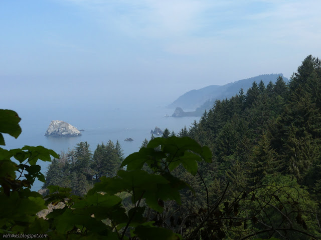
These are along the coast at the southern end of Del Norte County. I've only hiked Last Chance and DeMartin and Klamath as day hikes. This nearly continuous section of trail does cross US-101 twice and has short (1/4 mile) road walk sections on either side of Wilson Beach. The Redwood National and State Parks only allow camping in designated sites, even backpackers, but they provide bear boxes at the sites. Yes, bears can be active in winter. You need to get a free permit either from a visitor center or online prior to setting off. Dispersed camping can be had on the gravel bars of Redwood Creek, but since that isn't anywhere near, DeMartin will have to do. Starting from Enderts Beach (warning: the first half mile of this trail often closes in the wet season, so this may not be possible) would make it a ~13 mile hike in. Starting from the Klamath Overlook would be more like 8 miles. From the groves just north of camp is ~4 miles and from Wilson Beach is ~3 miles. From the correct turnout, it's only ~0.5 miles on the service road. Get the camp for 2 nights and start at the overlook, then day hike Damnation Creek (still with the lower bridge off limits) in the middle for ~26 miles with a climb on a couple days. In the wet season, there should be water within half a mile of camp to the south, although there might not be much.
Another option from the same reservation system is Flint Ridge, a little further south, which has a dry camp ~5 miles from one end or ~0.25 mile from the other for a very short trip indeed.
Prairie Creek Redwoods State Park
At the north end of Humboldt County, this is one of those "Redwood National and State Parks" and has all kinds of trails that might be hiked, but camping is only near the visitor center or at Gold Bluffs Beach while parking is only in the backpackers parking lot. You could get more flexible starting points by using the Redwood Coast Transit Route 20 bus, which travels along Newton Drury. You need a free permit from the visitor center or online plus a camping fee paid when you get there. A typical trip is just to follow Miners Ridge to Gold Bluffs, ~6 miles and a climb. Follow the West Ridge for a much longer route, ~12 miles, but not much more climbing.
Redwood Creek

This is in the southern part of Redwood National Park, near Orick. When the creek is low enough, which it can be in winter, you can camp on the gravel bars and cross it rather freely. I did this two out of three nights when I backpacked the area. However, assuming the creek is too high, as is likely in winter, then Elam Camp and 44 Camp are the only options for overnight stays. (Free permits from the visitor center or online required.) These are both on the west side of the creek while the usual entry points are on the east. The only entry available may be the Orick Horse Trails. I've got this idea that it would be dandy to one day walk out the door, down to the main transit station, catch the Redwood Coast Transit Route 20 and get off at the visitor center or park headquarters, then head out backpacking without ever getting in the car. There's more than one route, but Elam is ~7.5 miles in and 44 Camp is ~13 miles. My bus supported trip would probably start at the park headquarters, take two nights at Elam to have a day hiking a loop out to 44 Camp (which seems to be closed at the moment) and back, then hiking out all the way to the visitor center via the levee for ~35 miles with a climb each day.
Lacks Creek

This is that singular backpacking trip I took this year. It is only 40 miles from Arcata, located off Redwood Valley, which is off CA-299. Although it is a Bureau of Land Management property, they do require all campers, even backpackers, to stay in designated sites. Many of the sites didn't thrill me, frankly, but the sites on the Beaver Ridge Prairie and Flyette Prairie both look a little nice. The one at the spring where the main trail first splits and the one at the south end at the top of Beaver Ridge have a little going for them, too. Campfires must be in the provided rings but they have only been provided at the trailhead so far. This de facto bans campfires. The area and the road in gets slightly above 3000 feet and might get snow. Trips could be 4-25 miles without all that much climbing.
South Fork (lower Trinity)

This a few miles off CA-299 in Six Rivers National Forest, just over the county line in Trinity County. I day hiked it to the river ford, which is as far as you can get now that the bridge is out. Pass the horse trail to the ford and the old footings for the washed out bridge and there are a few campsites with only mildly challenging access to the water. Hells Half-Acre Creek could get dangerous in storm surge. It's ~4 miles with a little climbing, more rolling, on the way.
Wooley Creek

Just outside Humboldt in Siskiyou County and Klamath National Forest, this trail follows Wooley Creek, often quite high up the edge. I did it a couple of times, but when I might be able to go again is a question as the McCash Fire just burned part of it. (The area is currently under a closure order and the state of it and its amenities is uncertain.) Popular trips include ~3 miles in to Deer Lick Creek (not just burned), where Wooley Creek is accessible, or ~9 miles to Fowler Cabin. Less popular is ~15 miles to North Fork with the easiest camping at Bear Skull Camp ~1 mile before. Almost a climb over all those miles. There are some other well used camps along the way, but North Fork Camp shown on the map is not one of them. You probably won't want to cross North Fork in the winter.
Humboldt Redwoods State Park

Right in the middle of southern Humboldt, the state park has an extensive trail network and five backcountry camps. Fires and dogs are both very explicitly banned, but you could bike-pack if sticking to the multiuse trails. I passed through two of the sites when hiking to Grasshopper Mountain. You register and pay your fee at an open campground, which means a visit to Burlington in the winter. You won't want to enter from there, though, because it would require wading the Eel River. It is often possible to wade Bull Creek (or even use one of the natural redwood bridges near Tall Trees or Rockefeller Grove). Further along Mattole Road are entry points that require no creek crossing. Pay attention to water as some of the camps are dry. It does get high enough to get snow at the top. Trip length is variable, probably around 20 miles, and can get in a good climb.
Lost Coast

This is a world famous trail at the southern end of Humboldt County and you can find dozens of online guides about how to hike it as fast as possible heading only ever south. I'm afraid I tend to look down on people who have done it, but only ever got off the beach for the bypass trails. There's so much more to the Lost Coast than beach! Winter brings dangers of possible high creeks, higher tides, possible storm surge even if you don't see the storm, and severely bad weather when you do see the storm, but it's easier to find water in the backcountry. Plus days are shorter and it's a little bit colder on average. For the northern BLM run part, permits are reserved online for a $6 fee. They usually vanish quite quickly for the good times when they are released on Oct. 1st, but they get released again randomly, especially about a week before. There are only 30 per day in winter months and you've got to get one for each member of the party even if you aren't ever going down to the beach with the crowds. I've done the whole trail in two different loops (looping the north end and looping the south end), both times on permits obtained a few days prior when the weather was halfway predictable. Minimum ~3 miles to get to a campsite. Trips can vary quite a lot in distance with good climbs possible if you get off the beach.
The southern part is Sinkyone Wilderness State Park and tends to stay up off the beach anyway. You pay your entry fees for the days you'll be there and camping fees for the camps you'll use. There are no reservations. My understanding is that dispersed camping is not allowed, just like most other state parks, so this becomes a much more expensive trip than the north end. Well, unless you insist that it's a really beautiful place, but you just can't stand to see it in the other direction and must get a shuttle for that BLM part. There are no shuttles for the Calparks part.
Little Bald Hills
This trail near Crescent City in Del Norte County passes through a quilt of public lands. On the west are Jedediah Smith Redwoods State Park and Redwood National Park lands with an official camp (reserved free online or at a visitor center) and on the east is Six Rivers National Forest. The whole trail is only ~10 miles. The camp is ~3 miles from the west and ~6 miles from the east via Paradise Trail near the east end. There's a climb. Not a good one, but getting there.
South Fork (upper Trinity)

A short way off CA-36 is a National Recreation Trail that follows the South Fork Trinity River for 21 miles (or 18 miles, depending on which part of the Forest Service description you believe) along the edge of the river. The initial bridge is out, so it must be accessed from the west side roads. The trail travels near the river, so camping opportunities should be plenty. There are a number of small trails that access it from higher roads, apparently for easier access to cabins that exist(ed?) along the route. The one that strikes my fancy is the Rough Gulch Trail, which is a good climb over ~5 miles to road near the Horse Ridge Lookout. That spur does have a couple minor details to watch out for on a winter trip: no bridge is indicated for the river crossing as it starts up and the lookout is just over 6000 feet. Another set of trails provide an alternate route just southeast of there. It's so gentle that it doesn't quite manage to rate a whole climb over the 20ish miles. Long trail note: the Bigfoot Trail follows the upper (southern) portion of the trail and then climbs away on the Smoky Creek Trail.
Trinity Alps
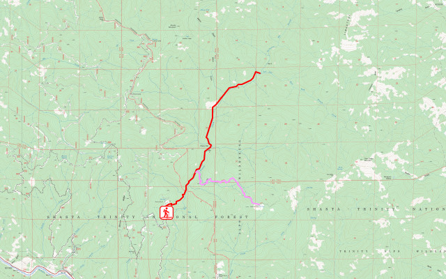
The east side of the alps are generally well covered, but also often quite high up. (There are some posts of early season treks in the area on Jan's Jaunts from spring 2020, like this one at Stuart Fork. You can see even the low trailhead is a bit high for winter.) The west tends to be lower, but less traveled. The New River area has some out and back options with 6-20 miles one way possible. Above shows French Creek (but click the image to see the map with the others). The trouble is, the only thing I can find out about it is it was a mighty fight just to get a mile in 5 years ago. That's more than I can discover about Devils Canyon north of it. New River itself does get some traffic, but those creeks can get big.
road areas
Yep, that's right. Road areas. Roads are a different feeling than trails. It's not just the fact that someone might come driving along them and they tend to be much harder underfoot. The larger cut allows a lot more light in when among trees and there gets to be a layer of growth that hides away the interior of the forest. Trails are, well, much closer to nature and you get to see more things. Still, if you avoid all roads, sometimes you avoid some good stuff. The Cedar Camp area (Klamath) northwest of Orleans could be a good spot. The unpaved roads in this area close in the wet season to protect Port Orford cedar. Perhaps something from near Fish Lake and staying on the graveled banks of Bluff Creek. Perhaps something out to Head Camp. I have of course been looking for but not found the potentially perfect loop. Maybe something north of around Indian Valley (Shasta-Trinity) north of Forest Glen. Perhaps something west of Ruth Lake (Six Rivers).
Liked this? Interesting? Click the three bars at the top left for the menu to read more or subscribe!


Comments
The first part of Somes Mtn. Tr. would be a reasonable choice. Upon starting to traverse the eastern slope of the mountain south, above Somes Cr., the tread gets pretty bad and there are mostly smallish logs to clamber over. Camping should be possible a short distance south along the branching Red Wing Mine Tr., as there are some usually water-bearing ravines and a small pond in that area, and it should be possible to find level spots. That's at an elevation of about 2100 feet, and perhaps four miles in from the trailhead. Climbing very much farther up the main trail, snow is going to become likely and the condition of the trail will soon become extremely bad.
Wooley Cr. Tr.--one you've discussed--would be a very nice choice. If it's been raining, or if there's a thaw up on the peaks, Deer Lick Cr. could be a real problem, so Julia's Camp a little before the creek might be the final destination. The other side creeks at least before Canyon Cr. probably wouldn't be a problem. Probably. (As you know, there are bridges over the big ones--Haypress Cr. and Bridge Cr.) If you go in, check the weather forecast and have confidence that you'll be able to make it back out.
A longer drive up the Klamath River, Clear Cr. Tr. might be a very nice destination. (No Man's Cr. trailhead--I love that name.) But the long dirt road in could have mud or washout issues, depending on the weather. The condition of the road was getting worse last time I was there. Maybe they've graded it since, I don't know.
The McCash Fire closure covering the Marble Mtn. Wild. and adjacent lands was scheduled to expire Nov. 10. I don't see any announcement of any extension of the closure. The closure order has disappeared from the Six Rivers and Klamath N.F. Web sites, which seems like a good sign. The Trinity Alps Wild. closure is scheduled to expire Nov. 15. Again, I see no announcement of any extension. However, the Shasta Trinity N.F. closure order for the Monument Fire and River Complex currently runs through Nov. 30, and affects portions of the wilderness. The Klamath N.F. still has a closure order running through Dec. 31 affecting a few bits of the Trinity Alps Wild., stemming from the 2020 Red Salmon Fire. Crazy! All subject to change without advance notice. (And since they put up few signs, I don't know how people are expected to know all this.)
I couldn't find any BAER report to say what might have happened to the infrastructure up Wooley Creek and one of those bridges smelled so strongly of creosote as I crossed it. Great against rot, not so good against fire. I'm still just wondering. I'm afraid I didn't notice when the fire closure expired and just expected actual burn areas to stay closed for a few months at least. The place where I slapped watercolor into my sketchbook for the picture that is the banner was closed for 9 years after the Station Fire. (Frankly, massively bad decision on their part to keep that closure going for so long.)
Siskiyou Mountain Club is expecting to hit Clear Creek next weekend. The email assures that any car can get up the road. I'd be happy just to get up the part marked improved on the map.
Looks like I was too cursory in looking over that stretch of CA-96 for trails. Just south of Clear Creek, Dillon Creek looks promising with likely camps a little before where it crosses the north fork ~4 mile up.
A little more south, a trail leaves between a pair of bridges and parallels the river for a few miles. Camping on it might leave you listening to the highway at night, but there's another trail that breaks off from it shortly before the end to climb to Ogaromtoc Lake and the primitive campground next to it, ~6 miles. If it's got a table and a toilet, luxury!
The SMC invited me, but I don't think I can make such a big trip. They may be continuing work on the Five and Ten Divide Tr., which looks like yet another buttkicker of a climb.
If that's the rather vertical trail just before Tenmile Creek heading up to, well, the Five and Ten Divide that really ought to have more switchback wiggles, then it would certainly fit with some details. Since Clear Creek is a National Recreation Trail (and Bigfoot Trail), it might not qualify as "long forgotten trail". You're probably right. On the up side, it's probably been mapped really badly.