Posts

Showing posts from August, 2011

sketches

Image
Sketches for the month. The stoves at Little Jimmy Campground . The cabin at the top of Mount Islip . Somewhere up Bear Canyon a ways. The remains of a sea wall past Goleta. Smoke from a dry lightning strike. We watched it get put out from the mountain top . A few bristlecone relatives with very little bark left at the top of the mountain . Roots that come through the rock .

the Grotto

Image
Circle X Ranch Mountain Recreation and Conservation Authority Locate the trailhead. I had read about a trail to a place that was full of funkyness and a good place to go on those hot days as the destination is shady and has pools of water and water flowing around, at least after the rains. The general plan for hot days seemed to be hike down and wait until it is cool while playing on the boulders then hike back up. This was a hot day and I really wanted a hike, but it wouldn't be expected to be flowing very well. I decided to try it out anyway. I had errands to do before hiking, so didn't get started until the middle of the afternoon. I had a bit of an extra drive getting there because the directions missed a turn. Even the gooogle maps directions missed a turn. Something about being on two roads that are actually the same, then a third joins and one of the original roads continues while the other two turn... Anyway, my directions said to be on the one that continu

Mount Baden-Powell

Image
Angeles National Forest Locate the trailhead. Mount Baden-Powell is not the highest peak in the local range. That is Mount San Antonio (Baldy) SSE of it. After that, a few of the peaks around Baldy also top out higher than Baden-Powell, but rising over 9000 feet is sufficient to dwarf the nearby peaks and be generally higher than a lot of people ever get to while being able to freely look around and feel the wind in their hair. The Pacific Crest Trail passes near it and a spur trail finishes the journey to the very top. I took the quickest route, catching the northbound PCT as it travels southward through Vincent Gap. The trail switch backs for nearly 4 miles up the north side of the mountain before continuing on the generally western traverse of the San Gabriels. Over the elevation gain, the trees dwindle from a lush forest full of ponderosa and its usual neighbors to a few limber pine populating the nearly bald top. Vincent Gap is obvious if you know what to look for, but

Rustic Canyon

Image
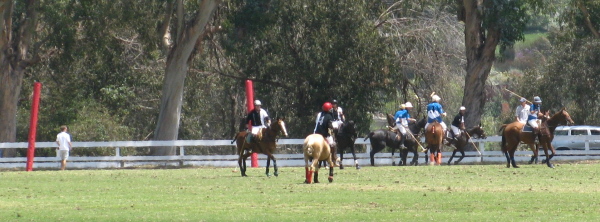
Will Rogers State Historic Park Map the trailhead. It seems it is about time for another Rustic Canyon hike for Hike the Geek. Apparently some people hike down from the road into the canyon and call that the Rustic Canyon hike, but the geeks, or particularly the leader, like the hike I've done before for its variation in terrain type. The hike starts off at the tended green of polo fields, then climbs up to the Backbone trail for a little way before dropping down into the canyon. The canyon starts off wide and lush and narrows into a stony V, but is still rather lush. I got there very early, so sat down by the polo fields where they were actually playing polo. Horses running up and down the field and then at the half, the folks in their summer dresses and wedge heels came out onto the green, champagne in hand, to stomp divots. There was also a contest to find a cork hidden beneath a divot. Someone won and the folks meandered back to the side for the entertainment to

Switzer Falls and Bear Canyon

Image
Angeles National Forest Map the trailhead. I can't say that I miss Switzer in between going there. It is crowded and has a section of trail that is a ledge some 100 feet up a cliff and the stream crossings can get to be a bit much in the wetter times of the year and you can never have the waterfall to yourself. But it does have a bit of variation and is really quite pretty most of the way. I also keep seeing claims that it is even prettier further down the Bear Canyon trail, which goes down Arroyo Seco a little before heading up Bear Canyon to connect Switzer with Lowe. All the times I've been up Switzer, I have not headed up this way. The trail that comes up from the bottom near JPL that I have hiked is the one that joins the trail to Switzer up on the canyon wall. Abbie was saying it was about time to go to Switzer again, so I waited for her to be able to come to go. We looked for a spot at the bottom, but had to settle for a spot halfway down. It turned out we w

Mount Islip

Image
Angeles National Forest Map the trailhead. Not even a full cycle of the moon later, I really did climb up Mt. Islip again, this time by a trail that was quite a bit longer. Since Dan Simpson's writeup of the shortest route describes alternate routes with their vitals, I knew there were actually two routes from Crystal Lake. I thought I might do these as a loop while seeing what this mountain was like in the day time and maybe even stopping by the spring along the way. He also noted (and for this hike the datum was only a week old so likely acurate) that the roads were not open above the visitor center, so the larger lot near the proper trail head was inaccessible. Third, he notes that the ridge route is not on the topo. I grabbed my printed up piece of incomplete information from USGS and headed for the visitor center. I grabbed the last spot in the lot behind it, dodged a batted tennis ball playing at being a cricket ball, and walked in. I asked them where I should par

follow by email