Posts

Showing posts from October, 2015

sketches

Image
Plenty of hikes this month and a few even included sketching. I could find a bunch of horsetails and some water at the spring up Boulder Canyon. Nature taking it back in Solstice Canyon. Hidden mountains along the ridge above Ojai. A deep pool along the Santa Ynez River.

Mt Disappointment, San Gabriel Pk, Mt Markham, and Mt Lowe

Image
Angeles National Forest Following the previous day's peak bagging in the cold, I thought I would go after a somewhat lower cluster of Hundred Peaks Section listed peaks . Parking at Eaton Saddle for the easier access through the tunnel to the peak trails. There is only one other car, but a group of hikers pop out from the trail to Valley Forge and head off around the corner where I want to go. They are still waiting there as I pass by and so on for a little bit of leap frogging. Mount Markham greets everyone as they come around the corner form Eaton Saddle. One of the mountains I am going for, but not the side I will climb. Exiting from the Mueller Tunnel. The Mueller Tunnel is a bit of fun for kids of all ages. At the next saddle, there is a curious bit of animal trail heading toward that steep side of Markham. Here, there are also two trails heading off to the various peaks while the fire road continues slightly downward toward a campground. I am going a

Waterman Mountain and Twin Peaks

Image
Angeles National Forest There are a number of places to start hiking up Waterman Mountain and I chose a more conventional one this time. The day is a dreary grey that I am sure will burn off and I have let the start go a little late waiting for some of that to happen. My previous trip up to the top was an exploration of an abandoned road, and while I managed to put a loop together in the end, it did have a bit of road walking in it. This time, I am starting at a turn out just east of one of the ski resort roads. An unmarked trail climbs the hill a short way and splits, one side heading off east somewhere and one crossing the road to head west. I am going for the west part first, so I take that. Without a lot of ceremony, it delivers me to a second trailhead at the next turnout west, where information boards have been nearly wiped clean by the weather. The well marked trailhead. Sort of. There is no other well used trail from here, but there is a lesser used abandon

Red Rock

Image
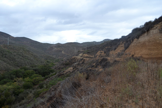
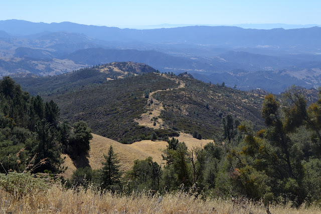
Los Padres National Forest We had a dinner that could not be beat and did not get up until a late in the morning, at least that was the plan. Most people were up only a little late and having a breakfast that could not be beat. Plans to hit a peak in a short hike got scuttled, so we ended up back at the start a little before noon. On the way out, I turned left instead of right and headed to the end of the road because there is just enough time for an afternoon hike looping around the river. There are lots of spots open today, especially by the road. I grab one and start the easy climb. Down below, I can find a bit of trail, but not a lot of river. There is a trail a short way up marked only with who is allowed on it. This would shortcut part of the road, I think, but I stick to the road. The climb is easy and there are lots of places to look out over the river bed. Sometimes, I can even see a bit of water down there. A bit of the complex beside the dam is visible

Madulce Trail

Image
Los Padres National Forest Madulce Trail needs some trees cut out and I decided to get in on the action. We could go in Friday morning and get in two days of work or Friday afternoon and get in just one and I chose to go all in. If my arms did not hold up all the way to the second day, there would be new arms to take my place anyway. The work was originally scheduled for the previous week, but was moved for fear of rain. The rest of us thought Mike was being a wimp at the time, but the changes in the road from that weekend show he was extremely justified in changing the date. Unfortunately, it did thin out the workforce a little. 23 Oct 2015 We arrive at Upper Oso a bit early, for the most part, and wait for our escort through the gate. The first part of the road is an OHV route, but we get to drive it in vehicles wider than 54 inches. A lot of these are the same people I saw coming out as I went up to 19 Oaks and they are quite impressed at the changes in the road afte

Gridley and Pratt Trails

Image
Los Padres National Forest Valley View Preserve For today's brief suggestion of the Fall season that should be upon us, I decided to do a big loop up to "The Tower" via Gridley and Pratt. I have done it in the opposite direction before, but you see different things when you turn around, so that is what I am doing. Parking is easier at Shelf Road, so I grab a spot there before hiking up the road to the trailhead for Gridley. The chill of night should still be on the air, but it is already very comfortable even when not moving. The two spots by it sit empty under the steadily brightening sky. The sign at the bottom of Gridley Trail which is just before the end of public access on Gridley Road. The trail climbs through chaparral at first, then along avocado trees. This section is through private property and sometimes there are people on ATVs traveling along the trees. Today there is one, but he is quickly gone again with the stink following more slowly.

Arrowhead Island

Image
Lake Cachuma Recreation Area With the drought, Arrowhead Island has been abandoned by the lake for a couple years now. It is just an unremarkable hill the highway used to pass by that becomes noticed now because of the happenstance of where a dam was placed. My mother said, "Let's go after Pluto," and so we went. Pluto is a geocache that is part of a set that make up a scale model of the solar system with the Westmont Observatory as the sun. It was still a planet when the model was made and it happens to be on the island. We start at the stub of highway left at the side of 150, which is a little difficult to achieve, then just follow it out. It is bushy at first, but then we hit the high water line and travel becomes easy. Freshwater clam shells are steady company from a few feet down. The old highway stretches away into the lake bed and the island rises to the right of it. The area is vast and flat, but we are about as far from the dam as we can be and

Upper Solstice Canyon

Image
Malibu Creek State Park Santa Monica Mountains National Recreation Area After hiking around the lower canyon, it is a good time to head up to the end of the road to hike around the upper canyon. Really, I only want to do a little loop in the canyon itself, then take off along the one trail here that I have not really hiked on, the Backbone to the east. The parking lot is nearly empty today, but there are a couple young women looking for "Jim Morrison's cave" with instructions from Yelp, of all things. My prejudices show as my mind instantly suspects it is a place covered in graffiti and trash. The only help I can offer is that they are on the only trail going southwest from here, so that is probably where they want to start their search. I turn up the motorway instead and climb to the saddle at the top to look out over the valley. Poking up to the view at the top. Catalina Island in the mist.

Lower Solstice Canyon

Image
Santa Monica Mountains National Recreation Area I wanted to poke along in the Malibu area again and decided to put together a hike with Hike the Geek . The LA group have not gotten together in a while, so I did not expect much. The planned day rolls around with only two sign ups as "I'll try", so expectations are fulfilled. After a suitable wait, neither has shown up. The day is hot as promised, so I start off in the canyon. The weather man promised heat today and it is already quite hot enough, but the canyon is cool. A glimpse down at a clear spot shows a very little bit of water making its way along the creek bed. Trees provide frequent shade along the old road that serves as a trail up Solstice Canyon. Arriving at the house ruins at the end of the road. A little bit of the creek is diverted across the road.

Boulder Canyon

Image
Los Padres National Forest I keep meaning to go up Boulder Trail and see McGuire Spring. It looks like today is the day, although it does seem to be a poor time to go checking out springs as many of them have dried out. Parking is easy enough to find, just pull into the Ozena Fire Station and there is a little lot on the right, beside a kiosk. The trail is a little harder. The kiosk is for OHV activity, none of which is marked near here, and does not mark the trail for self powered travelers. There is no sign anywhere else to mark the trail, either. I head for the well manicured perimeter trail to the south across an empty field and hope that is it. Numerous trails come up to it from the area around the fire station, a road crosses it to get to the local weather station, and finally it vanishes into an area that looks like a removed campground. A people sized gate on the far side is the only indication of where the trail might go. It is not a very confident start as I u

Conejo Canyons

Image
Thousand Oaks The cool is upon us for a day or two before temperatures shoot back up into the 90s. I have decided to join some geocachers to wander the hills of the open space in Thousand Oaks. It does lead to some odd spur trail choices, but also lets me go into new places and tick off that I have been there when I get home. (At least this collection does not fill up the house.) Rain is threatening as we start down the utility road. Starting down into the canyons along the utility roads. We are not going far into the canyons. At the first junction, we turn for a steep climb as the rain starts down. It has already finished as we get to the model plane runway. There are a few fliers out today and they are sweeping the water off as we climb further toward the flag at the peak. Newbury Park stretches out south of the freeway to Boney Mountain. Geocachers (well, one just often hikes with a geocacher) at the flag and taking in the view. (One is conditioning fo

Ranger Peak Trail

Image
Los Padres National Forest The weatherman is spreading a rumor that today may feel ever so slightly like a fall day out on Figueroa Mountain, so I have decided to wander that way and find out if it is true. The wind is brisk and does feel a bit like fall as I get out near the gate on East Pinery Road. The air is still warm enough to need no protection against the wind chill. It would be a great day for the ram air kite I foolishly left in Ruth's truck a couple years ago. I will just have to enjoy the day without that. It is easy because a windy and comfortable day is my favorite type. It is a pleasant stroll to the top of Ranger Peak and its extraordinary view. One small part of the view from a little bit over the peak. I was actually going to take the Ranger Peak Trail, which goes around the bottom and downhill from there. The use trail to the top of the peak goes down the other side. It gets steep as it goes, but eventually joins the trail below. The trail i

follow by email