Posts

Showing posts from December, 2014

sketches

Image
The last sketches of the year. I have nearly finished off this book. Comparing the lush green north facing slope to the burned and sparse south facing slope while heading down Snyder Trail. I found a spot where the power lines still hang (sort of) on the way down Tunnel after climbing Cathedral. Before climbing back up a random fuel break , took a moment to take in the ocean. Before finishing the climb up Fremont Ridge, I took in the low lake and high bridge .

USS Midway

Image
San Diego Sung has been wanting to actually tour the aircraft carrier turned museum down in San Diego and I said sure, so off we go. Of course we start off just attempting to take in the size of the boat. There is something downright comical about the snack bar and tables at the stern and manikin service men eternally hang about on deck. It gets serious quickly going forward. The length of the USS Midway with snack bar at the back.

Scotty's Castle

Image
Death Valley National Park Locate the place. After an unforced error resulted in a an unplanned night on Hunter Mountain and some extreme good luck fixed the problem before lunch, we stopped by Scotty's Castle to find a gas station. Unless the 1920s era tanks are still legal, there is no sign of such a thing anywhere and strong signs the old AAA map is wrong. Still, we are here and it is a very silly place so we cannot exactly leave it again without having a look around. The place seems designed to evoke the idea of a castle very strongly without in any way being anything like a castle. The main house and some of the auxiliary buildings at Scotty's Castle.

Ubehebe Peak

Image
Death Valley National Park Locate the trailhead. We could see the trail to Ubehebe Peak switchbacking toward a northern saddle on our way back from wandering around the Grandstand. The trail is unmarked and starts from the same parking lot. A little examination and its worn surface pops out. The rock lined edges help pick it out. We found the start before leaving in the evening so we were sure of where to return to for a morning hike. Now we just start up it and see how it turns out. Ubehebe Peak (on the far left). The switchbacks can just be seen as a light colored zig-zag to the saddle near the right. The "island" of the Grandstand rises from the solid and dry mud of the Racetrack.

Racetrack Valley

Image
Death Valley National Park Locate the trailhead. The road into Racetrack from the north is best with high clearance although some were carefully making their way in passenger cars. We got to the parking by the Grandstand with the shadows getting long and walked out onto the dry mud of the playa (dry lake bed). The footprints of those who came when it was wet and ignored the sign warning against walking on it then are few, but well preserved. There are also tire tracks, both from when it was wet and dry, from those who really want to mess things up. The land is designated wilderness away from the road and the park does not allow off road travel. All these marks were fewer as we got further out. A single island in the middle of the lake bed is called the Grandstand.

junctions

Image
Death Valley National Park On the way to Ubehebe Crater, traveling the otherwise sign free roads, we came upon a crankshaft sitting upright at a junction. Assuming some of it is buried to keep it upright, a straight eight crankshaft. Off in the bushes, a pair from a V8 have also been contributed to mark the junction. We had obviously come to Crankshaft Junction. We have arrived at Crankshaft Junction.  Photo by Sung Byun. On the way from Ubehebe Crater to the Racetrack, we pass Teakettle Junction. Would we also find a tea kettle? We arrive at Teakettle Junction. Why, yes, we would. Quite a few tea kettles, in fact. The original that marked this junction is long gone, but many have been contributed to take its place. These are all dated and have messages. Only one is from 2013, the rest are 2014 and at least one comes from the other side of the planet. ©2015 Valerie Norton Posted 8 January 2015

Ubehebe Crater

Image
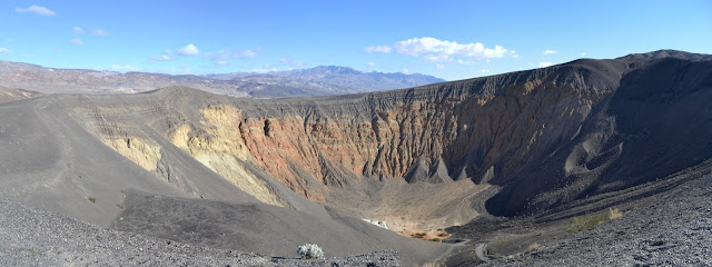
Death Valley National Park Locate the place. Our next stop is the Racetrack, but we cannot go past Ubehebe Crater without at least looking at it. It is a large hole in the ground and has similar, although smaller, neighbors, and it is quite the oddity. I look across at layers while a sign assures me it is volcanic in origin. Granite may flake away in layers, but I cannot pick out the edges of them if they are not flaking. I also look across and stand upon a dark layer that seems to have settled upon everything like grey icing. The layer seems to be cinders. The sign explains further about the volcanic action, how water sank down and met magma producing superheated steam that gathered until a weakness blew out this pressure cooker with no safety valve. Ubehebe Crater. One trail leads along the edge to the right and to other nearby craters and another leads along the edge to the left and down into the bottom. A circuit may also be made. We have a schedule to keep with

Eureka Dunes

Image
Death Valley National Park Locate the trailhead. Sung gave me a last minute chance to return to Death Valley and jumped at it. This did mean giving up another trip to Joshua Tree, but the logistics of finding a hike while others are focused on climbing rocks is not as simple as finding a hike with someone focused on poking around and hiking. The first stopping point is Eureka Dunes. We approached them in the late afternoon along the best road in, a wide strip of washboard dirt road the average passenger car would be capable of traveling. The dunes are at the far end of the valley on this approach, a sudden large pile at the end of a vast flat like some giant has just emptied his shoes after the beach. The mountains behind them make them seem small although they are some of the tallest, rising nearly 700 feet above the dry lake bed. They got more impressive as we got closer. A huge pile of sand rises in the distance. We settled into the camp, a place with a few concr

Toro Ridge

Image
Toro Canyon County Park Locate the trailhead. The hike up the ridge in the lesser known portion of the little known county park of Toro Canyon remains an excellent hike and I decided to force my poor mother up it. It seems I have forgotten the steepness of the start and the first half of the trail is a bit more than she is looking for, but the recent rains are making it hold together nicely under foot and it does level off eventually. We have views of the better known section of the park with its climbing rocks and picnic tables and gazebo as well as the houses above it with their palm lined driveways. All the views to the north and east are somewhat obstructed by vegetation, then we turn a corner and climb one last little bit for an unobstructed view of Carpinteria below. Anacapa Island is its usual distinctive self out across the Salt Marsh Preserve. Looking down the coastline past Carpinteria and along Ventura. I poke along the top of the ridge, but leave the re

Chorro Grande Falls

Image
Los Padres National Forest Locate the trailhead. Taking the very long way home, I decide to stop at the Chorro Grande Trailhead and have a look at the falls. The rain has been coming down, so it is reasonable to think they might be flowing. There are only two cars there when we stop and one goes with whoever is target shooting south of us. We quickly climb to the rocks that give a good view of the waterfall, which does have water going over it, but only a trickle. Waterfall over the hard rocks along Chorro Grande.

Mount Pinos

Image
Los Padres National Forest Locate the trailhead. There has been plenty of snow dumping and the weather looks good, so it is off to Mount Pinos to crush some of it under new snowshoes. The road is clear all the way to the top with only a few wet spots to worry about actually being ice and there do not seem to be too many people about as we get there. A bit of snow on everything. We head up first along the road and then along a somewhat lesser used path that is a little more direct. It is above freezing but windy so still feels very cold. The trees full of melting snow rain down, especially when the wind gusts. We rather want to get out from under them, but find ourselves coming into cloud before we do. Some pine needles show a little bit of thaw and freeze. It is nice out in the open, for a little bit, but it is a bit misty in the clouds. As we go further, the mist gets harder. Under the trees again, the melt is even more pronounced. In view of the radio facil

Fremont Ridge

Image
Los Padres National Forest (map link) After the unsuccessful attempt to follow Fremont Ridge up from Fremont Campground, I decided I would take it down fully expecting to find that I had missed it by mere feet while trying to find a way up westward instead of northeast past the large yurt. The road is easy enough to find, especially after overshooting to Painted Cave Road (where a "road closed" sign adorns Camino Cielo) and coming back. There is a large turnout just east of the gated road it follows for much of the route, but no sign to confirm I am in the right place. The road follows along under some large oaks, then out to an area of rolling hills and sandstone boulders with some glimpses into the backcountry. The valley area to the west side of the ridge and on toward the pass. The vernal pools are filling out in the boulder field.

San Ysidro

Image
Santa Barbara front country Locate the trailhead. Under the threat of rain, I decided to wander about the San Ysidro area for a bit, heading up to the waterfall via McMenemy and Girard Trails, then hitting the Old Pueblo and Wiman Trails on the way back. It is sprinkling lightly as I start up the trail, which is generally gives solid footing in the mud although some spots, easily noted by the slipping footprints adorning them, are not good places to step. The trailhead includes a 99 year old survey marker for what was the Johnston estate. Traveling by the estates along West Park Lane, the fountains have been drowning out any creek noises for a while, but today the creek is louder. Turning down McMenemy, the creek is not flowing high yet in spite of all the recent rain. There is always something downright pleasant about a eucalyptus grove in light rain and today is no different. Green things are starting to pop up on the stark hillsides as I start to climb to the bench

Bernard and Little Berdoo Peaks

Image
Joshua Tree National Park Locate the trailhead. For the second day of the Holiday Hooplah, we again decide to go on the longer hike of the two choices. Bernard notices that the peak Bernard has a twin of sorts to the northwest that is actually slightly taller. Bernard also has a twin who is slightly taller, so it is decided that this second bump is Loren, for his twin and we must climb it, making our hike a little longer even before we begin. Our beginning is from the side of a lumpy path through the desert that requires high clearance and our hike starts up a wash again. This wash is a lot more open and easy to travel than the one yesterday and our much smaller group moves smoothly upward toward the peak, sometimes hitting the false peaks along the ridge. The station at the top of Bernard. There are also two reference marks of the same era. Photo by Bernard Mines.

Mount Minerva Hoyt and Quail Mountain

Image
Joshua Tree National Park Locate the trailhead. Bernard and I decided to head down to Joshua Tree to get in some guided wandering by joining the Hundred Peaks Section for their Holiday Hooplah. There is a choice of hikes on each day and a campfire and potluck to bridge them. For Saturday, we chose to do the hike to Minerva Hoyt, named for a woman who was instrumental in getting these desert lands protected. This was advertised as a 10 mile hike and was the longer of the two choices. We arrive a bit earlier than most at the Quail Springs picnic area and gathering my gear includes remembering the camera is still on the coffee table. I do have a backup, but it has a very low battery. Eventually everyone is gathered and signed in and we head out, aiming at a wash across the desert flat. We seem to be on a trail at the start even though this hike is completely across country. Crossing the brief, sandy flat on use trail to climb the mountains beyond.

Painted Cave fuel break

Image
Los Padres National Forest (map link) There are quite a few short hikes off of Camino Cielo. Explore it and there is likely a new one waiting somewhere. For me for this one, someone else actually did the exploring to find it. I just noticed there was a geocache in the middle of supposedly trail free area and in this cache is a " travel bug ". These things get lost all the time, but it belongs to someone, it was given a goal, it builds up a history as it moves from place to place and hand to hand, and this one has been in one place for three years. Sure, it is illogical to care about them, but it is also a stunning day for a quick afternoon butt-kicker at the top of the ridge. Some minor reconnaissance shows a fuel break in satellite photos and a dotted line with no designation on the 1995 Goleta and San Marcos Pass quads between San Antonio Creek and Maria Ygnacio Creek. Arrival at a small turnout with cables to block motorcycle travel, but otherwise the same as

Cathedral Peak

Image
Santa Barbara front country Locate the trailhead. I am feeling it is about time to tackle Cathedral Peak again, so it is off to fight for parking at Tunnel Trail on what is meant to be a cool and clear weekend day. I can only manage a spot that clocks a quarter mile before even reaching the gate to start on the trail. It is a minor addition to a much longer plan. I climb Tunnel along the old pavement that becomes quite broken after the water pipe. The trail follows the left fork of the catway briefly, then turns off to the right into the chaparral while I continue on Jesusita that forks off to the right after not much longer. The pool is full again, but there is only a small trickle of water flowing through the creek as I cross it and leave Jesusita for the use trails that clamber up Cathedral Peak and around Seven Falls to Three Pools. There is a little bit of storm damage to the otherwise smooth paving at the start of Tunnel Trail. Looking up at the southern pea

Arroyo Burro Trail (front side)

Image
Santa Barbara front country Locate the trailhead. Arroyo Burro is unique among the front country trails climbing to Camino Cielo. All the other routes find their way to the top in 4-4.5 miles, but this one takes nearly 6 miles to reach the top. It does not get that long by simply climbing on an easy grade like the various roads. It explores everything, climbing and dropping and climbing again, first on ridge line and then into a canyon and up the edge. A 3% chance of rain this morning has materialized into brief, hard bouts of falling water, but I am set on climbing the hill. The start is familiar at the west end of Jesusita Trail. The mud from the recent rain is an odd thing, sticking together enough so it is not slippery, but not piling up much on my shoes. It is an effort to extract each foot for the next step. Fortunately, this does not last very long. Heading up into the rocks and chaparral and clouds. Early on, a trail comes up from Stevens Park that is not

Snyder Trail

Image
Los Padres National Forest (map link) Snyder Trail holds a mystique for me, somehow, but my attempts at it seem to always be insufficient. The first was early in college on some scorcher of a day with the waterfall as a destination and our water draining quickly. With the drunk water approaching half of what we brought, we decided we did not have enough to get back up comfortably and should turn around immediately. We were out of water before the top. Since then, I have just gone to Knapp's Castle and once dropped down a bit further, but never any try with real commitment. It is probably that waterfall that brings the mystique. Knapp had a building of some sort down there and is supposed to have piped music down to it and had colored lights and it must have been some sort of trippy party hideaway. His guests were able to drive down to it via a spur road from the main one that can still easily be followed down to the power lines below. Now, I am not even sure if the s

follow by email