Posts

Showing posts from April, 2018

sketches

Image
A pair while backpacking, one before getting snowed on and one before getting snowed on again. Water pours from a pipe from the dry hillside. A sketch in the gathering gloom camping at Mission Pine Spring . The rocks for miles of White Ledge have quite interesting texture.

Western Plateau, Elliott Peak, and Hawk Canyon

Image
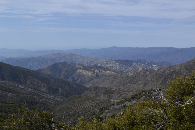
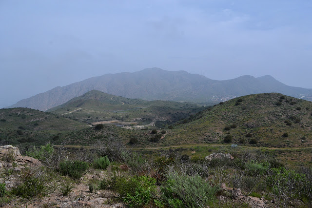
Conejo Canyons Open Space Click for map. After missing one, I am out for another round of trails for the Conejo Open Space Challenge with geocahers. Today, our required trails are a pair of short pieces in the Conejo Canyons Open Space: Elliott Peak and Hawk Canyon. They are joined together with a long and elaborate loop that goes for an estimated 8 miles. I arrive a bit confused about where to start. We are only five strong today and Matt says I am in charge because I was the one doing the little bit of pushing to make sure everyone remembered there was a hike scheduled for the day, what it was, and determined a meeting time. (I did all that for the last one, too, and was not even going.) This is unfortunate because, as I say, I seem to be a bit confused about where the start is. I promptly compound it all and get somehow more confused and we go ahead and start down a different trail which will get us to our loop and does mean we have a nice parking lot to leave the cars. It

San Rafael: Big Cone Spruce and Cachuma Mountain

Image
Los Padres National Forest DAY 1  |  DAY 2  |  DAY 3  |  DAY 4  |  DAY 5  |  DAY 6 Click for map. I awoke in the dark to mist on my face. The night had been clear with bright stars shining where I could see through the leaves, but had turned dark. My light showed more mist coming down. It was raining. I could see quite a bit of water on my quilt already. It had been raining for a while. I looked around for some rocks to hold down the emergency blanket again and saw a blanket of white developing. It was actually snowing. The breezes of the evening had died to nothing and it was the most peaceful moment looking out on that fluff dropping down. And then I had to get up and deal with it. The emergency blanket is a lot easier to deploy a second time, so I got it open, got some rocks to hold it down, and tucked in underneath my rain coat to sleep the rest of the night away and get up to a blanket of white. It is an all new camp in the snow and early morning light. Ther

San Rafael: White Ledge

Image
Los Padres National Forest DAY 1  |  DAY 2  |  DAY 3  |  DAY 4  |  DAY 5  |  DAY 6 Click for map. I got cold in the night and being hatless, had to just grab the coat hood and pull it on my head. The rest of the coat spreading out over my shoulders was rather nice in the dark chill. The morning is clear and crisp. I will not be following a lot of new trail today, but there is some nice stuff to repeat. I wave to the folks at the cabin and head off along the trail. The junction marking the east end of the Manzana comes quick. The rest of the Sisquoc would be new trail, at least down to the trail work a couple months ago, but is a little long added to getting up to Cachuma Saddle for just two nights of food. I turn up the Manzana as it climbs along the south fork of the river to Lonnie Davis Camp, a rather nice spot, and then then out into the high and dry. It is not nearly so dry as my on other visit. On the way up the south fork and looking back toward the cabin, wh

San Rafael: Upper Sisquoc

Image
Los Padres National Forest DAY 1  |  DAY 2  |  DAY 3  |  DAY 4  |  DAY 5  |  DAY 6 Click for map. The night was not so bad as I feared it would be. There was a lot of room for it to be worse. As unprepared as I felt I was, I was mostly comfortable to be honest. There are ultralighters who probably think that means I have excessive gear. The wind could have easily challenged my setup and won during the night, but it stayed a breeze. We do not listen to that sort of person. While the emergency blanket probably kept in more moisture than it blocked, it also kept the wind from stealing my warmth. To show me just how bad having that warmth stolen is, my Platypus bags have a half inch shell of ice around the sides and my drinking tube is frozen quite solid. The first time I left it overnight in significantly freezing temperatures, I had the good sense to empty it first. For some reason I have not been able to remember to do so since then. The gloom and cold and threat of weat

San Rafael: West Big Pine Mountain

Image
Los Padres National Forest DAY 1  |  DAY 2  |  DAY 3  |  DAY 4  |  DAY 5  |  DAY 6 Click for map. My quilt got a little moist in the night, but there was a lot of visible moisture in the air yesterday. What did I expect? My sheltered spot is practically dry. There is a spot by the table that is downright soggy. Around behind the oaks beside me, there is a set of three standing dead and very tall pines and I am well inside their topple zone. Arg! Must be more careful with site selection. I get some breakfast and head out in a cloud. I have in mind to go climbing up what peakbagger calls "Peak 6080" , but could sensibl called Mission Pine Mountain on my way out to West Big Pine and then to Upper Bear. This one is going to be a long day and I am not even sure how long. At least the uncertain portion comes early so I can try to make it up. Rocky outcrops are near but almost lost in the cloud. Just down the trail from camp is another stream that I am sure i

San Rafael: San Rafael Mountain

Image
Los Padres National Forest DAY 1  |  DAY 2  |  DAY 3  |  DAY 4  |  DAY 5  |  DAY 6 Click for map. It is already nearly 10 AM as I arrive at Cachuma Saddle to start on 6 days of peak bagging and seeing new bits of the San Rafael Wilderness. I checked the Santa Ynez weather and it says it probably will not be too hot out here for those days. Assuming all goes well, I will finally finish off all the Hundred Peaks Section listed peaks for Santa Barbara County and get in an extra along the way. Some of the days are a bit long, but all the camps have good, reliable water. This bit is not new, which does not help when facing a lot of miles on a road. Still, there is good view, and it can be easy enough to think about that and ignore the rather stunningly wide nature of the trail. Sunny, but breezy and chilly, it is not quite time to try out my new sun sleeves and see how they are against the midday sun. The old sign at Cachuma Saddle and the start of the road. This was pa

Old Boney Trail

Image
Rancho Sierra Vista/Satwiwa Point Mugu State Park Click for map. Back not far from where I was hiking last week, I am out to either hike up to Tri Peaks again or take a big loop along the side of Boney Mountain. I probably should have chosen before starting, but I am still pondering. Although I want to go up to Tri Peaks again, I sort of want to do it via a different route than the one I have already done, so most likely this will be the larger loop to new spots. My start is new too. Previously, I started from by the cultural center, which has parking behind a gate that locks at sunset giving an annoying deadline for getting back. This time I am using the trail at the end of Windy Drive that everyone else seemed to be using so that I have no timing worries. Wide trail past informative signs to start off at the end of Windy Drive. The trailhead has a sign about fire inspired by the Springs Fire of 2013. My previous trip was just 3 months after that fire, so this whole

Vista Del Mar and Prickly Pear Trails

Image
Dos Vientos Open Space Click for map. For the third (only the second for me) COSCA Challenge related geocaching hike, we have two required trails planned: Vista Del Mar and Prickly Pear. The main streets in the areas do not allow parking and most side streets seem to be gated, so we met at Dos Vientos Community Park, where there is quite a lot of parking. I had thought that this would be high enough and far enough from the beach to get out of the coastal gloom that has recently closed in, but no such luck. The area is socked in. There is a little lifting as we wait for the start time, but not enough to see the little mountain peak. Due to the holiday, there are only five total once start time rolls around. We take off across the park, somewhat uncertain as to where the trail is exactly. It sorts itself out easily enough as we get into the right area and we start up Park View Trail. The foggy hills across the park. There is no sign as the trail splits. The right goes of

follow by email