Posts

Showing posts from April, 2020

Rhododendron Trail

Image
Prairie Creek Redwoods State Park Click for map. The general expectation is that the rhododendrons should be blooming throughout April and May. I've seen them blooming in planted areas beside the forest and along the freeway on the way up, but still haven't seen any actually in the forest. Being halfway through that blooming time seems long past time to change that. I checked to be sure the state parks in Humboldt County are still only in a soft closure allowing people to walk on. It adds about three miles to a longer loop to hike in from outside the park, but flowers! Bright red flowers! Seeing Humboldt Lagoons State Park blocking off parking next to the park as well as in the park was worrisome, but Prairie Creek Redwoods happily left a little at the edge of which no one was taking advantage. It was mine and being next to the Elk Prairie Trail, I decided to walk along it to the Rhododendron Trail. First I watched a couple of the elk on the far side of the meadow. R

South Fork Trail on Trinity River

Image
Six Rivers National Forest Click for map. When I went out to see the not-really-world's-largest tanoak , South Fork was there for a backup plan. Now I'm finally getting out to see it. I wasn't sure how far I would get, but thought there was hope I might get past the ford with the rather dry winter the area has had. The road in is mostly paved and frequently narrow, sometimes for long stretches. Signs are missing and one or two driveways try to look like road, but mostly staying left at the branching works. Of actual forest roads, there are two places for river access on the right along the way and then a final loop which is less rough and steep on the right side. There is plenty of parking for a dozen vehicles and even a dispersed camping site for all who make the correct guesses to get there. The trail itsel is not signed, but there is a large sign board for information across from it to help one find it. It is a little less well signed than I expected for a named

Beith Creek and extras

Image
Arcata Community Forest Click for map. I hiked the Beith Creek loop again, this time in the rain. I also hiked it the week before and finally took one last little bit of trail I'd not taken before. That bit of trail comes out in a different part of the neighborhood and allows the loop to be extended nicely through a little neighborhood park. There was a particular trillium along that bit of the trail that I wanted to see again and get a better photograph, so I did it again today. I bumped into mountain bikers on the road sections and a couple hikers on the narrower sections when it was sunny. This time, there were very few people around, but still a couple. I was mostly wanting to see if there are rhododendron around, so it became mostly a wildflower hike. None of those I was looking for, though. The trillium lasts forever. These aren't much worse than they were last week. The sort around here sometimes turns purple when it gets old. I headed right at the loop b

HOWTO: free offline electronic maps on Android

Image
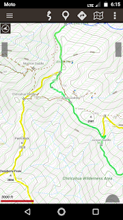
It is always better to have a paper map of some kind when hiking in an unfamiliar area, but they can be hard to get hold of and the expense does mount up a bit. If one has access to a good printer, CalTopo is an excellent resource to create maps. It's still possible to do quite a lot of mapping right on the tiny screen of the pocket computer we all like to call a "phone". Before I headed out traveling on the first day of winter 2018, I tried quite a lot of applications (er, "apps") for offline mapping. I'm uninterested in anything that requires a connection I likely don't have. These all had one thing in common: they are free. I have never attached a credit card to the app store because I live in fear of pulling my phone out of my pocket and finding it has just bought something random and expensive. Perhaps this is a phobia. I could probably attach a gift card to it, but I'm also cheap. Free Apps There are two apps I kept at the end my trying: A

Elk River Trail, plus another Quest

Image
Headwaters Forest Reserve Click for map. I need to get a hike with some length to it, so I started looking for things accessible via CA-36, then gave up and went out for another Redwood AdVentures Quest (link to interpretive trail brochure) . It seemed a bit of a gamble, but it's close enough to just go for it. There would be no good parking if they closed the gates, but they have not and there are spaces available. Bathrooms are closed, but the trail is open. I'll hike the South Fork Elk River up to its little bit of old growth once again. Just a bit of warning on entry. Plenty of parking. Most of it is on the other side of the trees, but some is to the right and by the pickup. New signs include "pack it in, pack it out" on the garbage that isn't getting collected and "social distancing" requirements. This trail includes a mile that is wheelchair accessible. First up, that Quest. It says to start at the Quest box a quarter mile alon

Redwood EdVentures Quest at Redwood Park

Image
Arcata Community Forest Click for rough map. My second backpacking trip on the Lost Coast fizzled with an email that permits were suspended on the 28th. Mine was for the 29th finishing today, so no additional watching the sea lions play for me. I guess it saved me from one dreary rain day and a second rather heavy rain day. What to do? Another Quest? There's one at the Arcata Community Forest. It's just the smallest circle through the trees beside Redwood Park. The lots are open for parking with just a sign stating that the gates will actually be getting locked after January. I'm sure I'll be out before dark. I found my way to the larger lot which is also the lesser used, so there was plenty of space. There are a few groups using the park. A slackline hangs slack at one end by a group of three spread out and a larger group of 20-somethings are collected at the other end almost spread out. Otherwise, there's a few singles scattered about the grass with one

follow by email