Henninger Flat
Angeles National Forest
Locate the trailhead.The old way to Henninger Flats is to start at the bottom of the Mt. Wilson Toll Road and walk up. The road has a gate on it that is only open sunrise to sunset but now hasn't been open for years because a large section of the road, visible from the gate, has been removed by a landslide. With the traffic of people who go up the mountain from around here, it might be expected to have a good trail bed again, but it does not.
Since the gate never opens, one must start in at some other location or trespass. If the sunrise to sunset time limit is no problem, then the Eaton Canyon lot is a good starting spot. If not, between the two is a small dirt lot along Altadena Dr. Either way, the reason there hasn't been a good trail bed made by the passage of people is because there's another way up using the Eaton Canyon trail directly across the riverbed. From the lot on Altadena, one may have to go east a little to get to it.
Of course, I didn't know this when I started. I knew the bridge for the road was a short ways up the river so followed the trail to Eaton Canyon falls as far as it and then turned to cross the area of landslide. I saw one other person do it as I came up and met two more as I did it, so there is still some traffic across this loose dirt. It must be admitted that this is the more pleasant way up since it is all easy road grade.
 |
|---|
| The trail climbs the south side of the mountain, so LA, Pasadena, Altadena and an increasing array of other places are all visible from the very first bit of elevation, at least on a clear day. It's early afternoon, but winter hours, so the sun is already a little low in the sky. |
 |
|---|
| The bridge for the toll road across Eaton Canyon and landslide (overexposed on the right) closing the road. Right now the river is virtually dry. |
As I climbed, I did find the top of the trail up from Eaton Canyon which looked rather like another road, though this one would be more of a jeep trail and doesn't care about the grade so much. This is the way most people come up and the way I went down later. The toll road has benches at various places along the way for sitting and looking out at the valley below. Each step brings a little more of it into view.
 |
|---|
| From a bit higher up, LA is still easy to spot and Pasadena is no longer hiding behind trees. Northwest of LA, Glendale is peeking out from behind the hills. The large street can be picked out by the row of palm trees in Altadena. At the bottom, an occupied bench along the road. |
But one shouldn't spend all one's time snapping photos of the cities laid out below. There are places to be going. And moons a few days from full to be rising.
 |
|---|
| The moon was about four days from full, so came up a fair bit before the sun was going down. |
A second area of slide, though not as bad, has dumped dirt over the entire road somewhat more than halfway up. This marks the other end of the road closure. Here, the mass of humanity has bothered to make a new trail bed with their ever passing feet.
Eventually there is a sudden outcrop of trees here on the south side of the mountain. Henninger Flats is a tree nursery. Unlike Grizzly Flat, it is still being used as such. I've started to notice sudden stands of tall trees like this as the hand of man, but it is particularly noticeable when on the south side of a mountain.
 |
|---|
| The road comes up around a bend and over a little crest to show a stand of trees that has a distinctly out of place look to it. Also the land looks to have been flattened further from the usual state of a flat. |
The flat is a campground as well as a working tree nursery. Currently, the campground is closed and the toilets lighted but locked. An old fire tower has been placed here. It looks very funny since the view from it, about 10 feet up is almost as extremely limited as from the ground, but it was not here when it was in use. Others say there is some bit of museum here, but I don't know if there's more than the few things outside or if the building houses more.
Above, the road is still in use and continues up to Mt Wilson. Somewhere, another trail heads off toward Inspiration Point and Echo Mountain. This must be a very reliable road since other places that have had one of their two exits removed have been closed down until repairs can occur but they don't seem to be repairing the lower part of this road.
 |
|---|
| The road above Henninger Flats should be easy to travel clear up to the top. |
I was told that the way to Inspiration Point was quite long and somewhat hard and decided not to go onto it. I continued up the road, though, and turned left when it split and the signs pointed right. The left fork went around the back of the nursery, past picnic tables in long grass, so an unceremonious end. I climbed a mound of dirt and from here I sketched and watched some of the sunset.
 |
|---|
| As I started sketching, the very late day light made the depths between bumps of hills and mountains look quite misty. |
 |
|---|
| As I finished, the sky was turning very red although the sun was still a fair ways up in it. |
I turned back with the sun setting and the moon ready to light the way when the direct sunlight had gone.
 |
|---|
| Sunset looking out over the valley through the trees of the tree nursery at Henninger Flats. |
 |
|---|
| Sunset near Henninger Flats. |
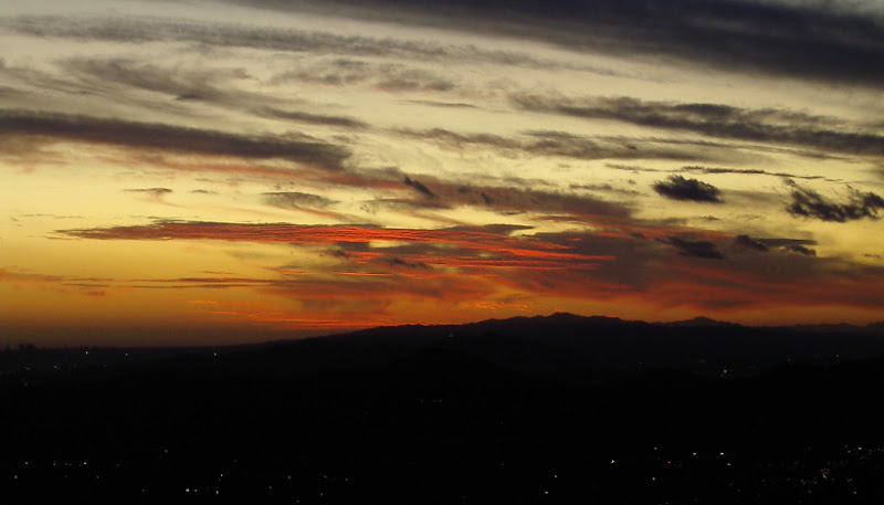
 |
|---|
| The sun has set, so the picture is getting a bit grainy. |
 |
|---|
| The lights come on in the city. |
 |
|---|
| And the lights come on all over the valley. |
 |
|---|
| The very last of the sunlight disappears behind the hills. |
I made it over the road closing debris at the top before the darkness had really set in. As the sun went down the moon already hung high in the sky to light the way and the wide road was easy to light and easy to travel. I didn't need to take out my lamp for any of the trail. I met two coming up (separately) on my way down who also did not feel the need to hold a lamp. Before turning down the part of the trail I didn't know to Eaton Canyon, I took one last photo of the lighted city in the distance.
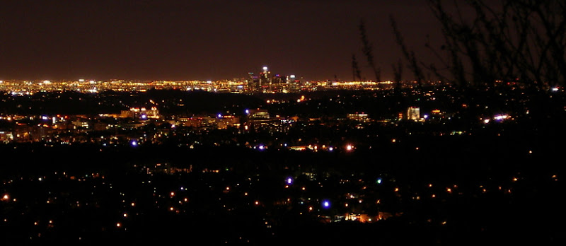 |
|---|
| One last photo of the city at night, LA in the distance and Pasadena and Altadena in the foreground. |
The final bit of trail was a little steeper and slightly rougher, but still easy going. At the bottom, I turned back up the canyon instead of toward the parking lot down the canyon in order to find where I had crossed over before then climbed out to find my car almost lonely. Just two others now, probably belonging to the two I saw going up.
©2008 Valerie Norton
Posted 22 November 2008
Liked this? Interesting? Click the three bars at the top left for the menu to read more or subscribe!


Comments