Rubio area
Altadena front country
Locate the trailhead.
Last week, I noticed this trail heading along the back of the water facility at the end of Rubio.
 |
|---|
| The trail heading out behind the water facility, photographed the week before. |
This trail looks to me like it gets a fair bit of use. I looked at the satellite photos to see where it might go, but couldn't be very sure from them. They did show that there is likely a mile or two of trail heading off around in the Eaton Canyon direction. It also showed a rather clear route down from the Rubio trail.
I started as normal for Rubio, with the turning off Lake at Palm, then turning down everything that says Rubio on it and parking in the corner. I started down the trail as usual, watching for the trail down. There was a large dirt spot to the side of the trail as though people liked to stand out on that bit for the view, which so often is a good way to hide a trail junction. It turns out it was the junction I was looking for, so I headed down. The trail is little used but bears the markings of development and maintenance. Bush branches had been painted and cut at some point and the trail took a few short, but extant, switchbacks leading past a random abandoned mattress to a seeming campsite by the creek.
 |
|---|
| Stones set in three rectangles with a piece of an old camp stove at the bottom of the trail into Rubio. The pipe behind comes up from something buried. |
The trail then had a spur that went down the creek to the bridge and some other structures for the water facility. They've got cameras pointed out at a few points including this one. The proper trail heads right up the other side of the creek for about 20 feet, then passes the back of the facility with more cameras to watch for suspicious folk. Along the back, it looks every bit like it was once a road, although that could just be the result of how the facility went up. The trail continues into the little crevice of a canyon next to Rubio and on up the edge. The slope of it was still like a road, but usually not very wide with a few spots that were almost gone.
 |
|---|
| A look back out of the first, tiny canyon east of Rubio to the neighborhood. |
Coming level with the floor of the canyon, the trail proceeded back along the other side, still with a light upward slope. On the north slope, it was cool and shaded and more stable showing much more width than would be build for a trail. Around the edge came a view of more of the city as well as the spot where the city sucks up all the water left in Rubio in the middle of the debris basin that is meant to protect the homes from any catastrophic flows.
 |
|---|
| The city sucks the mountains dry of every drop that comes down the canyons. |
The trail kept going around the edge of the canyon and out onto the side of the mountain again. By this time, it was high enough up to actually go along the ridge between the canyon and the city, which it proceeded to do. Eventually it came to a bump it didn't want to climb and split to either side instead. The one to the south seemed less traveled than the one to the north, so I left that one. Then came the best evidence that this was a built route.
 |
|---|
| A National Forest boundary sign. Everything beyond this point is in the National Forest. |
Past the sign, the trail was still clearly following a road bed. It passed into the next canyon and here it got less passable. The problems with getting through were more due to the chaparral, and not the lack of a flat spot to be. Sometimes it wound back and forth from shoulder to shoulder looking for a soft spot through the vegetation. There were still cut bushes, but also broken branches and the yucca twisted up so their leaves to poke hikers, indicating very opportunistic "maintenance" rather than anything organized.
 |
|---|
| The second canyon along the way is slightly bigger, but still doesn't appear to have any water flow just a day after heavy rain. The flood control on up the canyon may actually be part of the old road bed and appears to maybe be metal instead of the usual concrete. |
The road still climbed a little as it went into the new canyon. There were a few spots where runoff had lowered the trail annoyingly as I got further into the canyon. Each barrier bore the signs of trail through it, so I was still following a used route. Then I came to some rock slide area that didn't quite seem to have a path through it. It looked like it could be crossed by the determined hiker, but no one had decided to do so. I looked at the annoying slides and the roadway solidly cut along the other side and thought about how little time I really had. Eventually, I turned back.
 |
|---|
| The roadway on the more sun-baked sides is much less stable. The rocks have fallen from under and onto the roadway making it an undesirable passage. |
 |
|---|
| The roadway continues on in spite of the discontinuity. |
 |
|---|
| Further up, the roadway is even more clearly cut into the side of the canyon. |
Coming back, I came upon a water tank I hadn't noticed on the way up.
 |
|---|
| A water tank, fairly well hidden among the growth and the rear even with the ground, full of inky black water. |
 |
|---|
| The water tank hiding in the underbrush. |
I climbed up the hill from the water tank. It seemed much steeper than I thought I'd come down. In fact, I was fairly sure I hadn't come down. I climbed it with increasing annoyance.
 |
|---|
| Another longing glance at the rest of the route that could not be reached. |
 |
|---|
| A view of the city below. |
 |
|---|
| A view of more of the city, including the center of L.A. |
Of course, getting up high gave me a much better view of the surrounding city. Down in the bottom of that second canyon, there was a large trail along the edge of the city. A much smaller trail made its way up the canyon itself.
 |
|---|
| A trail along the edge of the foothills behind the houses. Two walkers are even using it. |
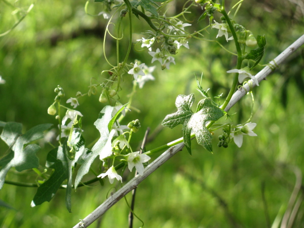
I continued along the path I had found even as it seemed quite wrong because I had not seen another. Of course, the vines across the path that hadn't been pulled away were very suspicious.
 |
|---|
| A flowering vine. I think these are the ones with the giant seed pods in summer, mostly by process of elimination since the flowers aren't morning glories and the leaves aren't grape. |
Which is how I made it up to something that can't really be missed but I was sure I hadn't been anywhere near. This is where the trail ended, although use trails tried to make their way back down the mountain. They didn't look attractive to me.
 |
|---|
| The bases of there very high voltage transmission line towers that follow the front of the mountains climbing from Eaton canyon area. |
From there, I could look down into Rubio and knew exactly where I was, but not quite how to get where I wanted to be later. I didn't really want to try the faint route headed downward since some of what was below me didn't look like something I wanted to be on. I turned back, determined that there had been a trail off somewhere along the line. Actually, I was pretty sure it would be by the water tank. I would go to the edge and look for trail below me, but there wasn't much promising. A few times something far below me might be it. When I was able to see enough around the lumps of the canyon, it actually supported my suspicion that the tank was where I went wrong.
 |
|---|
| Looking down from the base of the transmission lines into Rubio canyon. The trail is easy to pick out. |
I finally made it back to the tank, dreading that I might have to climb back up again even while being certain I wouldn't. Sure enough, there on the far side of it, there was actually a route heading down below the thing instead of above it. The sugar bush was hard to get through and there seemed to be a couple of routes available, but really it was a couple of trails.
 |
|---|
| The right trail back snakes downward from here. The trail up to the transmission lines snakes upward in the upper right corner. |
I resumed a steady, shallow descent and things looked right and familiar and so I was happy. Actually, if you look at the picture above of the water tank, you can see a bit of trail behind it. That is the trail I should have been on. Along the way, I saw what may be the only deer I've seen in the Angeles, and is certainly the only one I've seen on this side of the mountains.
 |
|---|
| A deer, stopping to look at who is making all that noise with the point and shoot with a big zoom. It wasn't worried much about me and kept going back to eating. |
 |
|---|
| What I mean by "this side of the mountain" is, of course, the side with all the city stuff on it. |
And so I came back down fairly uneventfully. Not much other evidence of animals. There was this old nest.
 |
|---|
| An abandoned bird's nest in the branches. |
Once I got down, I found odd residents waiting for me at the bottom. They said they'd spotted me up on the ridge, just beyond where I'd seen the deer, from their roof "because you move". They'd watched me and wondered how far back I'd gotten. One guy said he wanted to go up to where the power lines were and follow the ridge on up, apparently unaware that there is a trail that goes right up there even though he likes to run the trail up to the ridge. So it turns out more folks than the water facility were watching me.
©2010 Valerie Norton
Posted 7 February 2010
Liked this? Interesting? Click the three bars at the top left for the menu to read more or subscribe!


Comments