Altadena front country
Locate the trailhead.
I haven't been hiking in a few weeks and even though it wanted to rain again today, I went out. Even out into a canyon. Because I can now, I parked up at the top of Mt. Wilson Toll Rd. and passed through the long closed gate to the bridge, reducing my rock hopping crossings by one. In spite of the threatening rain which had even materialized once earlier, many people were out on the trail. I circled down from the bridge to the trail that passes under it to the falls.
 |
| Almost at the mouth of the canyon, there is a funny concrete thing like the one the fishermen in Fish Creek said was for measuring the flow of the river. |
The very first crossing had a shallow ford close at hand and a high tree or rocks quite a bit out of the way for crossing. I decided to test my boots right off in the ford. They held water until I stepped in something too deep when they let a little bit in the top. I found rocks for all the other crossings, although sometimes not the rocks that were being used by others.
 |
| While not waiting for a huge group help each other over what didn't look like the best route anyway, I came upon this natural dam keeping the bit I was on dry. |
The second crossing was still dry, but very soon after the rain started again. Not very hard, but enough and with sufficiently large drops. I got out my rain jacket and was already in my rain pants. Soon, I was to the waterfall.
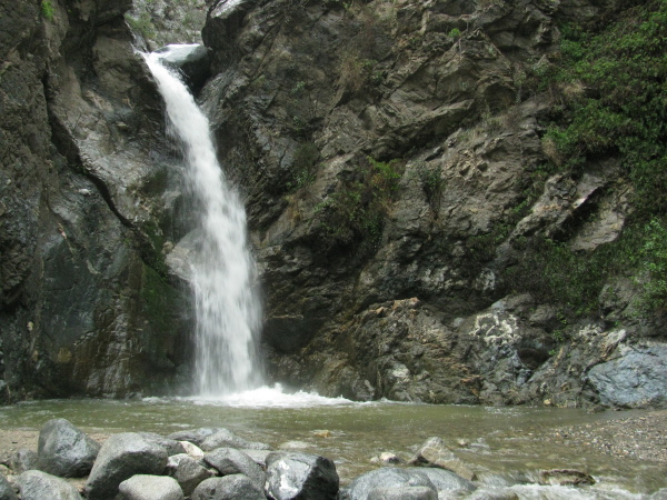 |
| And this is it. The waterfall up Eaton Canyon. |
 |
| The top of the waterfall is still a bit stopped up with a boulder. In this one, the rain is quite obvious. |
It was still raining when I got to the falls, but I decided to try to find a way to sketch something anyway. I found an oak around the bend and up from the creek bed to sit under. I could see sky through the leaves, but there wasn't all that many drops. I sketched in the occasional drips. The brush pen was a little different in the humidity.
 |
| My sketch of a couple trees growing down in the flowing water. |
While I was sketching, a group of four came up, the third carrying a machete. One has to wonder what a person on such a well traveled trail was expecting to need to clear. They left again while I was packing up, but the fellow with the machete was hanging out alone further down the trail when I got there. Maybe he was going to find something to chop anyway. You never can tell with people. The stream of people coming up after that wasn't quite as large as the stream coming down in the rain was, but got thicker at the bottom as people had realized it wasn't raining again.
 |
| I found another waterfall, of sorts. This dribble of water was coming down a vertical of over 20 feet covered in these ferns. |
 |
| Some oaks clinging onto the nearly vertical cliff wall. |
 |
| Some non-native invaders making a small cave over a bend in the creek. |
 |
| Next to the bamboo was this cute little pool with a mysterious wall build into the rock. |
 |
| The flood control structure I experimented with my camera on when it was still fairly new. |
 |
| And so soon, I am back to the mouth of the canyon. |
 |
| Looking out over the creek on the other side, there is not so much canyon but a wash instead. |
 |
| A bit of the only section of pavement on the toll road has failed long ago and long been replaced but never removed. |
 |
| Looking down into the wash and the mouth of the canyon from near the top of the Toll Rd. shortly before making my way back through the gate. |
©2010 Valerie Norton
Posted 6 March 2010


Comments