Angeles National Forest
Locate the trail head.
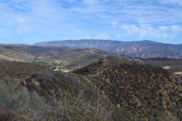
It's cooling down, a little anyway. I decided to head over to Townsend Peak in the Los Padres administered area of Angeles National Forest. The peak itself isn't much, but there's plenty of trail behind it to check out, including quite a bit that was removed in the 1995 Whitaker quad leaving mostly fuel breaks. There isn't much for destinations unless one hikes through to Lake Piru, but I picked out a few monuments of various sorts to try to find. I'm sure I'll find something nice to look at along the way. Unfortunately, the printer insisted on rendering my map badly into black and white, leaving out the red, to increase the challenge.
Access off the 5 is simple. Just get off at Templin Highway and head to the old bit of 99 on the left. A left on the Golden State Highway doesn't leave a lot of road, but there's a strip of dirt after the "end" sign. Let the water tanker pass and then head up it a short way to the gate and park without blocking it. Why is there a water tanker? To supply the sprinklers that are running behind a little hill. Ask a silly question... the driver of the green truck a little down from a second water tanker probably knows why a little bit of dry forest land needs to be watered. There's another sprinkler head in a turnout next to the gate, but it looks like someone parked on it. Tread marks continue past the gate, but so do quite a few footprints. The footprints show a wide variety, it's not just one person coming up from Castaic on evening hikes. It is surprising to see so many, but it is hunting season so a lot of footprints can be found in surprising places. There's actually a couple flowers in bloom at the edge and a pull tab Royal Crown Cola can somehow still dressed in blue. (I missed that one on the way down, if there are any collectors.) It's a smooth climb to a tight corner where the view opens up down Canton Canyon and the tire marks turn around. Hill after hill after hill stretch out into the distance. The land gives an impression of being soft even as it stiffly holds steep drop offs.
 |
|---|
| Across Canton Canyon, Whitaker Peak rises just a little higher, from this viewpoint, than the surrounding prominences. When I hiked to it, I first went up the ridge on the right, then to the end of the road and followed the ridge from one of the communications sites behind it. |
 |
|---|
| Row after row of hills building to some tall mountains. The land isn't all steep. |
The road is perfect where it isn't getting driven. At a saddle, I turn back and climb a blockade of dirt to hit the peak. A few of the footprints come up with me along the trails that wind along the fuel break that is growing in a little. Along here somewhere is my first target, a witness corner that is, hopefully, far enough off the ridge line to survive. I keep a bit to the west to look down the side there, but don't see anything. Once there doesn't seem to be any more up to go, I check around for a benchmark. There was supposed to be one in 1935, it's on the map, but the recent maps without one seem to be correct. Looking around, the heart of Redrock Mountain is striking on the far side of the eight lane ribbon of commerce below.
 |
|---|
| To the east, and a bit north, sits the red face of Redrock Mountain. The Ridge Route, the original path north-south through these mountains, is the ribbon of dirt. Close by, there's only the fuel break and a triangular sign down on the shoulder below. |
 |
|---|
| The top of Townsend Peak is a bit flat and stands at only 3184 feet. The fuel break doesn't seem to be maintained as much here as further along. |
 |
|---|
| Castaic Lake on the other side of the grinding mass of I-5. |
Heading down, I keep even closer to the west edge of the fuel break and sometimes beyond. There doesn't seem to be a post anywhere, except a bent over tall yellow one. Maybe it's down below the road. Maybe I'll find it on the way out. The road continues around another bump in the ridge and ends in a big turn around. Old road goes down to the right while the fuel break heads up over more peaks. Prominent trails go down both. My next target is along the fuel break, so that's the way I go along with a swarm of footprints.
 |
|---|
| Now looking down Devil Canyon. Taking the fuel break up and the road past the water tower for a couple miles should bring one to a boundary marker. Good trail also follows the valley and the fuel break doubles back and climbs to the ridge again. |
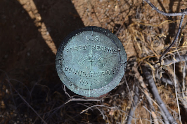
Coming to a sharp rock along the ridge, I find that the fuel break really is a trail as well. The trail follows around the edge of the rock and even has fencing to keep hikers safe from the drop. The fuel break splits again and I try to see if I can spot the boundary post that should be nearby from a distance, but cannot. Starting down the steep fuel break, I keep to the edge and check lower from time to time only to find that the post I am looking for is clearly visible and still quite good at the edge of the break. A county surveyor mark for the Temescal Land Grant hasn't fared quite so well.
 |
|---|
| The boundary post (no. 192) for the Zaca Lake and Pine Mountain Forest Reserve, then the Santa Barbara National Forest, and in 1925 the Angeles National Forest as it remains. The county surveyor mark is also marked "Temescal No. 1". |
 |
|---|
| The 1905 reserve monument and a very damaged county surveyor monument (not dated) with a burned, but standing, witness post between. |
Having found one boundary post and not realizing how much of the backtracking can be eliminated using the existing trails in the area, I decide to leave the next one and go for the unremarkable benchmark instead. The original plan is to take the other branch of fuel break back to the old road, but I decide to split the difference and start down the trail in the bottom of the canyon and then climb the second finger of land along some deer trails. After all, the land does seem soft. A sign points out a mining claim and notes that there is to be no activity of any kind that results in the removal of minerals from the ground. Soon after that, I cross the dry creek and start up the deer trail and finally leave the footprints behind except for the first deer prints I've seen. The deer prints are few and old. Scat is plentiful, but also old.
 |
|---|
| Fossils in a rocky outcrop along the ridge line. |
The climb is quite reasonable. Paths climb in little switchbacks when it is steep at the bottom. A path contours around the edge near the top where it gets steep again. Reaching the top, I'm hoping for a bit of trail just the other side. And there is, just the other side of a great big gully. Actually, that was rather predictable from the map. The chaparral is taller as I get higher and the branches are tougher to push through. At one point, I just decide to crawl a short bit, but then have to check how bad the tear on the top of the pack might have gotten. It looks like a stitch in time would have saved about four in this case. Transferring what would be expensive or annoying to replace to another pocket, I notice I've dropped the telephoto lens. Backtracking through the tall stuff with just the GPS doesn't show anything. It could be anywhere along the deer trail, so I go back for my pack. Coming back through recognizing my path, I look at a bit of burned stump long enough to realize it is actually a telephoto in a black protective bag. The elastic on the pockets is now another project to repair on the pack I can't replace. Above the few feet I crawled, things get shorter again and travel gets easier again.
 |
|---|
| There's a bit more chaparral covered land to cross before getting to the easy travel along the old road. |
 |
|---|
| The southward view from the local peak. It looks a little misty out there still. |
Wading trough the last of knee high chaparral, there is a post clamped to a stake and supported by rocks. A second post and some PVC failing in the sunshine lie near it. There are no hints to why, maybe a corner of the claim? The last hill has a nice bit of deer trail around the side of it, but I get an urge to climb it too before getting back on the old road.
 |
|---|
| One last look around before returning to the tame hiking along the old, but still excellent, roadway. |
It's a short, careful trip down the steep hillside to the road. A mass of footprints make their way along here as well. The road looks good enough to drive still. A spur to the left leads to a flat and a trail down into Devil Canyon, and then there is a hitching post. A spur on the right goes up to multiple groupings of burned out telephone poles. This was somewhere once, but so far the maps don't offer clues about where.
 |
|---|
| One of four telephone sized stubs of wood set in a burned out row only a few feet apart. |
 |
|---|
| This was somewhere once, now it's just a sweet view. |
 |
|---|
| Mists in the area of Lake Piru. |
The road seems to end just a few feet beyond on even the oldest maps, but the hills still show a definite road cut under the trail. (Curiously, the roads at either end are designated 6N38.1 and 6N38.2 which seems to indicate they are part of the same longer road.) It wiggles a few times, and then does decay suddenly. It is severely eroded, the only section that seems a little worrisome, in one gully where another trail is supposed to branch off and continue down into Canton Canyon on older maps. I don't see this trail, but follow a little of where it should go in order to check out another post. This one has the PVC on the post, but still no clues about its purpose. I head over to a nice flat overlooking Canton, then head back around to rejoin the trail that is starting to look like road again. There are only a few spots where it seems like road once it is following the ridge, winding back and forth around the little peaks along the way.
 |
|---|
| Looking back and the big cut along the mountain for the little trail. Happy green things seem to be clustering on a particular hard rock layer below it. |
Suddenly, in a boulder that doesn't seem to belong protruding from the side of the trail, there is the benchmark I'm looking for. I wander a little further past it for a nice spot to draw without too much brush in the way. The trail shrinks a little past the benchmark and there are only a couple sets of prints left, but it still looks good as it winds down the hill.
 |
|---|
| A little dinged, but still standing. USGS and LA County benchmark R41. Not much of a name. |
 |
|---|
| The lower hills at the edge of Whitaker Peak and some higher mountains behind them. |
Walking back, there are a few spots to look down into the bottom of Canton Canyon. It shows just a flat, rocky, and dry bed. While climbing the road, in a moment when a cloud has not passed for quite some time, the fully treeless nature of the area really hits me as I suddenly long for a bit more shade than offered by a hat. The road is still good as I hit the part of it I haven't yet traveled. Eventually a turn to an eastern edge offers a pool out of the sun. There are a couple bones on the trail, a broken bit of leg and a vertebrae, but little indication otherwise of animals. A dim use trail heads out onto a point of land sticking into the canyon with a broken sign board by it. Eventually, I spot some deer prints, the first in the same area as all the boot prints. Nest to them are the clawless prints of a cat.
 |
|---|
| A cloven hoof on the left and a clawless paw print on the right. The cat doesn't look all that big. |
The road winds upward to meet the ridge top and here there are a few narrow spots from erosion and the mountain sliding down. Once back to the saddle by the route up to Townsend Peak, I check carefully below the road for the witness corner. I still can't find it, just a pull tab beer can.
There's enough time when I get back to the car to climb up to Whitaker Ridge, where there should be another witness corner, when I get back to the car. There are two trails up to it besides the road, and I stop at the first one I see just as the road loses a lane. It climbs up to a utility pole and then keeps on going steeply up. Only one person seems to have come up it recently. At the top, I turn left to investigate a fenced in area. It contains the demolished remains of a commercial bee hive. Turning back, I get to searching for the monument around a hill near the curve in the road but come up just as empty as before.
 |
|---|
| It looks like someone wanted to keep bee hives up here, but they came to misfortune. |
There is nothing left for it but to enjoy the sunset colors as the sun, already vanished behind Whitaker Peak, drops out of the sky. After a bit, I head down the road a little way to the other trail. It is not quite so steep, even without allowing for how things always look steeper to me when going down. There are a couple short steep spots toward the bottom, but it is a much better route.
 |
|---|
| The sky reddens as the sun sets. |
©2013 Valerie Norton
Posted 24 October 2013


Comments
EW7599 DESIGNATION - WHITAKER PK H 8
EW7599 PID - EW7599
EW7599 STATE/COUNTY- CA/LOS ANGELES
EW7599 COUNTRY - US
EW7599 USGS QUAD - WHITAKER PEAK (1988)
EW7599
...
EW7599
EW7599 HISTORY - Date Condition Report By
EW7599 HISTORY - 1967 MONUMENTED CA-037
EW7599 HISTORY - 1973 GOOD NGS
EW7599 HISTORY - 1979 GOOD CADT
EW7599
EW7599 STATION DESCRIPTION
EW7599
EW7599'DESCRIBED BY LOS ANGELES COUNTY CALIFORNIA 1967 (WDB)
EW7599'THE STATION IS LOCATED ON TOWNSEND PEAK ABOUT 6-1/2 MILES
EW7599'AIRLINE NORTHWEST OF CASTAIC. IT IS ON THE WEST SIDE OF THE
EW7599'INTERSTATE ROUTE 5 FREEWAY.
...
EW7599'THE STATION MARK IS A STANDARD LOS ANGELES COUNTY (LAC) SURVEY
EW7599'CONTROL SYSTEM DISK STAMPED WHITAKER PEAK H-8 1967 RE 5869 SET IN
EW7599'THE TOP OF A 12-INCH CONCRETE POST WHICH PROJECTS 6 INCHES ABOVE
EW7599'THE GROUND SURFACE. IT IS 5 FEET NORTH OF A 2-INCH I.P. GUARD
EW7599'POST, AND ON THE EAST SIDE OF THE RIDGE.
Huge post, projecting from the ground so it could be seen, thick guard post... meet bulldozer.